Rock Harbor Topo Map Florida
To zoom in, hover over the map of Rock Harbor
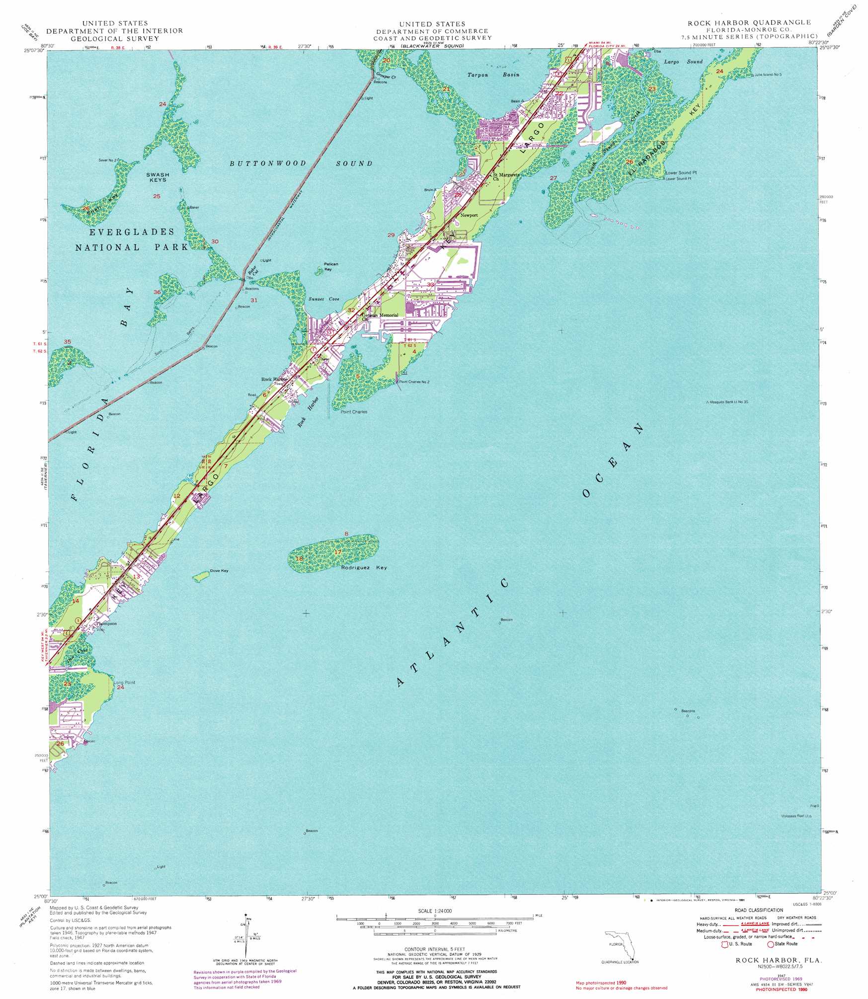
USGS Topo Quad 25080a4 - 1:24,000 scale
| Topo Map Name: | Rock Harbor |
| USGS Topo Quad ID: | 25080a4 |
| Print Size: | ca. 21 1/4" wide x 27" high |
| Southeast Coordinates: | 25° N latitude / 80.375° W longitude |
| Map Center Coordinates: | 25.0625° N latitude / 80.4375° W longitude |
| U.S. State: | FL |
| Filename: | O25080A4.jpg |
| Download Map JPG Image: | Rock Harbor topo map 1:24,000 scale |
| Map Type: | Topographic |
| Topo Series: | 7.5´ |
| Map Scale: | 1:24,000 |
| Source of Map Images: | United States Geological Survey (USGS) |
| Alternate Map Versions: |
Rock Harbor FL 1947, updated 1965 Download PDF Buy paper map Rock Harbor FL 1947, updated 1970 Download PDF Buy paper map Rock Harbor FL 1947, updated 1976 Download PDF Buy paper map Rock Harbor FL 1947, updated 1991 Download PDF Buy paper map Rock Harbor FL 1949 Download PDF Buy paper map Rock Harbor FL 2012 Download PDF Buy paper map Rock Harbor FL 2015 Download PDF Buy paper map |
1:24,000 Topo Quads surrounding Rock Harbor
Taylor Slough |
Royal Palm Ranger Station Se |
Glades |
Card Sound |
Pacific Reef |
Madeira Bay |
Joe Bay |
Blackwater Sound |
Garden Cove |
|
Calusa Keys |
Tavernier |
Rock Harbor |
||
Upper Matecumbe Key |
Plantation Key |
|||
Lower Matecumbe Key |
> Back to 25080a1 at 1:100,000 scale
> Back to 25080a1 at 1:250,000 scale
> Back to U.S. Topo Maps home
Rock Harbor topo map: Gazetteer
Rock Harbor: Bars
Triangles elevation 0m 0′White Bank Dry Rocks elevation 0m 0′
Rock Harbor: Basins
Tarpon Basin elevation 0m 0′Rock Harbor: Bays
Buttonwood Sound elevation 0m 0′Rock Harbor elevation 0m 0′
Sunset Cove elevation 0m 0′
Rock Harbor: Capes
Long Point elevation 0m 0′Lower Sound Point elevation 0m 0′
Point Charles elevation 0m 0′
Sunset Point elevation 0m 0′
Rock Harbor: Channels
Baker Cut elevation 0m 0′Molasses Reef Channel elevation 0m 0′
Rock Harbor: Guts
Dove Creek elevation 0m 0′Grouper Creek elevation 0m 0′
South Creek elevation 0m 0′
Rock Harbor: Islands
Dove Key elevation 0m 0′El Radabob Key elevation 0m 0′
Pelican Key elevation 0m 0′
Rodriguez Key elevation 0m 0′
Shell Key elevation 0m 0′
Swash Keys elevation 0m 0′
Rock Harbor: Parks
John Pennekamp Coral Reef State Park elevation 0m 0′Rock Harbor: Populated Places
Coastal Waterway Park Mobile Home Park elevation 1m 3′Key Largo elevation 2m 6′
Key Largo Park elevation 3m 9′
Newport elevation 3m 9′
Paradise Point Mobile Home Park elevation 1m 3′
Riptide Trailer Park elevation 3m 9′
Rock Harbor elevation 3m 9′
Rock Harbor Marina East Mobile Home Park elevation 1m 3′
Sunset Point elevation 1m 3′
Thompson elevation 1m 3′
Travel Trailer Town elevation 1m 3′
Rock Harbor: Streams
South Sound Creek elevation 0m 0′South Sound Creek elevation 0m 0′
Rock Harbor digital topo map on disk
Buy this Rock Harbor topo map showing relief, roads, GPS coordinates and other geographical features, as a high-resolution digital map file on DVD: