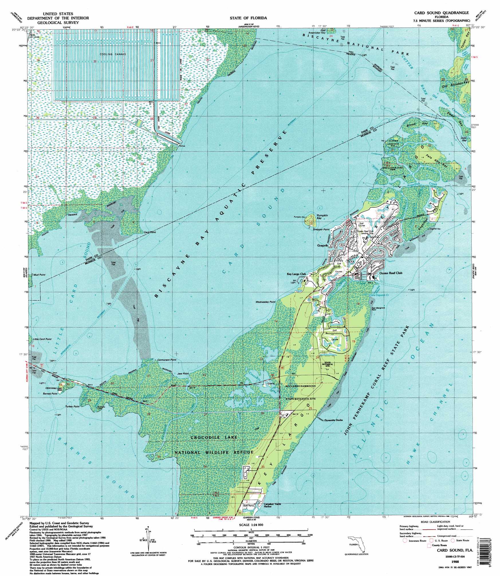
Card Sound Topo Map Florida
To zoom in, hover over the map of Card Sound
USGS Topo Quad 25080c3 - 1:24,000 scale
| Topo Map Name: | Card Sound |
| USGS Topo Quad ID: | 25080c3 |
| Print Size: | ca. 21 1/4" wide x 27" high |
| Southeast Coordinates: | 25.25° N latitude / 80.25° W longitude |
| Map Center Coordinates: | 25.3125° N latitude / 80.3125° W longitude |
| U.S. State: | FL |
| Filename: | O25080C3.jpg |
| Download Map JPG Image: | Card Sound topo map 1:24,000 scale |
| Map Type: | Topographic |
| Topo Series: | 7.5´ |
| Map Scale: | 1:24,000 |
| Source of Map Images: | United States Geological Survey (USGS) |
| Alternate Map Versions: |
Card Sound FL 1949 Download PDF Buy paper map Card Sound FL 1956, updated 1957 Download PDF Buy paper map Card Sound FL 1956, updated 1965 Download PDF Buy paper map Card Sound FL 1956, updated 1970 Download PDF Buy paper map Card Sound FL 1956, updated 1974 Download PDF Buy paper map Card Sound FL 1956, updated 1983 Download PDF Buy paper map Card Sound FL 1988, updated 1988 Download PDF Buy paper map Card Sound FL 1988, updated 1988 Download PDF Buy paper map Card Sound FL 2012 Download PDF Buy paper map Card Sound FL 2015 Download PDF Buy paper map |
1:24,000 Topo Quads surrounding Card Sound
Grossman Hammock |
Goulds |
Perrine |
Soldier Key |
|
Royal Palm Ranger Station |
Homestead |
Arsenicker Keys |
Elliott Key |
|
Royal Palm Ranger Station Se |
Glades |
Card Sound |
Pacific Reef |
|
Joe Bay |
Blackwater Sound |
Garden Cove |
||
Tavernier |
Rock Harbor |
> Back to 25080a1 at 1:100,000 scale
> Back to 25080a1 at 1:250,000 scale
> Back to U.S. Topo Maps home
Card Sound topo map: Gazetteer
Card Sound: Airports
Ocean Reef Club Airport elevation 1m 3′Ocean Reef Club Landing Strip elevation 1m 3′
Card Sound: Bars
Card Bank elevation 0m 0′Cutter Bank elevation 0m 0′
Card Sound: Bays
Card Sound elevation 0m 0′Little Card Sound elevation 0m 0′
Card Sound: Capes
Barnes Point elevation 0m 0′Card Point elevation 0m 0′
Cormorant Point elevation 0m 0′
High Mangrove Point elevation 0m 0′
Jew Point elevation 0m 0′
Little Card Point elevation 0m 0′
Mud Point elevation 0m 0′
Snapper Point elevation 0m 0′
Turkey Point elevation 0m 0′
Wednesday Point elevation 0m 0′
Card Sound: Channels
Broad Creek elevation 0m 0′Card Point Cut elevation 0m 0′
Mosquito Creek elevation 0m 0′
Old Rhodes Channel elevation 0m 0′
Steamboat Creek elevation 0m 0′
Card Sound: Guts
Angelfish Creek elevation 0m 0′Crane Creek elevation 1m 3′
Linderman Creek elevation 0m 0′
Little Angelfish Creek elevation 0m 0′
Little Dispatch Creek elevation 0m 0′
Little Pumpkin Creek elevation 0m 0′
Middle Creek elevation 0m 0′
Pumpkin Creek elevation 1m 3′
Saunders Creek elevation 0m 0′
South Broad Creek elevation 0m 0′
Tubbys Creek elevation 0m 0′
Card Sound: Harbors
Ocean Reef Harbor elevation 0m 0′Card Sound: Islands
Angelfish Key elevation 2m 6′Broad Key elevation 0m 0′
Linderman Key elevation 0m 0′
Little Totten Key elevation 1m 3′
Palo Alto Key elevation 2m 6′
Pumpkin Key elevation 2m 6′
Card Sound: Lakes
Crocodile Lake elevation 0m 0′Card Sound: Parks
Crocodile Lake National Wildlife Refuge elevation 0m 0′Key Largo Hammocks Botanical State Park elevation 1m 3′
New Mahogany Hammock State Botanical Site elevation 1m 3′
Card Sound: Populated Places
Carysfort Yacht Harbor elevation 0m 0′Dynamite Docks elevation 0m 0′
Gold Key elevation 1m 3′
Grayvik elevation 2m 6′
North Key Largo elevation 0m 0′
Card Sound: Streams
Dispatch Creek elevation 0m 0′Card Sound digital topo map on disk
Buy this Card Sound topo map showing relief, roads, GPS coordinates and other geographical features, as a high-resolution digital map file on DVD: