Fortymile Bend Topo Map Florida
To zoom in, hover over the map of Fortymile Bend
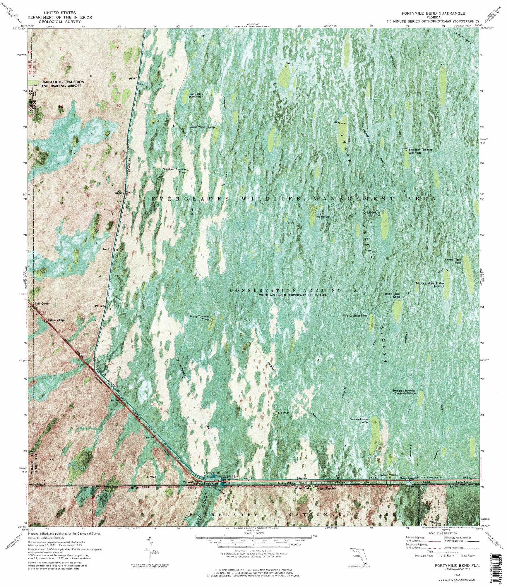
USGS Topo Quad 25080g7 - 1:24,000 scale
| Topo Map Name: | Fortymile Bend |
| USGS Topo Quad ID: | 25080g7 |
| Print Size: | ca. 21 1/4" wide x 27" high |
| Southeast Coordinates: | 25.75° N latitude / 80.75° W longitude |
| Map Center Coordinates: | 25.8125° N latitude / 80.8125° W longitude |
| U.S. State: | FL |
| Filename: | P25080G7.jpg |
| Download Map JPG Image: | Fortymile Bend topo map 1:24,000 scale |
| Map Type: | Orthophoto |
| Topo Series: | 7.5´ |
| Map Scale: | 1:24,000 |
| Source of Map Images: | United States Geological Survey (USGS) |
| Alternate Map Versions: |
Fortymile Bend FL 1973, updated 1975 Download PDF Buy paper map Fortymile Bend FL 1973, updated 1984 Download PDF Buy paper map Fortymile Bend FL 1973, updated 1984 Download PDF Buy paper map Fortymile Bend FL 1995, updated 1999 Download PDF Buy paper map Fortymile Bend FL 2012 Download PDF Buy paper map Fortymile Bend FL 2015 Download PDF Buy paper map |
1:24,000 Topo Quads surrounding Fortymile Bend
Immokalee 4 Se |
Everglades 3 Sw |
Everglades 3 Se |
Everglades 4 Sw |
Everglades 4 Se |
Monroe Station Ne |
North Of Fiftymile Bend |
North Of Fortymile Bend |
Custard Apple Hammock |
West Of Pennsuco |
Monroe Station |
Fiftymile Bend |
Fortymile Bend |
Long Island |
Coopertown |
Big Boy Lake |
Lostmans Trail |
Shark Valley Lookout Tower |
Chekika Island |
South Of Coopertown |
Big Lostmans Bay |
Indian Camp Creek |
Panther Mound |
Black Hammock |
Grossman Hammock |
> Back to 25080e1 at 1:100,000 scale
> Back to 25080a1 at 1:250,000 scale
> Back to U.S. Topo Maps home
Fortymile Bend topo map: Gazetteer
Fortymile Bend: Canals
Tamiami Canal Number C-4 elevation 2m 6′Fortymile Bend: Islands
Big Hammock elevation 2m 6′Jack Clay Hammock elevation 2m 6′
Miccosukee Tribe Island elevation 2m 6′
Fortymile Bend: Levees
Levee 28 elevation 2m 6′Fortymile Bend: Populated Places
Fortymile Bend elevation 2m 6′Smallpox Tommies Old Place elevation 2m 6′
Fortymile Bend: Trails
Tamiami Trail elevation 2m 6′Fortymile Bend digital topo map on disk
Buy this Fortymile Bend topo map showing relief, roads, GPS coordinates and other geographical features, as a high-resolution digital map file on DVD: