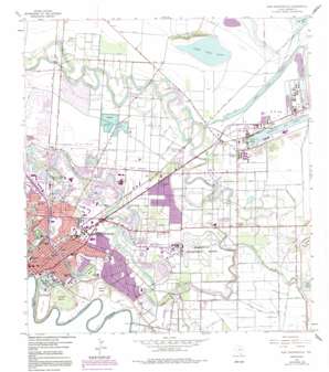
East Brownsville Topo Map Texas
To zoom in, hover over the map of East Brownsville
USGS Topo Quad 25097h4 - 1:24,000 scale
| Topo Map Name: | East Brownsville |
| USGS Topo Quad ID: | 25097h4 |
| Print Size: | ca. 21 1/4" wide x 27" high |
| Southeast Coordinates: | 25.875° N latitude / 97.375° W longitude |
| Map Center Coordinates: | 25.9375° N latitude / 97.4375° W longitude |
| U.S. State: | TX |
| Filename: | o25097h4.jpg |
| Download Map JPG Image: | East Brownsville topo map 1:24,000 scale |
| Map Type: | Topographic |
| Topo Series: | 7.5´ |
| Map Scale: | 1:24,000 |
| Source of Map Images: | United States Geological Survey (USGS) |
| Alternate Map Versions: |
East Brownsville TX 1930 Download PDF Buy paper map East Brownsville TX 1955, updated 1957 Download PDF Buy paper map East Brownsville TX 1955, updated 1961 Download PDF Buy paper map East Brownsville TX 1955, updated 1968 Download PDF Buy paper map East Brownsville TX 1955, updated 1971 Download PDF Buy paper map East Brownsville TX 1955, updated 1984 Download PDF Buy paper map East Brownsville TX 1955, updated 1991 Download PDF Buy paper map East Brownsville TX 2010 Download PDF Buy paper map East Brownsville TX 2012 Download PDF Buy paper map East Brownsville TX 2016 Download PDF Buy paper map |
1:24,000 Topo Quads surrounding East Brownsville
Harlingen |
Rio Hondo |
Laguna Atascosa |
La Coma |
Port Isabel Nw |
La Paloma |
Olmito |
Los Fresnos |
Laguna Vista |
Port Isabel |
West Brownsville |
East Brownsville |
Palmito Hill |
Mouth Of Rio Grande |
|
Southmost |
||||
> Back to 25097e1 at 1:100,000 scale
> Back to 25096a1 at 1:250,000 scale
> Back to U.S. Topo Maps home
East Brownsville topo map: Gazetteer
East Brownsville: Airports
Brownsville-South Padre Island International Airport elevation 5m 16′Resaca Airstrip elevation 6m 19′
East Brownsville: Bridges
Gateway Bridge elevation 5m 16′East Brownsville: Canals
Rancho Viejo Floodway elevation 2m 6′East Brownsville: Harbors
Brownsville Ship Harbor elevation 0m 0′East Brownsville: Lakes
Fort Brown Resaca elevation 8m 26′Loma Alta Lake elevation 1m 3′
Resaca de la Palma elevation 7m 22′
Town Resaca elevation 7m 22′
East Brownsville: Levees
Jeronimo Banco elevation 5m 16′Las Comas Banco elevation 5m 16′
Los Tomates Banco elevation 10m 32′
Lozano Banco elevation 9m 29′
San Miguel Banco elevation 4m 13′
East Brownsville: Parks
Central Avenue Park elevation 7m 22′Dean Porter Park elevation 11m 36′
Friendship Gardens elevation 10m 32′
Historical Monument elevation 9m 29′
Las Palomas Wildlife Management Area - Voshell Unit elevation 8m 26′
Lincoln Park elevation 9m 29′
Morningside Park elevation 8m 26′
Portway Acres Park elevation 5m 16′
Ringgold Park elevation 11m 36′
Scorpion Baseball Field elevation 9m 29′
Tony Gonzales Park elevation 8m 26′
Victoria Park elevation 10m 32′
Washington Park elevation 9m 29′
East Brownsville: Populated Places
21 Subdivision Colonia elevation 7m 22′Barrios Colonia elevation 4m 13′
Bautista Colonia elevation 6m 19′
Betty Acres Colonia elevation 7m 22′
Boca Chica and Medford Colonia elevation 6m 19′
Brownsville elevation 10m 32′
Cameron Park elevation 5m 16′
Cameron Park Colonia elevation 8m 26′
Central Estates Colonia elevation 5m 16′
Cielito Lindo Colonia elevation 6m 19′
Coronado Colonia elevation 8m 26′
Dakota Mobile Home Park Colonia elevation 5m 16′
Dockberry Estates Colonia elevation 6m 19′
FM 802-511 Colonia elevation 5m 16′
Four Corners elevation 8m 26′
Harris Tract Colonia elevation 6m 19′
Houston Road East Colonia elevation 5m 16′
Illinois Heights Colonia elevation 6m 19′
Jaime Lake Colonia elevation 6m 19′
Kellers Corner Colonia elevation 7m 22′
Los Cuates South Colonia elevation 7m 22′
Port Brownsville elevation 4m 13′
Praxedis Saldivar Colonia elevation 7m 22′
Reid Hope King elevation 5m 16′
Reid Hope King Colonia elevation 6m 19′
Saldivar Colonia elevation 5m 16′
Stewart Colonia elevation 5m 16′
Travis and Vermillion Colonia elevation 6m 19′
Travis Road Colonia elevation 4m 13′
Valle Escondido Colonia elevation 4m 13′
Villa Pancho elevation 4m 13′
Villa Pancho Colonia elevation 4m 13′
East Brownsville: Summits
Loma Alta elevation 12m 39′East Brownsville digital topo map on disk
Buy this East Brownsville topo map showing relief, roads, GPS coordinates and other geographical features, as a high-resolution digital map file on DVD:


