Cooper City Topo Map Florida
To zoom in, hover over the map of Cooper City
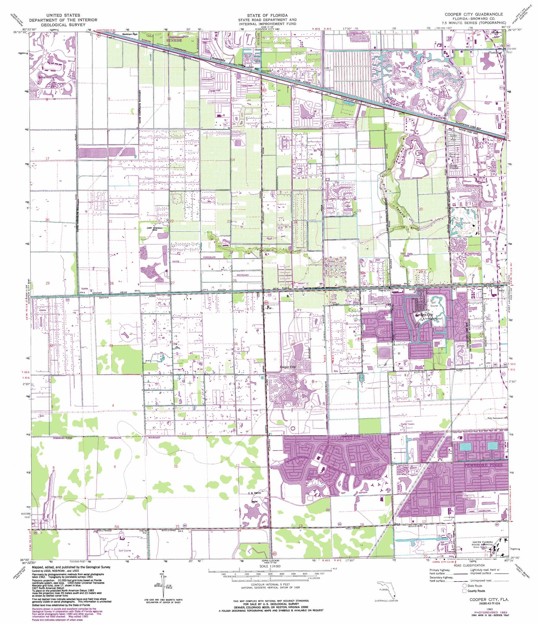
USGS Topo Quad 26080a3 - 1:24,000 scale
| Topo Map Name: | Cooper City |
| USGS Topo Quad ID: | 26080a3 |
| Print Size: | ca. 21 1/4" wide x 27" high |
| Southeast Coordinates: | 26° N latitude / 80.25° W longitude |
| Map Center Coordinates: | 26.0625° N latitude / 80.3125° W longitude |
| U.S. State: | FL |
| Filename: | O26080A3.jpg |
| Download Map JPG Image: | Cooper City topo map 1:24,000 scale |
| Map Type: | Topographic |
| Topo Series: | 7.5´ |
| Map Scale: | 1:24,000 |
| Source of Map Images: | United States Geological Survey (USGS) |
| Alternate Map Versions: |
Cooper City FL 1963, updated 1965 Download PDF Buy paper map Cooper City FL 1963, updated 1970 Download PDF Buy paper map Cooper City FL 1963, updated 1977 Download PDF Buy paper map Cooper City FL 1963, updated 1984 Download PDF Buy paper map Cooper City FL 1994, updated 2000 Download PDF Buy paper map Cooper City FL 2012 Download PDF Buy paper map Cooper City FL 2015 Download PDF Buy paper map |
1:24,000 Topo Quads surrounding Cooper City
Everglades 1 Se |
Fort Lauderdale 2 Sw |
Fort Lauderdale 2 Se |
West Dixie Bend |
Boca Raton |
Everglades 4 Ne |
Andytown |
Cooper City Ne |
Fort Lauderdale North |
Pompano Beach |
Everglades 4 Se |
Cooper City Sw |
Cooper City |
Fort Lauderdale South |
Port Everglades |
West Of Pennsuco |
Pennsuco |
Opa-Locka |
North Miami |
|
Coopertown |
Hialeah Sw |
Hialeah |
Miami |
> Back to 26080a1 at 1:100,000 scale
> Back to 26080a1 at 1:250,000 scale
> Back to U.S. Topo Maps home
Cooper City topo map: Gazetteer
Cooper City: Airports
Cleveland Clinic Florida Hospital Heliport elevation 1m 3′MacIvor and Friends Airstrip elevation 1m 3′
Cooper City: Canals
North Fork Snake Creek Canal elevation 3m 9′Panama Canal elevation 1m 3′
Cooper City: Crossings
Interchange 11A and 11B elevation 1m 3′Interchange 13A and 13B elevation 2m 6′
Interchange 15 elevation 1m 3′
Interchange 19 elevation 1m 3′
Interchange 1A elevation 1m 3′
Interchange 1B elevation 3m 9′
Interchange 2 elevation 2m 6′
Interchange 3 elevation 2m 6′
Interchange 4 elevation 2m 6′
Interchange 5 elevation 2m 6′
Interchange 9A and 9B elevation 3m 9′
Cooper City: Islands
Pine Island elevation 2m 6′Cooper City: Parks
Flamingo Road County Park elevation 3m 9′Pine Island Ridge County Park elevation 2m 6′
Snake Creek Park elevation 1m 3′
Tree Tops Park elevation 2m 6′
Cooper City: Populated Places
Cheron Village Mobile Home Park elevation 1m 3′Cooper City elevation 2m 6′
East Pine Ridge Mobile Home Park elevation 1m 3′
Kings Manor Estates Mobile Home Park elevation 1m 3′
Melalevca Isles elevation 1m 3′
Palm Haven Mobile Home Park elevation 1m 3′
Paradise Village Mobile Home Park elevation 1m 3′
Park City West Mobile Home Park elevation 1m 3′
Pine Island Ridge elevation 2m 6′
Rexmere Village Mobile Home Park elevation 1m 3′
Royal Palm Ranches elevation 1m 3′
Southwest Ranches elevation 1m 3′
Sunshine Acres elevation 1m 3′
Sunshine City Mobile Home Park elevation 1m 3′
Sunshine Ranches elevation 1m 3′
Sunshine Village Mobile Home Park elevation 1m 3′
Western Hills Estates Mobile Home Park elevation 1m 3′
Cooper City: Post Offices
Davie Post Office elevation 2m 6′Flamingo Post Office elevation 1m 3′
Pembroke Pines Post Office elevation 1m 3′
Pembroke Pines Post Office elevation 1m 3′
Weston Branch Post Office elevation 1m 3′
Cooper City digital topo map on disk
Buy this Cooper City topo map showing relief, roads, GPS coordinates and other geographical features, as a high-resolution digital map file on DVD: