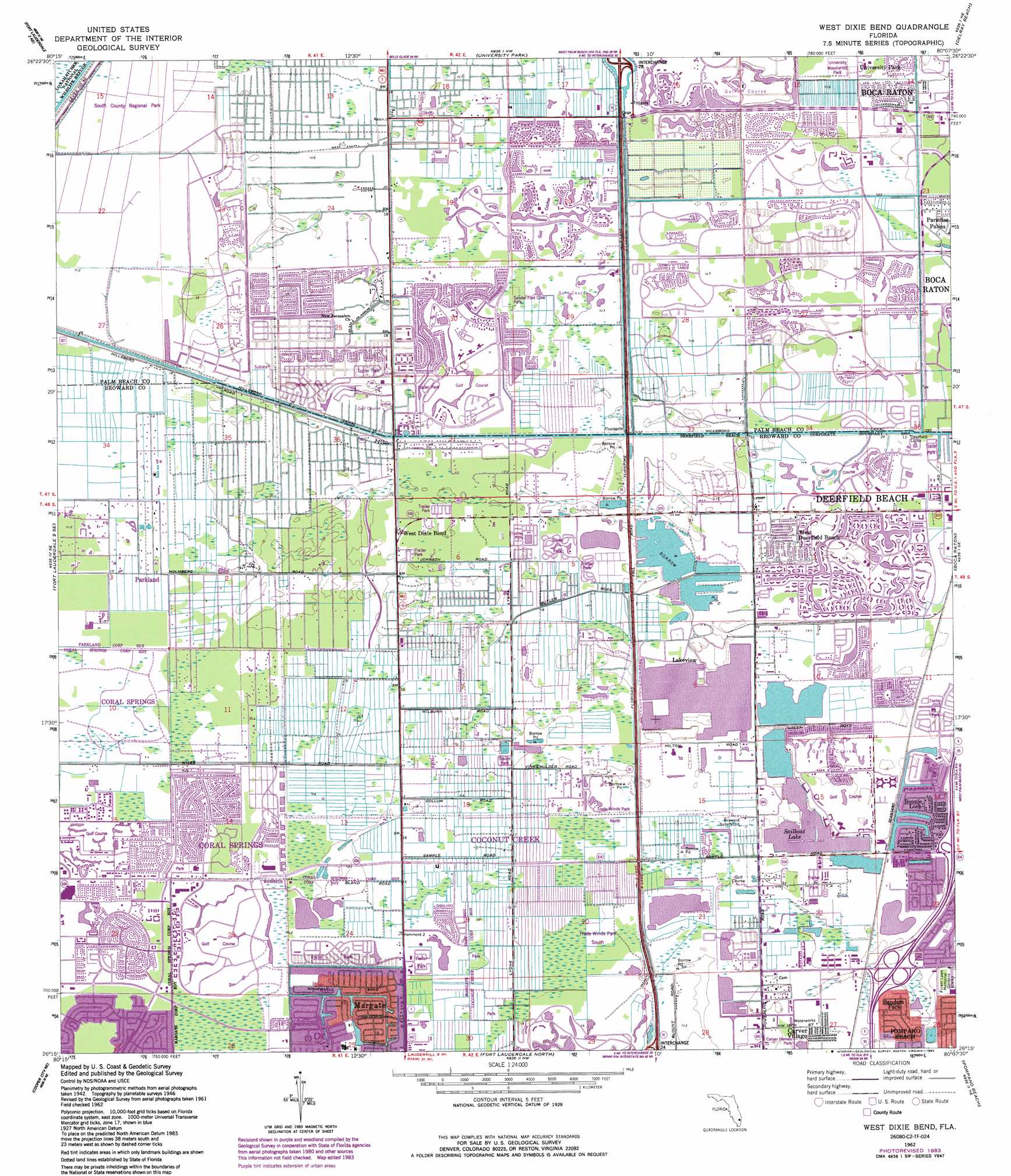
West Dixie Bend Topo Map Florida
To zoom in, hover over the map of West Dixie Bend
USGS Topo Quad 26080c2 - 1:24,000 scale
| Topo Map Name: | West Dixie Bend |
| USGS Topo Quad ID: | 26080c2 |
| Print Size: | ca. 21 1/4" wide x 27" high |
| Southeast Coordinates: | 26.25° N latitude / 80.125° W longitude |
| Map Center Coordinates: | 26.3125° N latitude / 80.1875° W longitude |
| U.S. State: | FL |
| Filename: | O26080C2.jpg |
| Download Map JPG Image: | West Dixie Bend topo map 1:24,000 scale |
| Map Type: | Topographic |
| Topo Series: | 7.5´ |
| Map Scale: | 1:24,000 |
| Source of Map Images: | United States Geological Survey (USGS) |
| Alternate Map Versions: |
West Dixie Bend FL 1946, updated 1958 Download PDF Buy paper map West Dixie Bend FL 1949 Download PDF Buy paper map West Dixie Bend FL 1962, updated 1964 Download PDF Buy paper map West Dixie Bend FL 1962, updated 1970 Download PDF Buy paper map West Dixie Bend FL 1962, updated 1983 Download PDF Buy paper map West Dixie Bend FL 2012 Download PDF Buy paper map West Dixie Bend FL 2015 Download PDF Buy paper map |
1:24,000 Topo Quads surrounding West Dixie Bend
Loxahatchee Sw |
Loxahatchee Se |
Greenacres City |
Lake Worth |
|
Fort Lauderdale 2 Nw |
Fort Lauderdale 2 Ne |
University Park |
Delray Beach |
|
Fort Lauderdale 2 Sw |
Fort Lauderdale 2 Se |
West Dixie Bend |
Boca Raton |
|
Andytown |
Cooper City Ne |
Fort Lauderdale North |
Pompano Beach |
|
Cooper City Sw |
Cooper City |
Fort Lauderdale South |
Port Everglades |
> Back to 26080a1 at 1:100,000 scale
> Back to 26080a1 at 1:250,000 scale
> Back to U.S. Topo Maps home
West Dixie Bend topo map: Gazetteer
West Dixie Bend: Airports
Camino Real Centre Heliport elevation 4m 13′West Boca Medical Center Heliport elevation 4m 13′
West Dixie Bend: Crossings
Interchange 38A and 38B elevation 2m 6′Interchange 39 elevation 3m 9′
Interchange 5 elevation 4m 13′
Interchange 6 elevation 6m 19′
West Dixie Bend: Dams
Deerfield Locks elevation 4m 13′West Dixie Bend: Lakes
Sailboat Lake elevation 2m 6′West Dixie Bend: Parks
Carver Homes Park elevation 3m 9′Sandal Foot Cove Park elevation 5m 16′
Tall Cypress Natural Area elevation 4m 13′
Trade Winds Park North elevation 3m 9′
Trade Winds Park South elevation 4m 13′
University Woodlands Park elevation 4m 13′
West Dixie Bend: Populated Places
Boca Del Mar elevation 4m 13′Boca Pointe elevation 4m 13′
Bonnie Loch elevation 4m 13′
Carver Village elevation 3m 9′
Coconut Creek elevation 2m 6′
Coral Cay Plantation Mobile Home Park elevation 4m 13′
Coral Lake Mobile Home Park elevation 4m 13′
Country Knolls Mobile Home Park elevation 4m 13′
Country Lakes Community Mobile Home Park elevation 4m 13′
Crystal Lake elevation 4m 13′
Deerfield Lake Mobile Home Park elevation 4m 13′
Hillsboro Mobile Home Park elevation 4m 13′
Hillsboro Pines elevation 4m 13′
Hillsboro Ranches elevation 4m 13′
Hometown Country Lakes Mobile Home Park elevation 4m 13′
Lakeview elevation 4m 13′
Leisureville elevation 4m 13′
Loch Lomond elevation 5m 16′
Mission Bay elevation 4m 13′
Paradise Palms elevation 4m 13′
Parkland elevation 4m 13′
Parkridge Mobile Home Park elevation 4m 13′
Rancho Margate Mobile Home Park elevation 4m 13′
Sandalfoot Cove elevation 4m 13′
Sanders Park elevation 5m 16′
Tallowwood Isle Mobile Home Park elevation 5m 16′
Tidewater Estates Mobile Home Park elevation 3m 9′
West Deerfield Beach elevation 4m 13′
West Dixie Bend elevation 4m 13′
Whispering Pines Addition Mobile Home Park elevation 4m 13′
Woodsetter North elevation 4m 13′
West Dixie Bend: Post Offices
Coconut Creek Post Office elevation 4m 13′Coral Reef Post Office elevation 4m 13′
Village Post Office elevation 3m 9′
West Dixie Bend digital topo map on disk
Buy this West Dixie Bend topo map showing relief, roads, GPS coordinates and other geographical features, as a high-resolution digital map file on DVD: