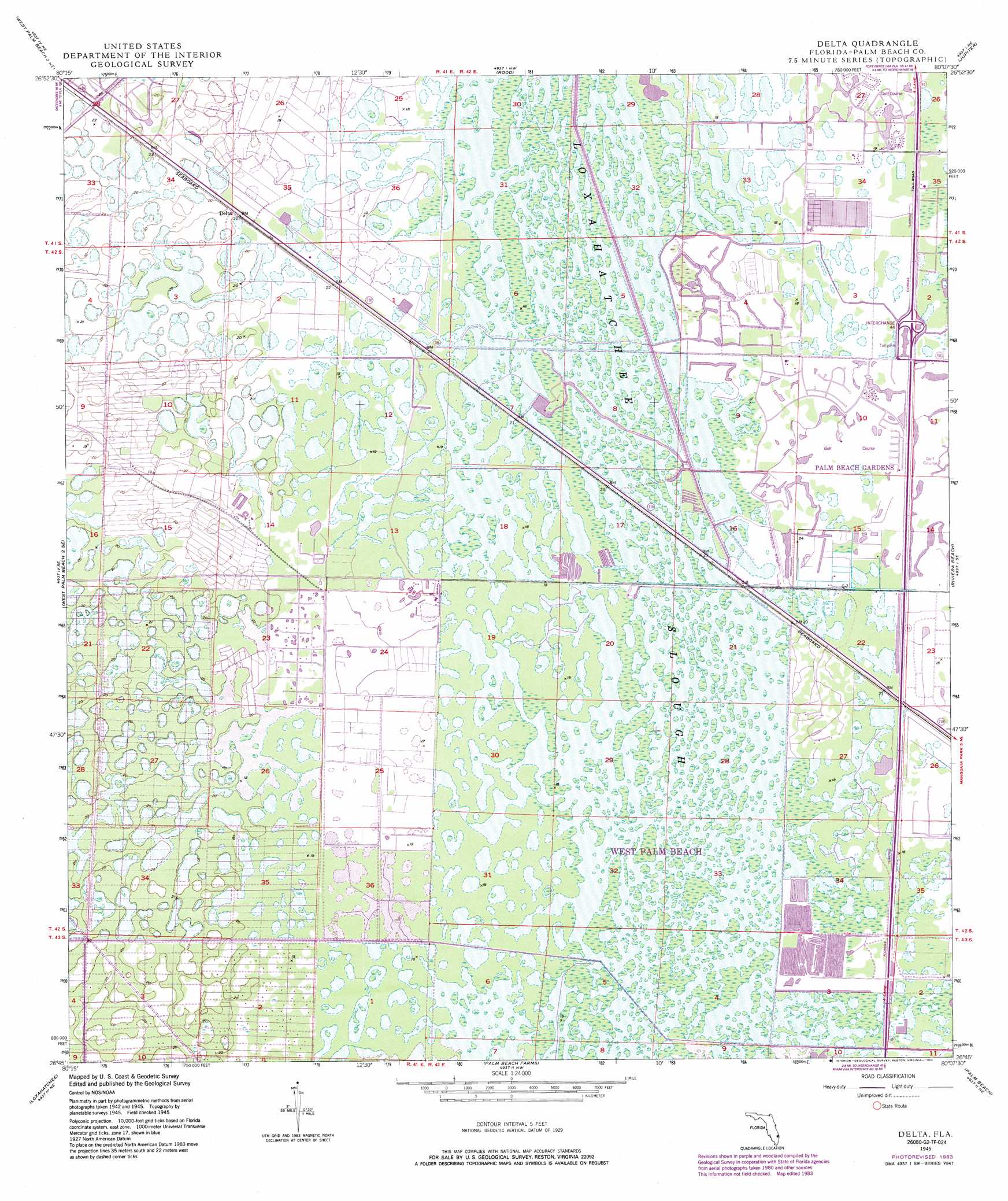
Delta Topo Map Florida
To zoom in, hover over the map of Delta
USGS Topo Quad 26080g2 - 1:24,000 scale
| Topo Map Name: | Delta |
| USGS Topo Quad ID: | 26080g2 |
| Print Size: | ca. 21 1/4" wide x 27" high |
| Southeast Coordinates: | 26.75° N latitude / 80.125° W longitude |
| Map Center Coordinates: | 26.8125° N latitude / 80.1875° W longitude |
| U.S. State: | FL |
| Filename: | O26080G2.jpg |
| Download Map JPG Image: | Delta topo map 1:24,000 scale |
| Map Type: | Topographic |
| Topo Series: | 7.5´ |
| Map Scale: | 1:24,000 |
| Source of Map Images: | United States Geological Survey (USGS) |
| Alternate Map Versions: |
Delta FL 1945, updated 1961 Download PDF Buy paper map Delta FL 1945, updated 1968 Download PDF Buy paper map Delta FL 1945, updated 1974 Download PDF Buy paper map Delta FL 1945, updated 1983 Download PDF Buy paper map Delta FL 1945, updated 1984 Download PDF Buy paper map Delta FL 1945, updated 1984 Download PDF Buy paper map Delta FL 1950 Download PDF Buy paper map Delta FL 2012 Download PDF Buy paper map Delta FL 2015 Download PDF Buy paper map |
1:24,000 Topo Quads surrounding Delta
Indian Town |
Indiantown Se |
Gomez |
Hobe Sound |
|
West Palm Beach 2 Nw |
West Palm Beach 2 Ne |
Rood |
Jupiter |
|
Big Mound South |
West of Delta |
Delta |
Riviera Beach |
|
Loxahatchee Nw |
Loxahatchee |
Palm Beach Farms |
Palm Beach |
|
Loxahatchee Sw |
Loxahatchee Se |
Greenacres City |
Lake Worth |
> Back to 26080e1 at 1:100,000 scale
> Back to 26080a1 at 1:250,000 scale
> Back to U.S. Topo Maps home
Delta topo map: Gazetteer
Delta: Airports
PGA National Heliport elevation 5m 16′Delta: Guts
Loxahatchee Slough elevation 5m 16′Delta: Populated Places
Delta elevation 6m 19′Palm Beach Gardens elevation 5m 16′
Delta digital topo map on disk
Buy this Delta topo map showing relief, roads, GPS coordinates and other geographical features, as a high-resolution digital map file on DVD: