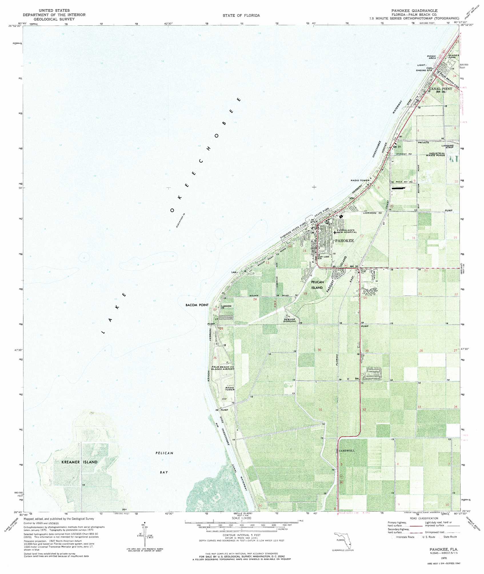
Pahokee Topo Map Florida
To zoom in, hover over the map of Pahokee
USGS Topo Quad 26080g6 - 1:24,000 scale
| Topo Map Name: | Pahokee |
| USGS Topo Quad ID: | 26080g6 |
| Print Size: | ca. 21 1/4" wide x 27" high |
| Southeast Coordinates: | 26.75° N latitude / 80.625° W longitude |
| Map Center Coordinates: | 26.8125° N latitude / 80.6875° W longitude |
| U.S. State: | FL |
| Filename: | P26080G6.jpg |
| Download Map JPG Image: | Pahokee topo map 1:24,000 scale |
| Map Type: | Orthophoto |
| Topo Series: | 7.5´ |
| Map Scale: | 1:24,000 |
| Source of Map Images: | United States Geological Survey (USGS) |
| Alternate Map Versions: |
Pahokee FL 1970, updated 1976 Download PDF Buy paper map Pahokee FL 2012 Download PDF Buy paper map Pahokee FL 2015 Download PDF Buy paper map |
1:24,000 Topo Quads surrounding Pahokee
Okeechobee Sw |
Okeechobee Se |
Okeechobee 4 Sw |
Okeechobee 4 Se |
Indian Town |
Cochrans Pass |
Port Mayaca |
West Palm Beach 2 Nw |
||
Clewiston North |
Pahokee |
Bryant |
Big Mound South |
|
Clewiston South |
Lake Harbor |
Belle Glade |
Sixmile Bend |
Loxahatchee Nw |
Lake Harbor Sw |
Lake Harbor Se |
Okeelanta |
Shawano |
Loxahatchee Sw |
> Back to 26080e1 at 1:100,000 scale
> Back to 26080a1 at 1:250,000 scale
> Back to U.S. Topo Maps home
Pahokee topo map: Gazetteer
Pahokee: Airports
Palm Beach County Glades Airport elevation 4m 13′Pahokee: Bays
Pelican Bay elevation 5m 16′Pahokee: Capes
Bacom Point elevation 5m 16′Pahokee: Islands
Kreamer Island elevation 4m 13′Padgett Island elevation 4m 13′
Pelican Island elevation 4m 13′
Pahokee: Parks
Glades Park elevation 6m 19′Pahokee State Park elevation 4m 13′
Pahokee: Populated Places
Barfield Mobile Home Park elevation 4m 13′Canal Point elevation 4m 13′
Cardwell elevation 4m 13′
Duncan Padgett Mobile Home Park elevation 4m 13′
Fremd Village elevation 4m 13′
Hanson Mobile Home Park elevation 4m 13′
Herring Mobile Home Park elevation 5m 16′
Keen Mobile Home Park elevation 4m 13′
King Bee Trailer Park elevation 4m 13′
Lakeshore Trailer Park elevation 5m 16′
May's Mobile Home Park elevation 4m 13′
Moss Mobile Home Park elevation 4m 13′
Murphy's Mobile Home Park elevation 4m 13′
Padgett Island elevation 4m 13′
Pahokee elevation 4m 13′
Pahokee Trailer Park elevation 5m 16′
Pelican River Mobile Home Park elevation 4m 13′
Shirley's Trailer Park elevation 4m 13′
Ushers Trailer Park elevation 4m 13′
Pahokee: Post Offices
Pahokee Post Office elevation 5m 16′Pahokee digital topo map on disk
Buy this Pahokee topo map showing relief, roads, GPS coordinates and other geographical features, as a high-resolution digital map file on DVD: