Estero Topo Map Florida
To zoom in, hover over the map of Estero
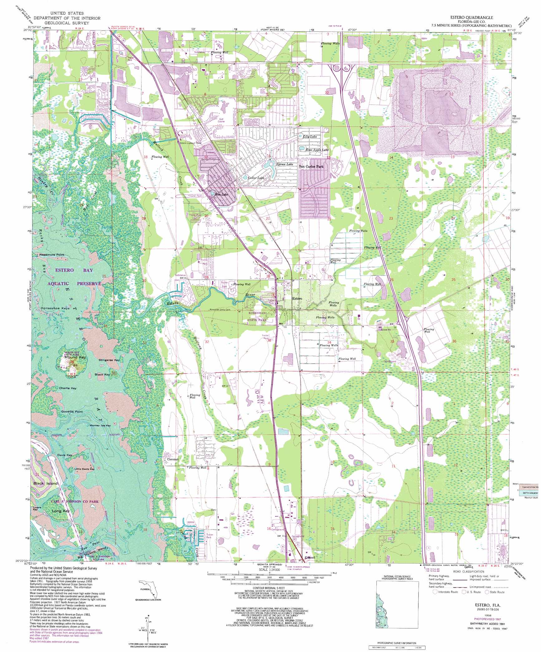
USGS Topo Quad 26081d7 - 1:24,000 scale
| Topo Map Name: | Estero |
| USGS Topo Quad ID: | 26081d7 |
| Print Size: | ca. 21 1/4" wide x 27" high |
| Southeast Coordinates: | 26.375° N latitude / 81.75° W longitude |
| Map Center Coordinates: | 26.4375° N latitude / 81.8125° W longitude |
| U.S. State: | FL |
| Filename: | O26081D7.jpg |
| Download Map JPG Image: | Estero topo map 1:24,000 scale |
| Map Type: | Topographic |
| Topo Series: | 7.5´ |
| Map Scale: | 1:24,000 |
| Source of Map Images: | United States Geological Survey (USGS) |
| Alternate Map Versions: |
Estero FL 1958, updated 1959 Download PDF Buy paper map Estero FL 1958, updated 1963 Download PDF Buy paper map Estero FL 1958, updated 1973 Download PDF Buy paper map Estero FL 1958, updated 1977 Download PDF Buy paper map Estero FL 1958, updated 1988 Download PDF Buy paper map Estero FL 1958, updated 1991 Download PDF Buy paper map Estero FL 2012 Download PDF Buy paper map Estero FL 2015 Download PDF Buy paper map |
1:24,000 Topo Quads surrounding Estero
Matlacha |
Fort Myers Nw |
Fort Myers |
Olga |
Alva |
Pine Island Center |
Fort Myers Sw |
Fort Myers Se |
Alva Sw |
Alva Se |
Sanibel |
Fort Myers Beach |
Estero |
Corkscrew Nw |
Corkscrew |
Bonita Springs |
Corkscrew Sw |
Corkscrew Se |
||
Naples North |
Belle Meade Nw |
Belle Meade Ne |
> Back to 26081a1 at 1:100,000 scale
> Back to 26080a1 at 1:250,000 scale
> Back to U.S. Topo Maps home
Estero topo map: Gazetteer
Estero: Airports
Williams Road Helistop elevation 4m 13′Estero: Bays
Estero Bay elevation 0m 0′Rocky Bay elevation 0m 0′
Estero: Capes
Goombs Point elevation 0m 0′Needmore Point elevation 0m 0′
Estero: Channels
New Pass elevation 0m 0′Spring Creek Channel elevation 0m 0′
Estero: Islands
Black Island elevation 0m 0′Black Key elevation 0m 0′
Charlie Key elevation 0m 0′
Davis Key elevation 0m 0′
Horseshoe Keys elevation 0m 0′
Little Davis Key elevation 0m 0′
Long Key elevation 0m 0′
Monkey Joe Key elevation 0m 0′
Mound Key elevation 5m 16′
Stingaree Key elevation 0m 0′
Estero: Lakes
Balsam Lake elevation 4m 13′Cedar Lake elevation 4m 13′
Lily Lake elevation 4m 13′
Pine Lake elevation 3m 9′
Rose Apple Lake elevation 4m 13′
Spruce Lake elevation 4m 13′
Estero: Parks
Carl E Johnson County Park (historical) elevation 0m 0′Estero Bay Aquatic Preserve elevation 4m 13′
Koreshan State Historic Site elevation 3m 9′
Mound Key Archaeological State Park elevation 2m 6′
Estero: Populated Places
Coconut elevation 0m 0′Council elevation 4m 13′
Estero elevation 4m 13′
Forest Island Park elevation 1m 3′
Miromar Lakes elevation 5m 16′
San Carlos Park elevation 5m 16′
Sunny Grove Park Mobile Home Park elevation 3m 9′
Tahiti Mobile Village elevation 3m 9′
Three Oaks elevation 5m 16′
Estero: Post Offices
Estero Post Office elevation 4m 13′Estero: Streams
Estero River elevation 0m 0′Halfway Creek elevation 1m 3′
Hendry Creek elevation 0m 0′
Mud Creek elevation 0m 0′
Mullock Creek elevation 0m 0′
Spring Creek elevation 0m 0′
Estero digital topo map on disk
Buy this Estero topo map showing relief, roads, GPS coordinates and other geographical features, as a high-resolution digital map file on DVD: