Alva Topo Map Florida
To zoom in, hover over the map of Alva
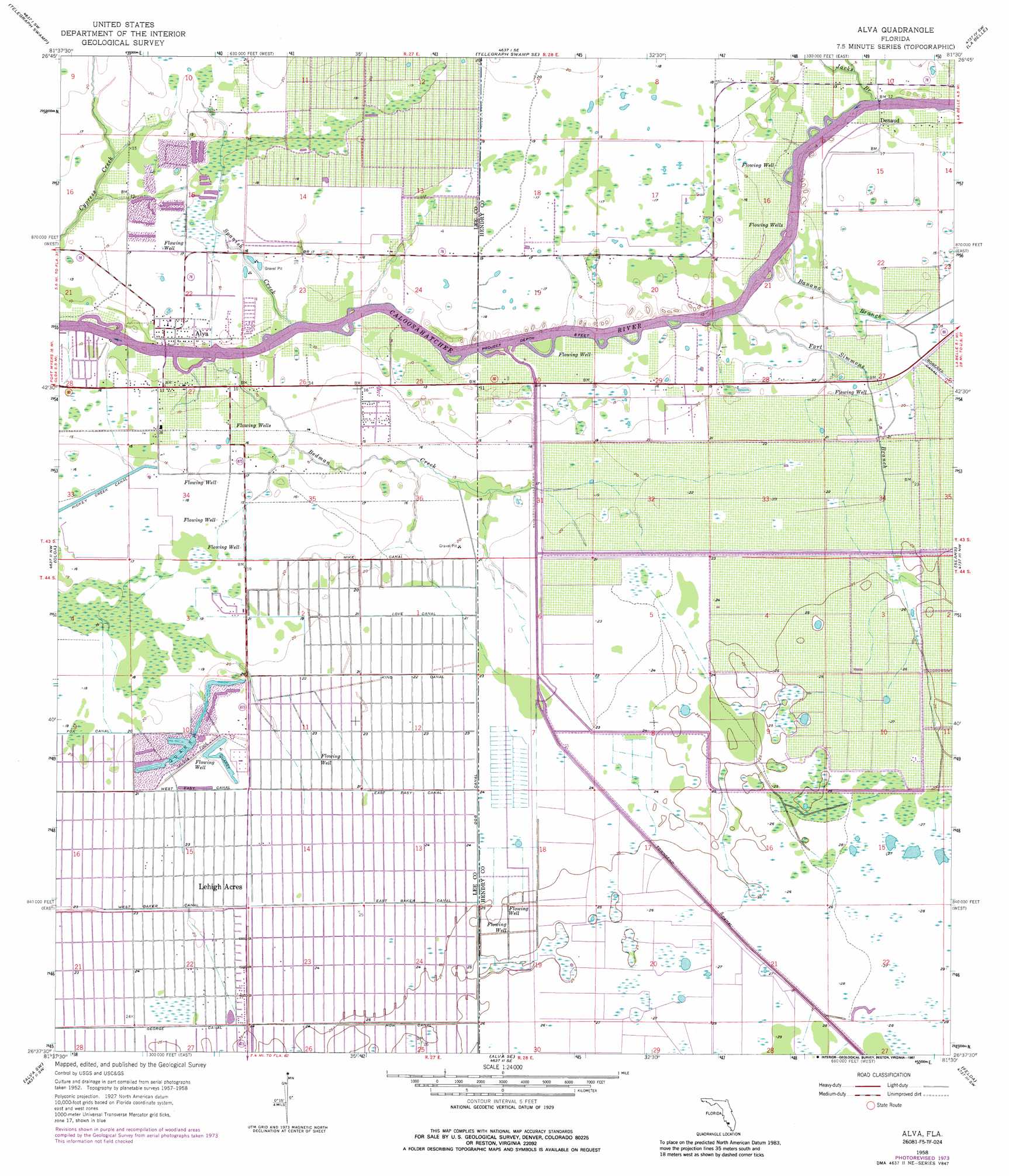
USGS Topo Quad 26081f5 - 1:24,000 scale
| Topo Map Name: | Alva |
| USGS Topo Quad ID: | 26081f5 |
| Print Size: | ca. 21 1/4" wide x 27" high |
| Southeast Coordinates: | 26.625° N latitude / 81.5° W longitude |
| Map Center Coordinates: | 26.6875° N latitude / 81.5625° W longitude |
| U.S. State: | FL |
| Filename: | O26081F5.jpg |
| Download Map JPG Image: | Alva topo map 1:24,000 scale |
| Map Type: | Topographic |
| Topo Series: | 7.5´ |
| Map Scale: | 1:24,000 |
| Source of Map Images: | United States Geological Survey (USGS) |
| Alternate Map Versions: |
Alva FL 1958, updated 1959 Download PDF Buy paper map Alva FL 1958, updated 1967 Download PDF Buy paper map Alva FL 1958, updated 1974 Download PDF Buy paper map Alva FL 1958, updated 1987 Download PDF Buy paper map Alva FL 2012 Download PDF Buy paper map Alva FL 2015 Download PDF Buy paper map |
1:24,000 Topo Quads surrounding Alva
Bermont |
Telegraph Swamp Nw |
Telegraph Swamp Ne |
La Belle Nw |
Palmdale |
Tuckers Corner |
Telegraph Swamp |
Telegraph Swamp Se |
La Belle |
Goodno |
Fort Myers |
Olga |
Alva |
Sears |
Felda Ne |
Fort Myers Se |
Alva Sw |
Alva Se |
Felda |
Felda Se |
Estero |
Corkscrew Nw |
Corkscrew |
Immokalee |
Immokalee Ne |
> Back to 26081e1 at 1:100,000 scale
> Back to 26080a1 at 1:250,000 scale
> Back to U.S. Topo Maps home
Alva topo map: Gazetteer
Alva: Airports
Cotton Strip elevation 4m 13′Williams Sky Manor Airport elevation 4m 13′
Alva: Bridges
Banana Branch Bridge elevation 5m 16′Fort Denaud Bridge elevation 4m 13′
Alva: Canals
Dog Canal elevation 6m 19′East Baker Canal elevation 6m 19′
East Easy Canal elevation 6m 19′
How Canal elevation 6m 19′
King Canal elevation 6m 19′
Love Canal elevation 6m 19′
Mike Canal elevation 6m 19′
Townsend Canal elevation 7m 22′
Alva: Populated Places
Alva elevation 5m 16′Charleston Park elevation 4m 13′
Denaud elevation 4m 13′
Lehigh Acres elevation 6m 19′
Oak Park Mobile Village elevation 3m 9′
Alva: Post Offices
Alva Post Office elevation 4m 13′Alva: Streams
Banana Branch elevation 2m 6′Bedman Creek elevation 1m 3′
Fort Simmons Branch elevation 1m 3′
Jacks Branch elevation 1m 3′
Spanish Creek elevation 1m 3′
Alva digital topo map on disk
Buy this Alva topo map showing relief, roads, GPS coordinates and other geographical features, as a high-resolution digital map file on DVD: