Olga Topo Map Florida
To zoom in, hover over the map of Olga
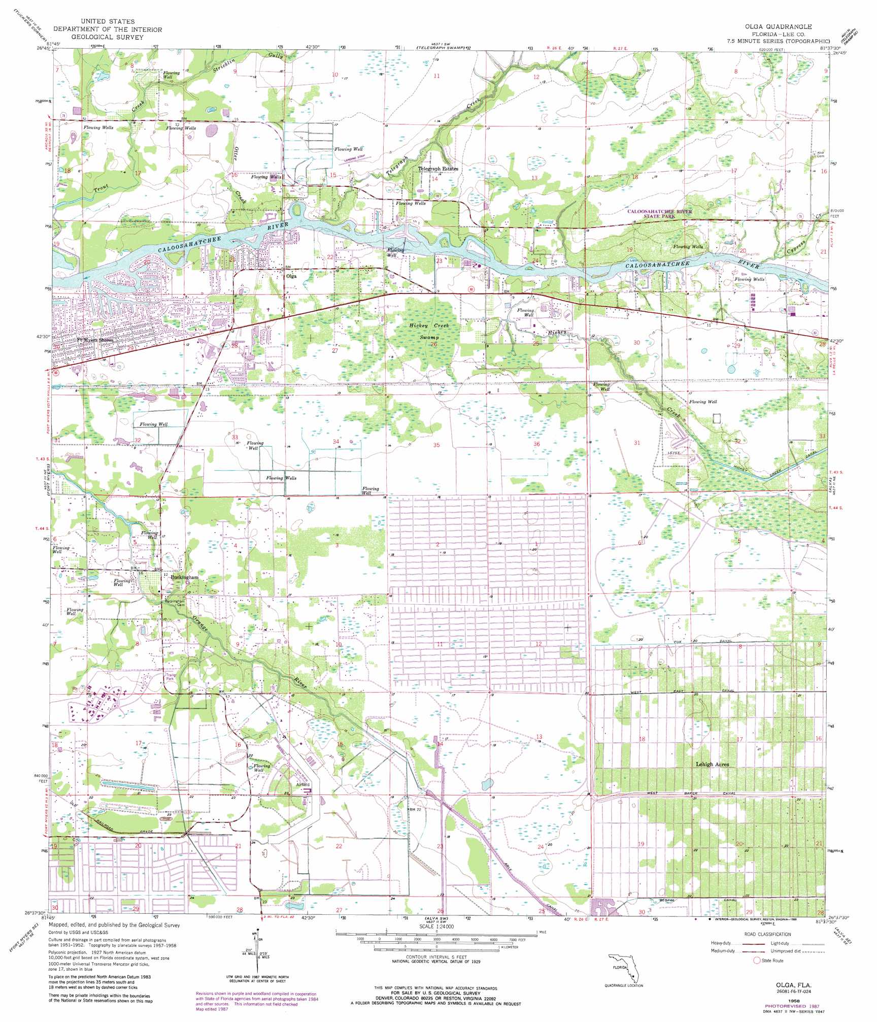
USGS Topo Quad 26081f6 - 1:24,000 scale
| Topo Map Name: | Olga |
| USGS Topo Quad ID: | 26081f6 |
| Print Size: | ca. 21 1/4" wide x 27" high |
| Southeast Coordinates: | 26.625° N latitude / 81.625° W longitude |
| Map Center Coordinates: | 26.6875° N latitude / 81.6875° W longitude |
| U.S. State: | FL |
| Filename: | O26081F6.jpg |
| Download Map JPG Image: | Olga topo map 1:24,000 scale |
| Map Type: | Topographic |
| Topo Series: | 7.5´ |
| Map Scale: | 1:24,000 |
| Source of Map Images: | United States Geological Survey (USGS) |
| Alternate Map Versions: |
Olga FL 1958, updated 1959 Download PDF Buy paper map Olga FL 1958, updated 1967 Download PDF Buy paper map Olga FL 1958, updated 1974 Download PDF Buy paper map Olga FL 1958, updated 1988 Download PDF Buy paper map Olga FL 2012 Download PDF Buy paper map Olga FL 2015 Download PDF Buy paper map |
1:24,000 Topo Quads surrounding Olga
Cleveland |
Bermont |
Telegraph Swamp Nw |
Telegraph Swamp Ne |
La Belle Nw |
Gilchrist |
Tuckers Corner |
Telegraph Swamp |
Telegraph Swamp Se |
La Belle |
Fort Myers Nw |
Fort Myers |
Olga |
Alva |
Sears |
Fort Myers Sw |
Fort Myers Se |
Alva Sw |
Alva Se |
Felda |
Fort Myers Beach |
Estero |
Corkscrew Nw |
Corkscrew |
Immokalee |
> Back to 26081e1 at 1:100,000 scale
> Back to 26080a1 at 1:250,000 scale
> Back to U.S. Topo Maps home
Olga topo map: Gazetteer
Olga: Airports
Buckingham Field elevation 6m 19′Olga: Canals
Fox Canal elevation 6m 19′George Canal elevation 6m 19′
Hickey Creek Canal elevation 4m 13′
Lehighs Canal elevation 5m 16′
West Baker Canal elevation 5m 16′
West Easy Canal elevation 6m 19′
Olga: Parks
Caloosahatchee River State Park elevation 4m 13′Olga: Populated Places
Buckingham elevation 3m 9′Fort Myers Shores elevation 3m 9′
Olga elevation 1m 3′
Telegraph Estates elevation 4m 13′
Olga: Streams
Cypress Creek elevation 1m 3′Hickey Creek elevation 0m 0′
Otter Creek elevation 0m 0′
Stricklin Gully elevation 3m 9′
Telegraph Creek elevation 1m 3′
Trout Creek elevation 0m 0′
Olga: Swamps
Hickey Creek Swamp elevation 2m 6′Olga digital topo map on disk
Buy this Olga topo map showing relief, roads, GPS coordinates and other geographical features, as a high-resolution digital map file on DVD: