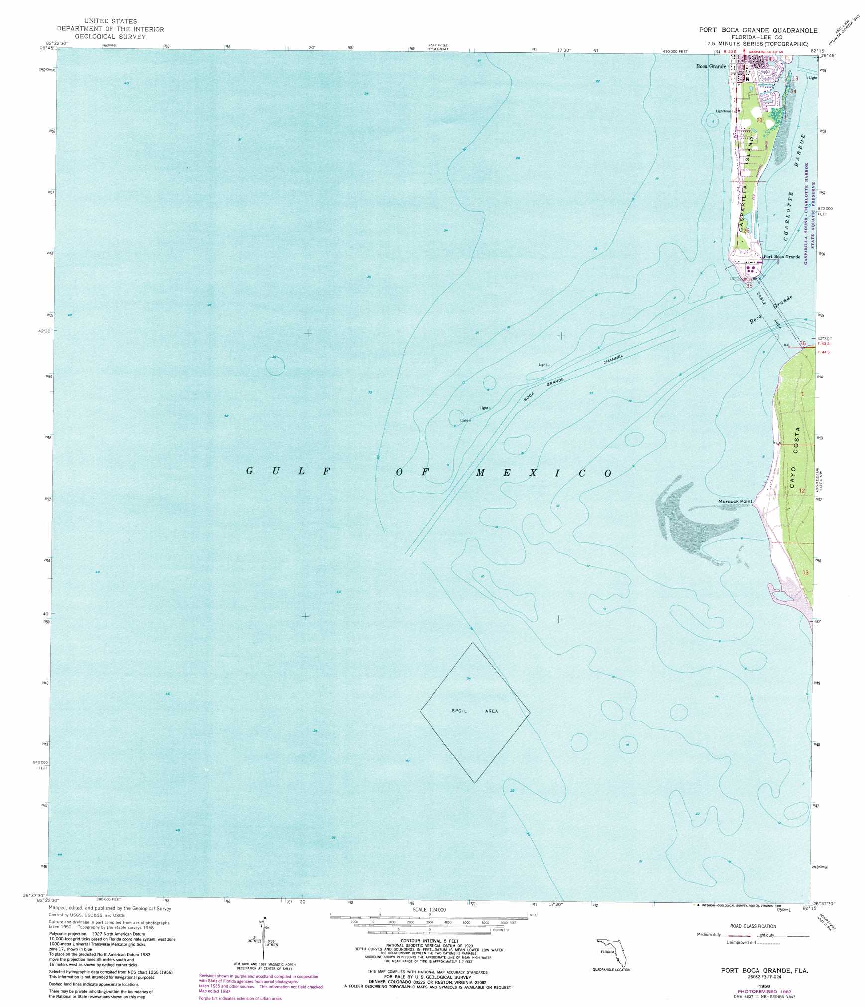
Port Boca Grande Topo Map Florida
To zoom in, hover over the map of Port Boca Grande
USGS Topo Quad 26082f3 - 1:24,000 scale
| Topo Map Name: | Port Boca Grande |
| USGS Topo Quad ID: | 26082f3 |
| Print Size: | ca. 21 1/4" wide x 27" high |
| Southeast Coordinates: | 26.625° N latitude / 82.25° W longitude |
| Map Center Coordinates: | 26.6875° N latitude / 82.3125° W longitude |
| U.S. State: | FL |
| Filename: | O26082F3.jpg |
| Download Map JPG Image: | Port Boca Grande topo map 1:24,000 scale |
| Map Type: | Topographic |
| Topo Series: | 7.5´ |
| Map Scale: | 1:24,000 |
| Source of Map Images: | United States Geological Survey (USGS) |
| Alternate Map Versions: |
Port Boca Grande FL 1958, updated 1959 Download PDF Buy paper map Port Boca Grande FL 1958, updated 1969 Download PDF Buy paper map Port Boca Grande FL 1958, updated 1973 Download PDF Buy paper map Port Boca Grande FL 1958, updated 1977 Download PDF Buy paper map Port Boca Grande FL 1958, updated 1988 Download PDF Buy paper map Port Boca Grande FL 2012 Download PDF Buy paper map Port Boca Grande FL 2015 Download PDF Buy paper map |
1:24,000 Topo Quads surrounding Port Boca Grande
Englewood Nw |
Englewood |
El Jobean |
Punta Gorda |
|
Placida |
Punta Gorda Sw |
Punta Gorda Se |
||
Port Boca Grande |
Bokeelia |
Matlacha |
||
Captiva |
Pine Island Center |
|||
Wulfert |
Sanibel |
> Back to 26082e1 at 1:100,000 scale
> Back to 26082a1 at 1:250,000 scale
> Back to U.S. Topo Maps home
Port Boca Grande topo map: Gazetteer
Port Boca Grande: Airports
Boca Grande Helistop elevation 1m 3′Port Boca Grande: Bars
Johnson Shoals elevation 0m 0′Port Boca Grande: Capes
Murdock Point elevation 0m 0′Port Boca Grande: Channels
Boca Grande elevation 0m 0′Boca Grande Channel elevation 0m 0′
Port Boca Grande: Parks
Gasparilla Island State Park elevation 1m 3′Port Boca Grande: Populated Places
Boca Grande elevation 1m 3′Port Boca Grande elevation 0m 0′
Port Boca Grande digital topo map on disk
Buy this Port Boca Grande topo map showing relief, roads, GPS coordinates and other geographical features, as a high-resolution digital map file on DVD: