Punta Gorda Se Topo Map Florida
To zoom in, hover over the map of Punta Gorda Se
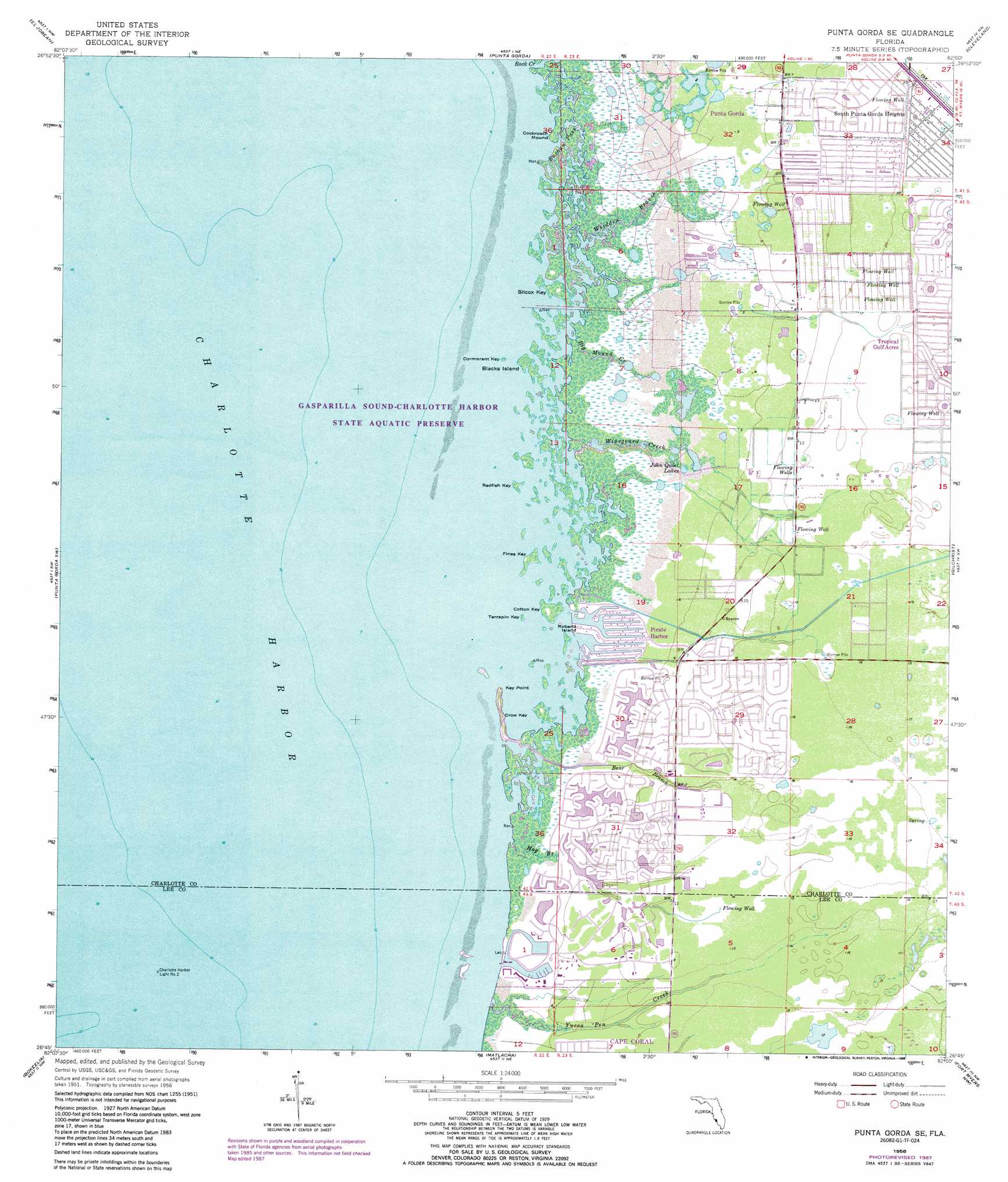
USGS Topo Quad 26082g1 - 1:24,000 scale
| Topo Map Name: | Punta Gorda Se |
| USGS Topo Quad ID: | 26082g1 |
| Print Size: | ca. 21 1/4" wide x 27" high |
| Southeast Coordinates: | 26.75° N latitude / 82° W longitude |
| Map Center Coordinates: | 26.8125° N latitude / 82.0625° W longitude |
| U.S. State: | FL |
| Filename: | O26082G1.jpg |
| Download Map JPG Image: | Punta Gorda Se topo map 1:24,000 scale |
| Map Type: | Topographic |
| Topo Series: | 7.5´ |
| Map Scale: | 1:24,000 |
| Source of Map Images: | United States Geological Survey (USGS) |
| Alternate Map Versions: |
Punta Gorda SE FL 1956, updated 1957 Download PDF Buy paper map Punta Gorda SE FL 1956, updated 1965 Download PDF Buy paper map Punta Gorda SE FL 1956, updated 1972 Download PDF Buy paper map Punta Gorda SE FL 1956, updated 1973 Download PDF Buy paper map Punta Gorda Se FL 1956, updated 1988 Download PDF Buy paper map Punta Gorda SE FL 2012 Download PDF Buy paper map Punta Gorda SE FL 2015 Download PDF Buy paper map |
1:24,000 Topo Quads surrounding Punta Gorda Se
Myakka River |
Murdock |
Murdock Se |
Fort Ogden |
Arcadia Se |
Englewood |
El Jobean |
Punta Gorda |
Cleveland |
Bermont |
Placida |
Punta Gorda Sw |
Punta Gorda Se |
Gilchrist |
Tuckers Corner |
Port Boca Grande |
Bokeelia |
Matlacha |
Fort Myers Nw |
Fort Myers |
Captiva |
Pine Island Center |
Fort Myers Sw |
Fort Myers Se |
> Back to 26082e1 at 1:100,000 scale
> Back to 26082a1 at 1:250,000 scale
> Back to U.S. Topo Maps home
Punta Gorda Se topo map: Gazetteer
Punta Gorda Se: Capes
Cockroach Mound elevation 0m 0′Key Point elevation 0m 0′
Punta Gorda Se: Channels
Buchau Pass elevation 0m 0′Punta Gorda Se: Guts
Rock Creek elevation 0m 0′Punta Gorda Se: Islands
Blacks Island elevation 0m 0′Cormorant Key elevation 0m 0′
Cotton Key elevation 0m 0′
Crow Key elevation 0m 0′
Fines Key elevation 0m 0′
Redfish Key elevation 0m 0′
Roberts Island elevation 0m 0′
Silcox Key elevation 0m 0′
Terrapin Key elevation 0m 0′
Punta Gorda Se: Lakes
John Quiet Lakes elevation 1m 3′Punta Gorda Se: Populated Places
Burnt Store Colony Mobile Home Park elevation 3m 9′Burnt Store Marina elevation 2m 6′
Pirate Harbor elevation 0m 0′
Punta Gorda Se: Streams
Bear Branch elevation 0m 0′Big Mound Creek elevation 0m 0′
Hog Branch elevation 0m 0′
Whidden Branch elevation 0m 0′
Winegourd Creek elevation 0m 0′
Yucca Pen Creek elevation 0m 0′
Punta Gorda Se digital topo map on disk
Buy this Punta Gorda Se topo map showing relief, roads, GPS coordinates and other geographical features, as a high-resolution digital map file on DVD: