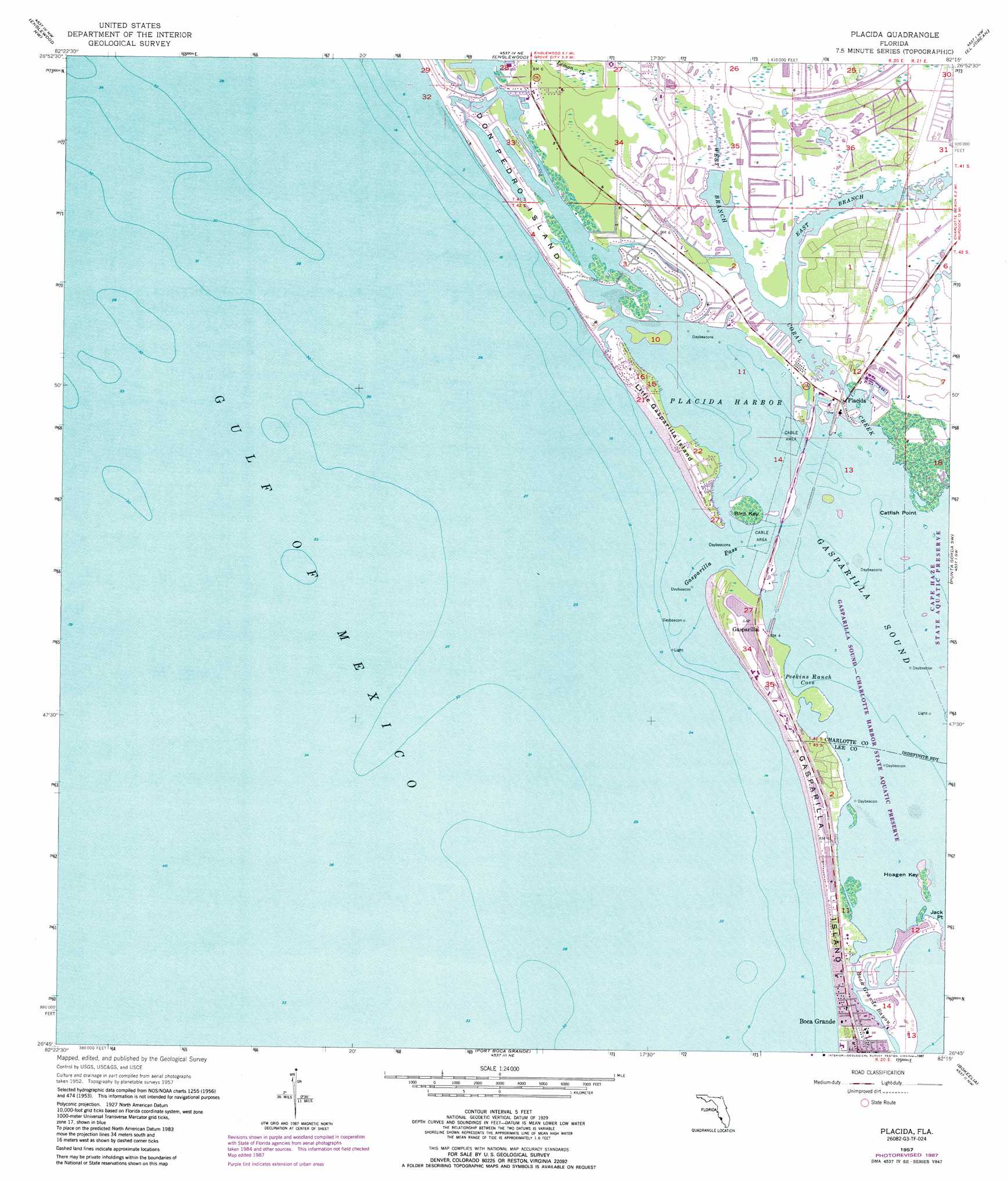
Placida Topo Map Florida
To zoom in, hover over the map of Placida
USGS Topo Quad 26082g3 - 1:24,000 scale
| Topo Map Name: | Placida |
| USGS Topo Quad ID: | 26082g3 |
| Print Size: | ca. 21 1/4" wide x 27" high |
| Southeast Coordinates: | 26.75° N latitude / 82.25° W longitude |
| Map Center Coordinates: | 26.8125° N latitude / 82.3125° W longitude |
| U.S. State: | FL |
| Filename: | O26082G3.jpg |
| Download Map JPG Image: | Placida topo map 1:24,000 scale |
| Map Type: | Topographic |
| Topo Series: | 7.5´ |
| Map Scale: | 1:24,000 |
| Source of Map Images: | United States Geological Survey (USGS) |
| Alternate Map Versions: |
Placida FL 1957, updated 1958 Download PDF Buy paper map Placida FL 1957, updated 1968 Download PDF Buy paper map Placida FL 1957, updated 1973 Download PDF Buy paper map Placida FL 1957, updated 1987 Download PDF Buy paper map Placida FL 2012 Download PDF Buy paper map Placida FL 2015 Download PDF Buy paper map |
1:24,000 Topo Quads surrounding Placida
Venice |
Myakka River |
Murdock |
Murdock Se |
|
Englewood Nw |
Englewood |
El Jobean |
Punta Gorda |
|
Placida |
Punta Gorda Sw |
Punta Gorda Se |
||
Port Boca Grande |
Bokeelia |
Matlacha |
||
Captiva |
Pine Island Center |
> Back to 26082e1 at 1:100,000 scale
> Back to 26082a1 at 1:250,000 scale
> Back to U.S. Topo Maps home
Placida topo map: Gazetteer
Placida: Airports
Rotonda International Airport elevation 1m 3′Placida: Bays
Blue Heron Cove elevation 0m 0′Gasparilla Sound elevation 0m 0′
Peekins Ranch Cove elevation 0m 0′
Pelican Bay elevation 0m 0′
Placida Harbor elevation 0m 0′
Rambler Hole elevation 0m 0′
Placida: Canals
Amberjack Cove elevation 1m 3′Galleon Cove elevation 1m 3′
Placida: Capes
Catfish Point elevation 0m 0′Jack Point elevation 0m 0′
Placida: Channels
Gasparilla Pass elevation 0m 0′Placida: Guts
Boca Grande Bayou elevation 0m 0′Bocilla Inlet elevation 0m 0′
Captains Cut elevation 1m 3′
Little Gasparilla Pass (historical) elevation 0m 0′
Placida: Harbors
Kettle Harbor elevation 0m 0′Placida: Islands
Bird Key elevation 0m 0′Bocilla Island elevation 1m 3′
Don Pedro Island elevation 0m 0′
Gasparilla Island elevation 1m 3′
Hoagen Key elevation 0m 0′
Little Gasparilla Island elevation 1m 3′
Placida: Lakes
Coral Cove elevation 0m 0′Lemon Lake elevation 1m 3′
Placida: Parks
Don Pedro Island State Park elevation 1m 3′Placida: Populated Places
Cape Haze elevation 1m 3′Gasparilla elevation 1m 3′
Placida elevation 1m 3′
Rotunda-West elevation 1m 3′
Placida: Streams
Coral Creek elevation 0m 0′East Branch Coral Creek elevation 0m 0′
West Branch Coral Creek elevation 0m 0′
Placida digital topo map on disk
Buy this Placida topo map showing relief, roads, GPS coordinates and other geographical features, as a high-resolution digital map file on DVD: