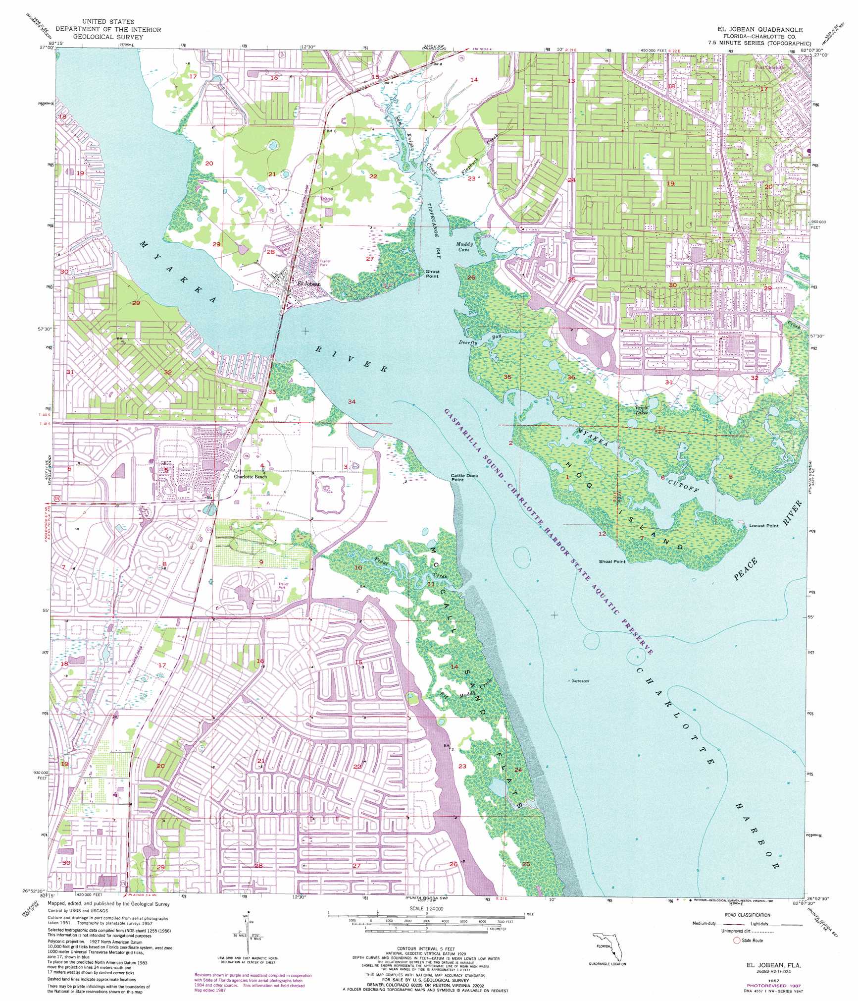
El Jobean Topo Map Florida
To zoom in, hover over the map of El Jobean
USGS Topo Quad 26082h2 - 1:24,000 scale
| Topo Map Name: | El Jobean |
| USGS Topo Quad ID: | 26082h2 |
| Print Size: | ca. 21 1/4" wide x 27" high |
| Southeast Coordinates: | 26.875° N latitude / 82.125° W longitude |
| Map Center Coordinates: | 26.9375° N latitude / 82.1875° W longitude |
| U.S. State: | FL |
| Filename: | O26082H2.jpg |
| Download Map JPG Image: | El Jobean topo map 1:24,000 scale |
| Map Type: | Topographic |
| Topo Series: | 7.5´ |
| Map Scale: | 1:24,000 |
| Source of Map Images: | United States Geological Survey (USGS) |
| Alternate Map Versions: |
El Jobean FL 1957, updated 1958 Download PDF Buy paper map El Jobean FL 1957, updated 1965 Download PDF Buy paper map El Jobean FL 1957, updated 1973 Download PDF Buy paper map El Jobean FL 1957, updated 1977 Download PDF Buy paper map El Jobean FL 1957, updated 1987 Download PDF Buy paper map El Jobean FL 2012 Download PDF Buy paper map El Jobean FL 2015 Download PDF Buy paper map |
1:24,000 Topo Quads surrounding El Jobean
Laurel |
Lower Myakka Lake |
Murdock Nw |
Murdock Ne |
Nocatee |
Venice |
Myakka River |
Murdock |
Murdock Se |
Fort Ogden |
Englewood Nw |
Englewood |
El Jobean |
Punta Gorda |
Cleveland |
Placida |
Punta Gorda Sw |
Punta Gorda Se |
Gilchrist |
|
Port Boca Grande |
Bokeelia |
Matlacha |
Fort Myers Nw |
> Back to 26082e1 at 1:100,000 scale
> Back to 26082a1 at 1:250,000 scale
> Back to U.S. Topo Maps home
El Jobean topo map: Gazetteer
El Jobean: Bays
Deerfly Bay elevation 0m 0′Muddy Cove elevation 0m 0′
Tippecanoe Bay elevation 0m 0′
El Jobean: Canals
Sioux Waterway elevation 1m 3′El Jobean: Capes
Cattle Dock Point elevation 0m 0′Ghost Point elevation 0m 0′
Locust Point elevation 0m 0′
Mangrove Point elevation 0m 0′
Point Lonesom elevation 0m 0′
Shoal Point elevation 0m 0′
El Jobean: Flats
McCall Sand Flats elevation 0m 0′El Jobean: Guts
Myakka Cutoff elevation 0m 0′El Jobean: Islands
Hog Island elevation 0m 0′El Jobean: Lakes
Triple Lakes elevation 0m 0′El Jobean: Populated Places
El Jobean elevation 2m 6′Harbor Lakes Mobile Home Park elevation 1m 3′
Vizcaya Lakes elevation 1m 3′
El Jobean: Streams
Big Muddy Creek elevation 0m 0′Flopbuck Creek elevation 0m 0′
Huckaby Creek elevation 0m 0′
Myakka River elevation 0m 0′
Peace River elevation 0m 0′
Sam Knight Creek elevation 0m 0′
Trout Creek elevation 0m 0′
El Jobean digital topo map on disk
Buy this El Jobean topo map showing relief, roads, GPS coordinates and other geographical features, as a high-resolution digital map file on DVD: