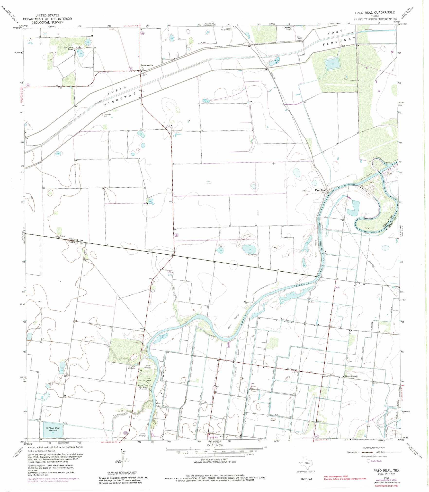
Paso Real Topo Map Texas
To zoom in, hover over the map of Paso Real
USGS Topo Quad 26097c5 - 1:24,000 scale
| Topo Map Name: | Paso Real |
| USGS Topo Quad ID: | 26097c5 |
| Print Size: | ca. 21 1/4" wide x 27" high |
| Southeast Coordinates: | 26.25° N latitude / 97.5° W longitude |
| Map Center Coordinates: | 26.3125° N latitude / 97.5625° W longitude |
| U.S. State: | TX |
| Filename: | o26097c5.jpg |
| Download Map JPG Image: | Paso Real topo map 1:24,000 scale |
| Map Type: | Topographic |
| Topo Series: | 7.5´ |
| Map Scale: | 1:24,000 |
| Source of Map Images: | United States Geological Survey (USGS) |
| Alternate Map Versions: |
Paso Real TX 1929 Download PDF Buy paper map Paso Real TX 1956, updated 1959 Download PDF Buy paper map Paso Real TX 1956, updated 1959 Download PDF Buy paper map Paso Real TX 1956, updated 1985 Download PDF Buy paper map Paso Real TX 2010 Download PDF Buy paper map Paso Real TX 2013 Download PDF Buy paper map Paso Real TX 2016 Download PDF Buy paper map |
1:24,000 Topo Quads surrounding Paso Real
Yturria |
San Perlita North |
El Jardin |
Port Mansfield |
South Of Potrero Lopeno Se |
Raymondville |
San Perlita South |
Willamar |
Hawk Island |
Green Island |
Santa Rosa |
Willamar Sw |
Paso Real |
La Leona |
Three Islands |
La Feria |
Harlingen |
Rio Hondo |
Laguna Atascosa |
La Coma |
Santa Maria |
La Paloma |
Olmito |
Los Fresnos |
Laguna Vista |
> Back to 26097a1 at 1:100,000 scale
> Back to 26096a1 at 1:250,000 scale
> Back to U.S. Topo Maps home
Paso Real topo map: Gazetteer
Paso Real: Dams
Cantwell Auxiliary Levee elevation 3m 9′Cantwell Main Levee elevation 3m 9′
Dry Reservoir Dam elevation 3m 9′
Hext Levee elevation 7m 22′
McCloud-Hood Levee elevation 8m 26′
Paso Real: Parks
Las Palomas Wildlife Management Area - Arroyo Colorado Unit elevation 4m 13′Paso Real: Populated Places
Laguna Escondida Colonia elevation 7m 22′Laguna Escondida Heights Number 2 Colonia elevation 6m 19′
Leisure Time Mobile Home Park Colonia elevation 7m 22′
Monte Grande elevation 3m 9′
Santa Monica elevation 5m 16′
Paso Real: Reservoirs
Cantwell Auxiliary Reservoir elevation 3m 9′Cantwell Main Reservoir elevation 3m 9′
Dry Reservoir elevation 3m 9′
Hext Reservoir elevation 7m 22′
McCloud Hood Reservoir elevation 10m 32′
Paso Real digital topo map on disk
Buy this Paso Real topo map showing relief, roads, GPS coordinates and other geographical features, as a high-resolution digital map file on DVD: