Willamar Topo Map Texas
To zoom in, hover over the map of Willamar
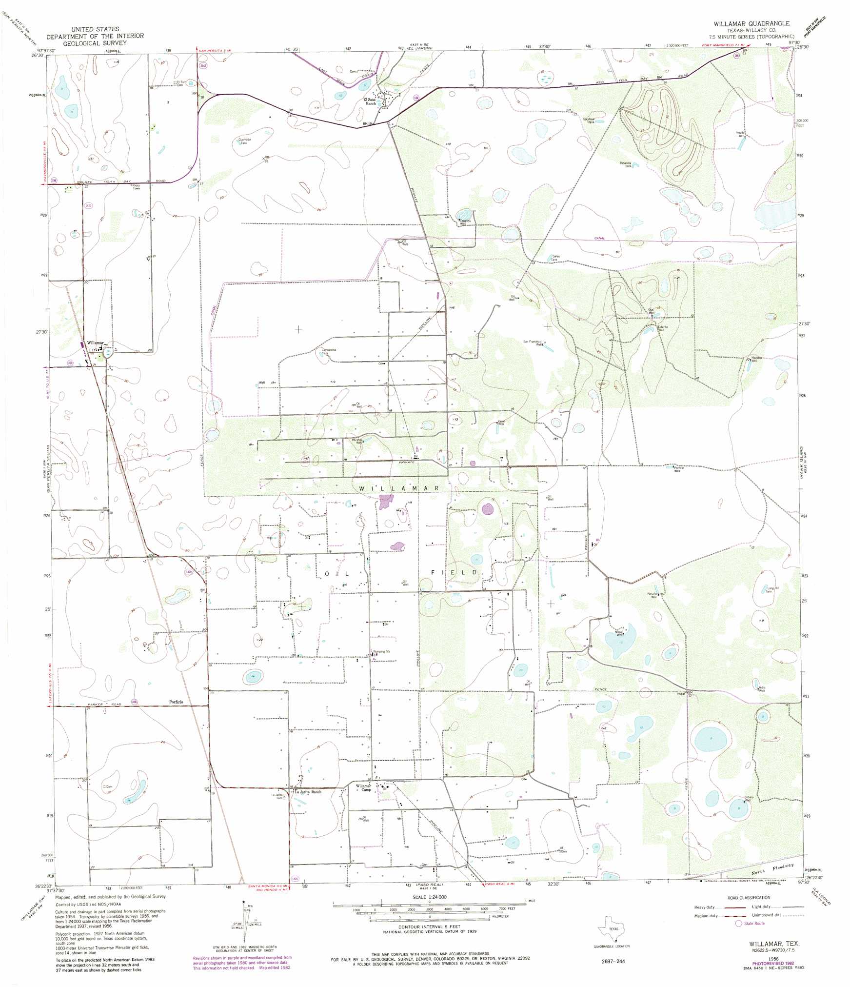
USGS Topo Quad 26097d5 - 1:24,000 scale
| Topo Map Name: | Willamar |
| USGS Topo Quad ID: | 26097d5 |
| Print Size: | ca. 21 1/4" wide x 27" high |
| Southeast Coordinates: | 26.375° N latitude / 97.5° W longitude |
| Map Center Coordinates: | 26.4375° N latitude / 97.5625° W longitude |
| U.S. State: | TX |
| Filename: | o26097d5.jpg |
| Download Map JPG Image: | Willamar topo map 1:24,000 scale |
| Map Type: | Topographic |
| Topo Series: | 7.5´ |
| Map Scale: | 1:24,000 |
| Source of Map Images: | United States Geological Survey (USGS) |
| Alternate Map Versions: |
Willamar TX 1956, updated 1958 Download PDF Buy paper map Willamar TX 1956, updated 1971 Download PDF Buy paper map Willamar TX 1956, updated 1984 Download PDF Buy paper map Willamar TX 2010 Download PDF Buy paper map Willamar TX 2013 Download PDF Buy paper map Willamar TX 2016 Download PDF Buy paper map |
1:24,000 Topo Quads surrounding Willamar
Rudolph |
Rosita Lake |
Rosita Lake Ne |
South Of Potrero Lopeno Nw |
South Of Potrero Lopeno Ne |
Yturria |
San Perlita North |
El Jardin |
Port Mansfield |
South Of Potrero Lopeno Se |
Raymondville |
San Perlita South |
Willamar |
Hawk Island |
Green Island |
Santa Rosa |
Willamar Sw |
Paso Real |
La Leona |
Three Islands |
La Feria |
Harlingen |
Rio Hondo |
Laguna Atascosa |
La Coma |
> Back to 26097a1 at 1:100,000 scale
> Back to 26096a1 at 1:250,000 scale
> Back to U.S. Topo Maps home
Willamar topo map: Gazetteer
Willamar: Oilfields
Willamar Oil Field elevation 6m 19′Willamar: Populated Places
Porfirio elevation 6m 19′Willamar elevation 6m 19′
Willamar: Reservoirs
Lampasosa Tank elevation 4m 13′Long Hill Tank elevation 3m 9′
Quemada Tank elevation 4m 13′
Retamita Tank elevation 4m 13′
Sacatosa Tank elevation 3m 9′
Willamar: Wells
Cabellos Well elevation 3m 9′Cebalo Well elevation 3m 9′
Esterita Well elevation 4m 13′
Gus Well elevation 5m 16′
Madama Well elevation 3m 9′
Mulatos Well elevation 4m 13′
Nopal Well elevation 4m 13′
Panalto Well elevation 4m 13′
Porfirio Well elevation 4m 13′
Precifa Well elevation 3m 9′
San Francisco Well elevation 4m 13′
Vacas Well elevation 4m 13′
Willamar digital topo map on disk
Buy this Willamar topo map showing relief, roads, GPS coordinates and other geographical features, as a high-resolution digital map file on DVD: