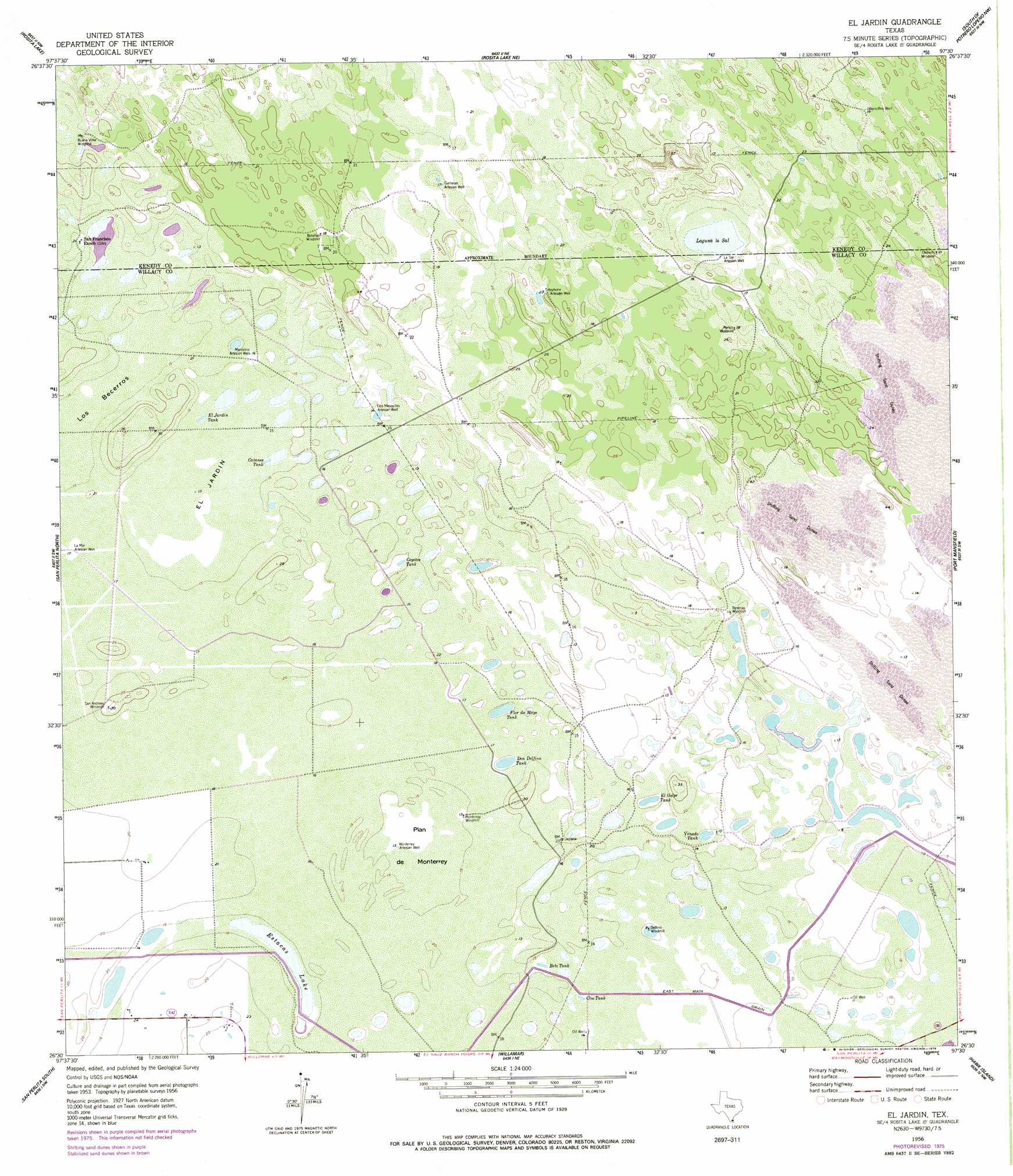
El Jardin Topo Map Texas
To zoom in, hover over the map of El Jardin
USGS Topo Quad 26097e5 - 1:24,000 scale
| Topo Map Name: | El Jardin |
| USGS Topo Quad ID: | 26097e5 |
| Print Size: | ca. 21 1/4" wide x 27" high |
| Southeast Coordinates: | 26.5° N latitude / 97.5° W longitude |
| Map Center Coordinates: | 26.5625° N latitude / 97.5625° W longitude |
| U.S. State: | TX |
| Filename: | o26097e5.jpg |
| Download Map JPG Image: | El Jardin topo map 1:24,000 scale |
| Map Type: | Topographic |
| Topo Series: | 7.5´ |
| Map Scale: | 1:24,000 |
| Source of Map Images: | United States Geological Survey (USGS) |
| Alternate Map Versions: |
El Jardin TX 1956, updated 1958 Download PDF Buy paper map El Jardin TX 2010 Download PDF Buy paper map El Jardin TX 2013 Download PDF Buy paper map El Jardin TX 2016 Download PDF Buy paper map |
1:24,000 Topo Quads surrounding El Jardin
Norias |
Saltillo Well |
Los Amigos Windmill |
Potrero Lopeno Sw |
Potrero Lopino Se |
Rudolph |
Rosita Lake |
Rosita Lake Ne |
South Of Potrero Lopeno Nw |
South Of Potrero Lopeno Ne |
Yturria |
San Perlita North |
El Jardin |
Port Mansfield |
South Of Potrero Lopeno Se |
Raymondville |
San Perlita South |
Willamar |
Hawk Island |
Green Island |
Santa Rosa |
Willamar Sw |
Paso Real |
La Leona |
Three Islands |
> Back to 26097e1 at 1:100,000 scale
> Back to 26096a1 at 1:250,000 scale
> Back to U.S. Topo Maps home
El Jardin topo map: Gazetteer
El Jardin: Flats
El Jardin elevation 3m 9′Los Becerros elevation 3m 9′
Plan de Monterrey elevation 4m 13′
El Jardin: Lakes
Estacas Lake elevation 4m 13′Laguna la Sal elevation 2m 6′
El Jardin: Reservoirs
Beto Tank elevation 3m 9′Catanes Tank elevation 4m 13′
Cleo Tank elevation 3m 9′
Coyotes Tank elevation 4m 13′
Don Delfino Tank elevation 5m 16′
El Golpe Tank elevation 4m 13′
El Jardin Tank elevation 4m 13′
Flor de Mayo Tank elevation 5m 16′
Venado Tank elevation 4m 13′
El Jardin: Wells
Canteras Artesian Well elevation 6m 19′Dos Mesquites Artesian Well elevation 4m 13′
Jaboncillos Well elevation 6m 19′
La Mar Artesian Well elevation 5m 16′
La Sal Artesian Well elevation 2m 6′
Marcelina Artesian Well elevation 5m 16′
Monterrey Artesian Well elevation 4m 13′
Telephone Artesian Well elevation 6m 19′
El Jardin digital topo map on disk
Buy this El Jardin topo map showing relief, roads, GPS coordinates and other geographical features, as a high-resolution digital map file on DVD: