Sullivan City Topo Map Texas
To zoom in, hover over the map of Sullivan City
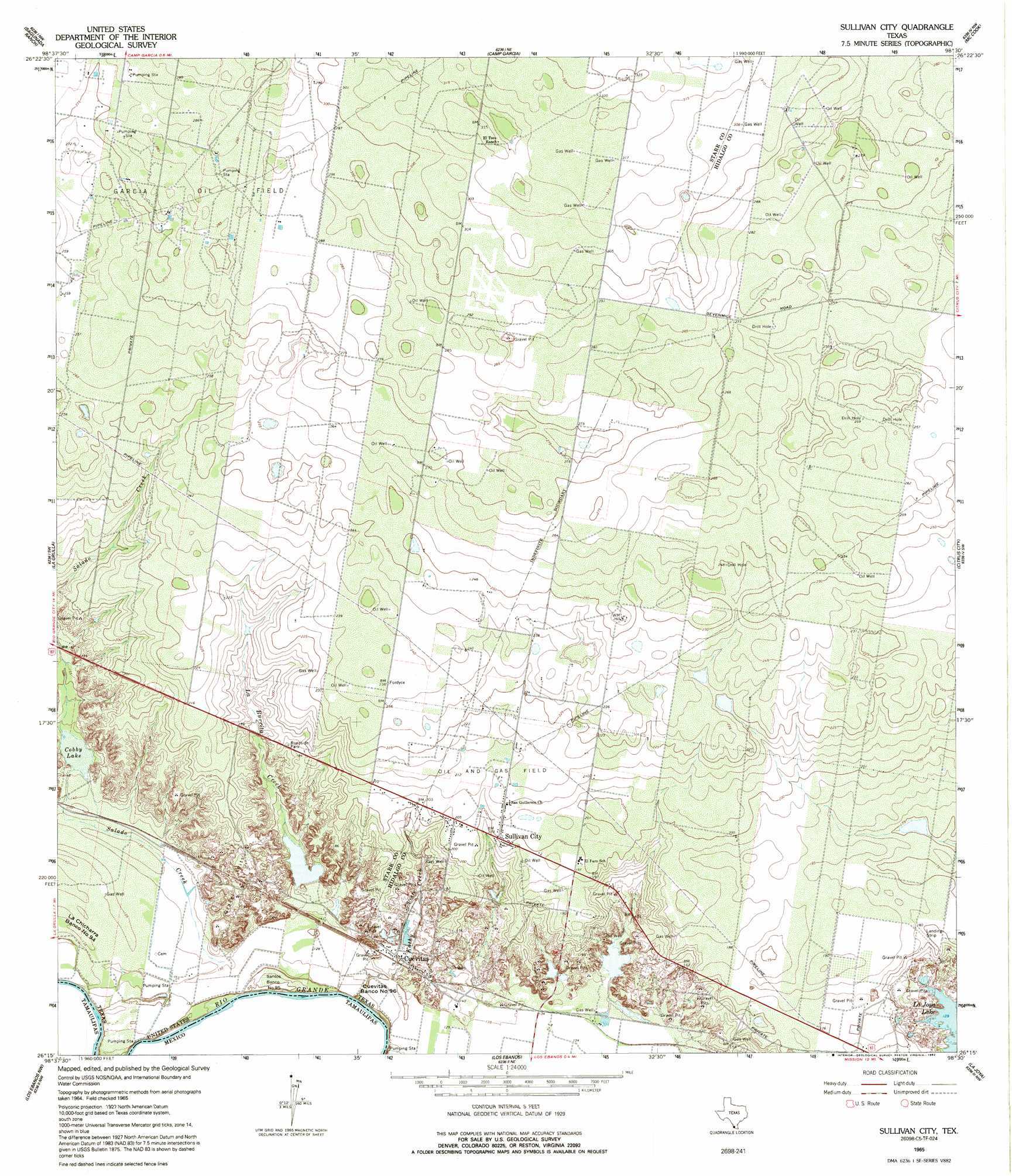
USGS Topo Quad 26098c5 - 1:24,000 scale
| Topo Map Name: | Sullivan City |
| USGS Topo Quad ID: | 26098c5 |
| Print Size: | ca. 21 1/4" wide x 27" high |
| Southeast Coordinates: | 26.25° N latitude / 98.5° W longitude |
| Map Center Coordinates: | 26.3125° N latitude / 98.5625° W longitude |
| U.S. State: | TX |
| Filename: | o26098c5.jpg |
| Download Map JPG Image: | Sullivan City topo map 1:24,000 scale |
| Map Type: | Topographic |
| Topo Series: | 7.5´ |
| Map Scale: | 1:24,000 |
| Source of Map Images: | United States Geological Survey (USGS) |
| Alternate Map Versions: |
Sullivan City TX 1965, updated 1968 Download PDF Buy paper map Sullivan City TX 1965, updated 1992 Download PDF Buy paper map Sullivan City TX 2002, updated 2003 Download PDF Buy paper map Sullivan City TX 2010 Download PDF Buy paper map Sullivan City TX 2013 Download PDF Buy paper map Sullivan City TX 2016 Download PDF Buy paper map |
1:24,000 Topo Quads surrounding Sullivan City
El Sauz |
La Gloria Sw |
Rincon |
Bentsen Ranch |
Mcallen Ranch |
Rio Grande City North |
Sagunada Ranch |
Camp Garcia |
Mccook |
Monte Christo |
Rio Grande City South |
La Grulla |
Sullivan City |
Citrus City |
Alton |
Los Ebanos Nw |
Los Ebanos |
La Joya |
Mission |
|
Hidalgo |
> Back to 26098a1 at 1:100,000 scale
> Back to 26098a1 at 1:250,000 scale
> Back to U.S. Topo Maps home
Sullivan City topo map: Gazetteer
Sullivan City: Lakes
Cobby Lake elevation 42m 137′Sullivan City: Levees
Cuevitas Banco Number 96 elevation 40m 131′Santos Banco Number 95 elevation 39m 127′
Sullivan City: Populated Places
Benavides Colonia Number 2 elevation 63m 206′Benevides Colonia elevation 59m 193′
Blue Star Enterprises Number 2 Colonia elevation 67m 219′
Buena Vista Colonia elevation 60m 196′
Colonia Rafael elevation 63m 206′
Colonia San Miguel elevation 58m 190′
Cuevitas elevation 43m 141′
La Aurora Colonia elevation 57m 187′
La Hermosa Colonia elevation 60m 196′
Las Cuevas Colonia elevation 62m 203′
Las Cuevas Number 2 Colonia elevation 62m 203′
Nina Colonia elevation 61m 200′
Quesada Colonia elevation 62m 203′
Rancho Colonia elevation 75m 246′
Saint Clair Acres Colonia elevation 58m 190′
Saint Claire Fisher Colonia elevation 61m 200′
Sullivan City elevation 61m 200′
Vales Colonia elevation 59m 193′
Valle Vista Colonia elevation 76m 249′
Villa Estates Colonia elevation 56m 183′
Sullivan City: Streams
Kathy Creek elevation 38m 124′La Burrita Creek elevation 42m 137′
Sullivan City digital topo map on disk
Buy this Sullivan City topo map showing relief, roads, GPS coordinates and other geographical features, as a high-resolution digital map file on DVD: