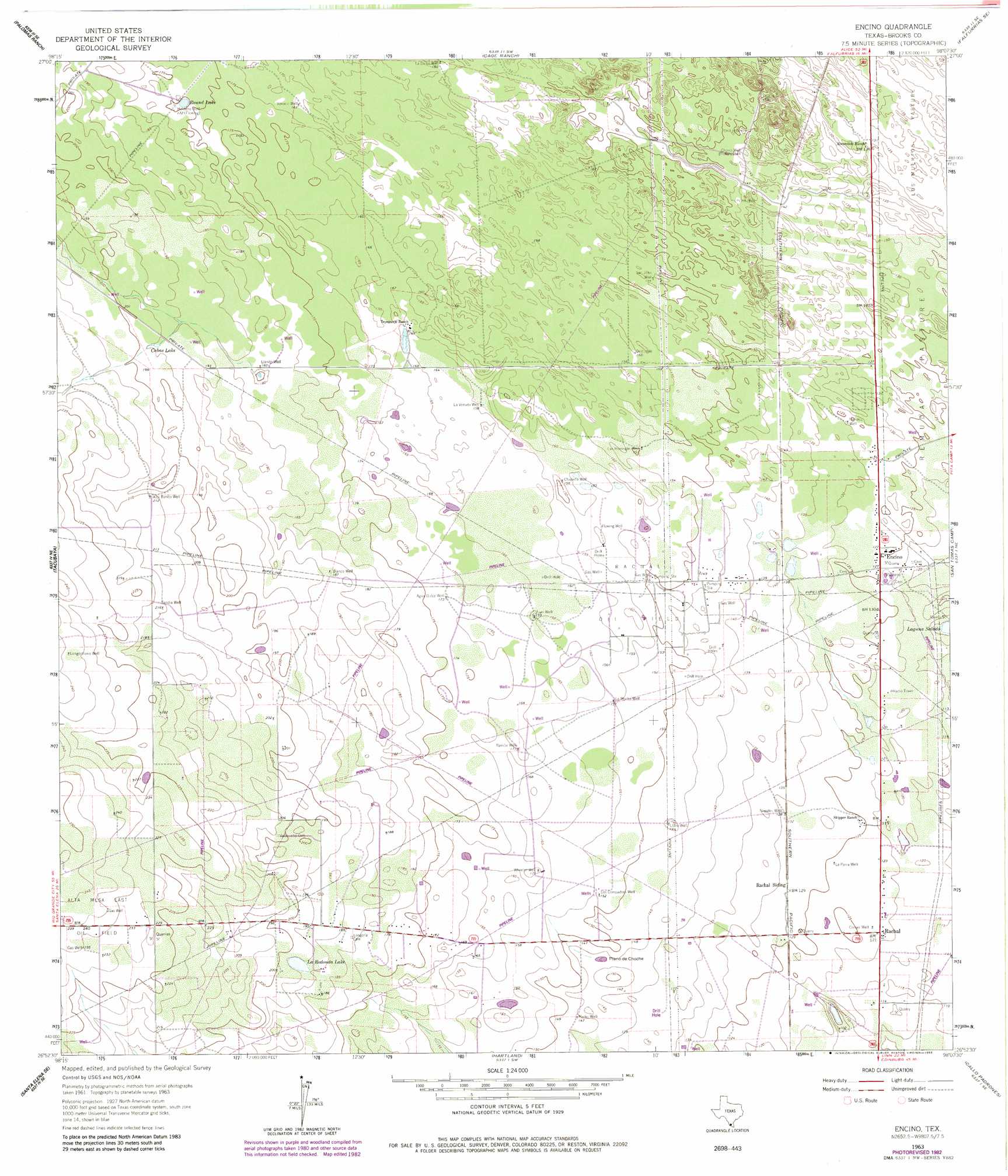
Encino Topo Map Texas
To zoom in, hover over the map of Encino
USGS Topo Quad 26098h2 - 1:24,000 scale
| Topo Map Name: | Encino |
| USGS Topo Quad ID: | 26098h2 |
| Print Size: | ca. 21 1/4" wide x 27" high |
| Southeast Coordinates: | 26.875° N latitude / 98.125° W longitude |
| Map Center Coordinates: | 26.9375° N latitude / 98.1875° W longitude |
| U.S. State: | TX |
| Filename: | o26098h2.jpg |
| Download Map JPG Image: | Encino topo map 1:24,000 scale |
| Map Type: | Topographic |
| Topo Series: | 7.5´ |
| Map Scale: | 1:24,000 |
| Source of Map Images: | United States Geological Survey (USGS) |
| Alternate Map Versions: |
Encino TX 1963, updated 1965 Download PDF Buy paper map Encino TX 1963, updated 1983 Download PDF Buy paper map Encino TX 2010 Download PDF Buy paper map Encino TX 2012 Download PDF Buy paper map Encino TX 2016 Download PDF Buy paper map |
1:24,000 Topo Quads surrounding Encino
Palomas Ranch Nw |
Palomas Ranch |
Falfurrias |
Flowella |
La Paloma Ranch |
Palomas Ranch Sw |
Palomas Ranch Se |
Cage Ranch |
Falfurrias Se |
Sarita Sw |
Santa Elena Nw |
Tacubaya |
Encino |
San Tomas Camp |
Pita Camp |
Santa Elena |
Santa Elena Se |
Hartland |
Callo Padrones |
Julian |
San Isidro |
La Reforma |
Linn Nw |
Linn Ne |
Andrea Ranch |
> Back to 26098e1 at 1:100,000 scale
> Back to 26098a1 at 1:250,000 scale
> Back to U.S. Topo Maps home
Encino topo map: Gazetteer
Encino: Areas
Plano de Choche elevation 44m 144′Encino: Lakes
La Redonda Lake elevation 59m 193′Round Lake elevation 53m 173′
Encino: Oilfields
Alta Mesa East Oil Field elevation 73m 239′Rachal Oil Field elevation 47m 154′
Encino: Populated Places
Encino elevation 38m 124′Rachal elevation 37m 121′
Encino: Reservoirs
Cabas Lake elevation 59m 193′Medio Lake elevation 63m 206′
Encino: Wells
Agua Dulce Well elevation 53m 173′Alto Bonito Well elevation 64m 209′
Blanco Well elevation 57m 187′
Chapeno Well elevation 47m 154′
Chorro Well elevation 44m 144′
Corner Well elevation 37m 121′
Heldeno Well elevation 53m 173′
Juan Well elevation 48m 157′
La Dicha Well elevation 49m 160′
La Mocha Well elevation 47m 154′
La Parra Well elevation 38m 124′
La Venada Well elevation 49m 160′
Las Hormigas Well elevation 46m 150′
Llanito Well elevation 55m 180′
Llano Well elevation 44m 144′
Longorlliano Well elevation 73m 239′
Los Compadres Well elevation 47m 154′
Medio Well elevation 45m 147′
Narvaez Well elevation 39m 127′
Nogales Well elevation 39m 127′
Ramon Well elevation 52m 170′
San Juan Well elevation 47m 154′
Sandia Well elevation 66m 216′
Venado Well elevation 51m 167′
Wheeler Well elevation 52m 170′
Encino digital topo map on disk
Buy this Encino topo map showing relief, roads, GPS coordinates and other geographical features, as a high-resolution digital map file on DVD: