Saint Lucie Inlet Topo Map Florida
To zoom in, hover over the map of Saint Lucie Inlet
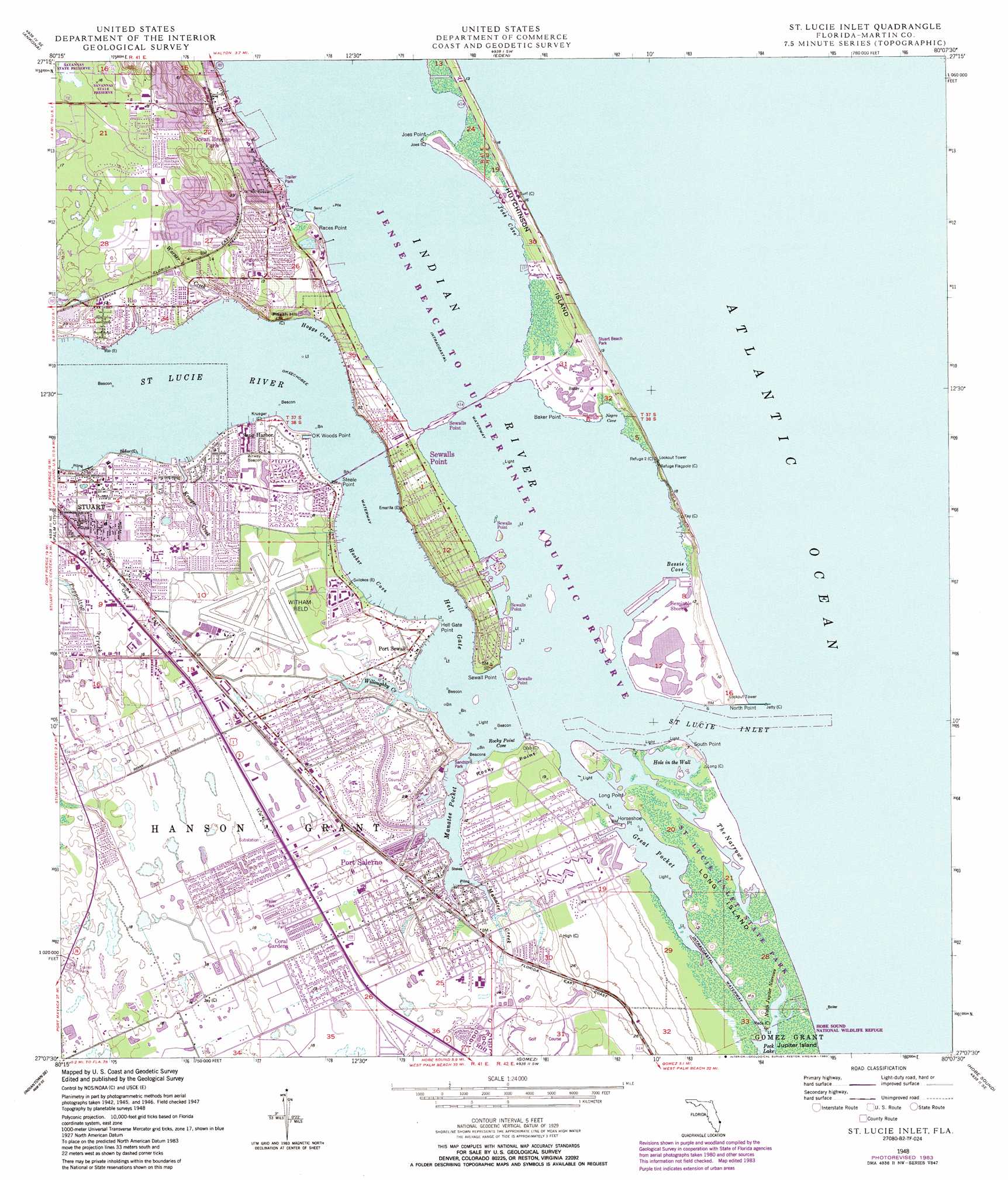
USGS Topo Quad 27080b2 - 1:24,000 scale
| Topo Map Name: | Saint Lucie Inlet |
| USGS Topo Quad ID: | 27080b2 |
| Print Size: | ca. 21 1/4" wide x 27" high |
| Southeast Coordinates: | 27.125° N latitude / 80.125° W longitude |
| Map Center Coordinates: | 27.1875° N latitude / 80.1875° W longitude |
| U.S. State: | FL |
| Filename: | O27080B2.jpg |
| Download Map JPG Image: | Saint Lucie Inlet topo map 1:24,000 scale |
| Map Type: | Topographic |
| Topo Series: | 7.5´ |
| Map Scale: | 1:24,000 |
| Source of Map Images: | United States Geological Survey (USGS) |
| Alternate Map Versions: |
St. Lucie Inlet FL 1948, updated 1958 Download PDF Buy paper map St. Lucie Inlet FL 1948, updated 1971 Download PDF Buy paper map St Lucie Inlet FL 1948, updated 1973 Download PDF Buy paper map St. Lucie Inlet FL 1948, updated 1983 Download PDF Buy paper map St. Lucie Inlet FL 1950 Download PDF Buy paper map Saint Lucie Inlet FL 2012 Download PDF Buy paper map Saint Lucie Inlet FL 2015 Download PDF Buy paper map |
1:24,000 Topo Quads surrounding Saint Lucie Inlet
Fort Pierce Nw |
Fort Pierce |
|||
Fort Pierce Sw |
Ankona |
Eden |
||
Indian Town Nw |
Palm City |
Saint Lucie Inlet |
||
Indian Town |
Indiantown Se |
Gomez |
Hobe Sound |
|
West Palm Beach 2 Nw |
West Palm Beach 2 Ne |
Rood |
Jupiter |
> Back to 27080a1 at 1:100,000 scale
> Back to 27080a1 at 1:250,000 scale
> Back to U.S. Topo Maps home
Saint Lucie Inlet topo map: Gazetteer
Saint Lucie Inlet: Airports
Martin Memorial Hospital Heliport elevation 0m 0′Sailfish Point Heliport elevation 1m 3′
Witham Field elevation 4m 13′
Saint Lucie Inlet: Bars
Gilbert Shoal elevation 0m 0′Saint Lucie Inlet: Bays
Bessie Cove elevation 0m 0′Hoggs Cove elevation 0m 0′
Hooker Cove elevation 0m 0′
Joes Cove elevation 0m 0′
Negro Cove elevation 0m 0′
Rocky Point Cove elevation 0m 0′
Saint Lucie Inlet: Bridges
Ernest Lyons Bridge elevation 0m 0′Evans McCrary Bridge elevation 0m 0′
Saint Lucie Inlet: Capes
Baker Point elevation 0m 0′Hell Gate Point elevation 2m 6′
Horseshoe Point elevation 0m 0′
Joes Point elevation 0m 0′
Long Point elevation 0m 0′
North Point elevation 0m 0′
OK Woods Point elevation 0m 0′
Rocky Point elevation 2m 6′
Sewall Point elevation 1m 3′
South Point elevation 0m 0′
Steele Point elevation 1m 3′
Saint Lucie Inlet: Channels
Hell Gate elevation 0m 0′Saint Lucie Inlet: Guts
Hole in the Wall elevation 0m 0′North Jupiter Narrows elevation 0m 0′
Saint Lucie Inlet elevation 0m 0′
The Narrows elevation 0m 0′
Willoughby Creek elevation 0m 0′
Saint Lucie Inlet: Islands
Long Island elevation 0m 0′Saint Lucie Inlet: Lakes
Great Pocket elevation 0m 0′Manatee Pocket elevation 0m 0′
Saint Lucie Inlet: Parks
Hobe Sound National Wildlife Refuge elevation 0m 0′Langlard Park elevation 3m 9′
Saint Lucie Inlet Preserve State Park elevation 0m 0′
Sandsprit Park elevation 2m 6′
Saint Lucie Inlet: Populated Places
Coral Gardens elevation 4m 13′Fruita elevation 7m 22′
Golden Gate elevation 4m 13′
Holiday Mobile Home Park elevation 3m 9′
Natalie Estates Mobile Home Park elevation 5m 16′
Ocean Breeze Park elevation 2m 6′
Open Gate Trailer Park elevation 5m 16′
Pinelake Village Mobile Home Park elevation 3m 9′
Port Salerno elevation 4m 13′
Port Sewall elevation 0m 0′
Rio elevation 1m 3′
Salerno Trailer Park elevation 4m 13′
Seminole Shores elevation 0m 0′
Sewall's Point elevation 6m 19′
Skyline Heights elevation 2m 6′
Snug Harbor elevation 2m 6′
Sunshine Mobile Manor elevation 5m 16′
Tropical Acres Mobile Home Park elevation 1m 3′
Saint Lucie Inlet: Post Offices
Port Sewall Post Office (historical) elevation 0m 0′Stuart Post Office elevation 1m 3′
Saint Lucie Inlet: Streams
Krueger Creek elevation 0m 0′Manatee Creek elevation 0m 0′
Saint Lucie River elevation 0m 0′
Warner Creek elevation 0m 0′
Saint Lucie Inlet: Summits
Pisgah Hill elevation 5m 16′Saint Lucie Inlet digital topo map on disk
Buy this Saint Lucie Inlet topo map showing relief, roads, GPS coordinates and other geographical features, as a high-resolution digital map file on DVD: