Okeechobee 4 Nw Topo Map Florida
To zoom in, hover over the map of Okeechobee 4 Nw
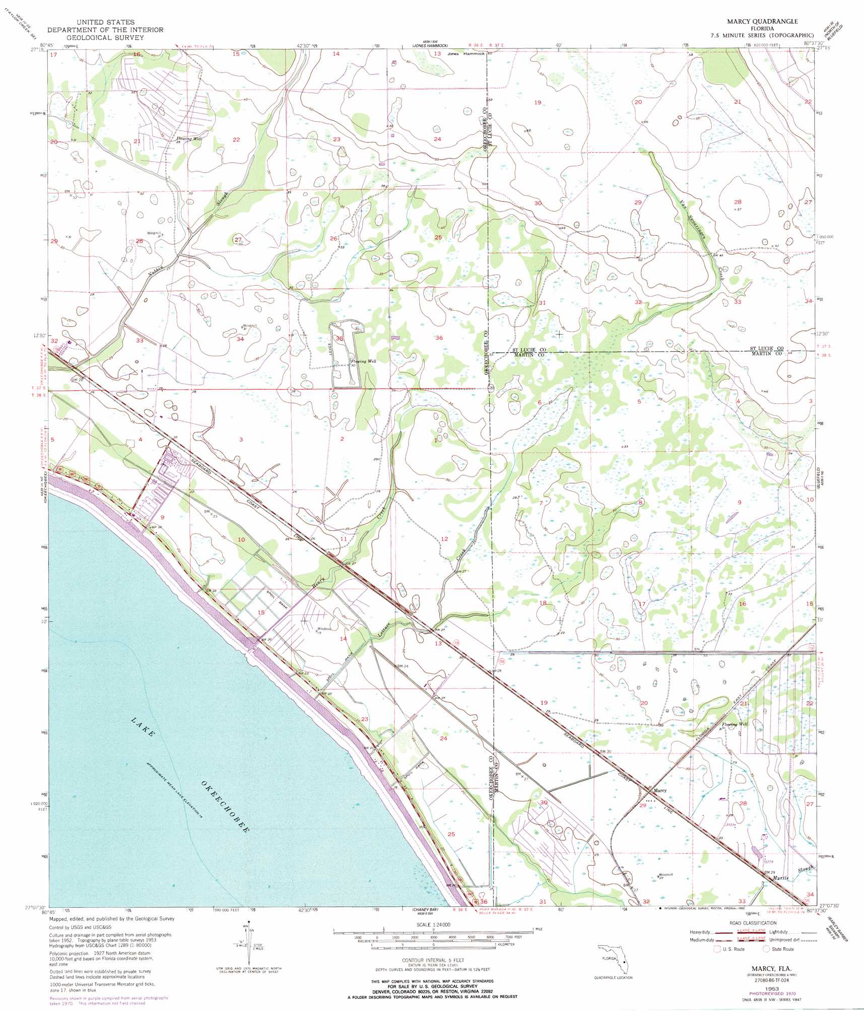
USGS Topo Quad 27080b6 - 1:24,000 scale
| Topo Map Name: | Okeechobee 4 Nw |
| USGS Topo Quad ID: | 27080b6 |
| Print Size: | ca. 21 1/4" wide x 27" high |
| Southeast Coordinates: | 27.125° N latitude / 80.625° W longitude |
| Map Center Coordinates: | 27.1875° N latitude / 80.6875° W longitude |
| U.S. State: | FL |
| Filename: | O27080B6.jpg |
| Download Map JPG Image: | Okeechobee 4 Nw topo map 1:24,000 scale |
| Map Type: | Topographic |
| Topo Series: | 7.5´ |
| Map Scale: | 1:24,000 |
| Source of Map Images: | United States Geological Survey (USGS) |
| Alternate Map Versions: |
Okeechobee 4 NW FL 1953, updated 1954 Download PDF Buy paper map Okeechobee 4 NW FL 1953, updated 1969 Download PDF Buy paper map Okeechobee 4 NW FL 1953, updated 1971 Download PDF Buy paper map Marcy FL 1953, updated 1993 Download PDF Buy paper map Marcy FL 2012 Download PDF Buy paper map Marcy FL 2015 Download PDF Buy paper map |
1:24,000 Topo Quads surrounding Okeechobee 4 Nw
Taylor Creek Nw |
Taylor Creek Ne |
Okeechobee 1 Nw |
Okeechobee 1 Ne |
Fort Pierce Nw |
Taylor Creek Sw |
Taylor Creek Se |
Okeechobee 1 Sw |
Okeechobee 1 Se |
Fort Pierce Sw |
Okeechobee Nw |
Okeechobee |
Okeechobee 4 Nw |
Okeechobee 4 Ne |
Indian Town Nw |
Okeechobee Sw |
Okeechobee Se |
Okeechobee 4 Sw |
Okeechobee 4 Se |
Indian Town |
Cochrans Pass |
Port Mayaca |
West Palm Beach 2 Nw |
> Back to 27080a1 at 1:100,000 scale
> Back to 27080a1 at 1:250,000 scale
> Back to U.S. Topo Maps home
Okeechobee 4 Nw topo map: Gazetteer
Okeechobee 4 Nw: Guts
Van Swearingen Creek elevation 13m 42′Okeechobee 4 Nw: Populated Places
Happy Hour Park Mobile Home Park elevation 5m 16′Katies Korner Mobile Home Park elevation 6m 19′
Marcy elevation 9m 29′
Up the Grove Beach elevation 4m 13′
Okeechobee 4 Nw: Streams
Henry Creek elevation 5m 16′Lettuce Creek elevation 4m 13′
Okeechobee 4 Nw digital topo map on disk
Buy this Okeechobee 4 Nw topo map showing relief, roads, GPS coordinates and other geographical features, as a high-resolution digital map file on DVD: