Fort Drum Sw Topo Map Florida
To zoom in, hover over the map of Fort Drum Sw
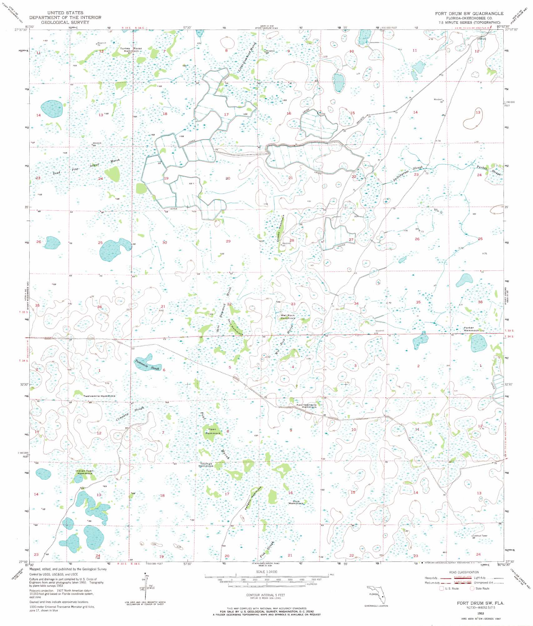
USGS Topo Quad 27080e8 - 1:24,000 scale
| Topo Map Name: | Fort Drum Sw |
| USGS Topo Quad ID: | 27080e8 |
| Print Size: | ca. 21 1/4" wide x 27" high |
| Southeast Coordinates: | 27.5° N latitude / 80.875° W longitude |
| Map Center Coordinates: | 27.5625° N latitude / 80.9375° W longitude |
| U.S. State: | FL |
| Filename: | O27080E8.jpg |
| Download Map JPG Image: | Fort Drum Sw topo map 1:24,000 scale |
| Map Type: | Topographic |
| Topo Series: | 7.5´ |
| Map Scale: | 1:24,000 |
| Source of Map Images: | United States Geological Survey (USGS) |
| Alternate Map Versions: |
Fort Drum SW FL 1953, updated 1954 Download PDF Buy paper map Fort Drum SW FL 1953, updated 1971 Download PDF Buy paper map Fort Drum SW FL 1953, updated 1972 Download PDF Buy paper map Fort Drum SW FL 2012 Download PDF Buy paper map Fort Drum SW FL 2015 Download PDF Buy paper map |
1:24,000 Topo Quads surrounding Fort Drum Sw
Lake Marian Sw |
Lake Marian Se |
Kenansville Sw |
Kenansville Se |
Fellsmere Sw |
Fort Kissimmee Nw |
Fort Kissimmee Ne |
Fort Drum Nw |
Fort Drum Ne |
Fellsmere 4 Nw |
Fort Kissimmee |
Fort Kissimmee Se |
Fort Drum Sw |
Fort Drum |
Fellsmere 4 Sw |
Basinger Nw |
Basinger |
Taylor Creek Nw |
Taylor Creek Ne |
Okeechobee 1 Nw |
Basinger Sw |
Fort Basinger |
Taylor Creek Sw |
Taylor Creek Se |
Okeechobee 1 Sw |
> Back to 27080e1 at 1:100,000 scale
> Back to 27080a1 at 1:250,000 scale
> Back to U.S. Topo Maps home
Fort Drum Sw topo map: Gazetteer
Fort Drum Sw: Guts
Switchgrass Slough elevation 21m 68′Fort Drum Sw: Islands
Crosby Hammock elevation 21m 68′Fourteenmile Hammock elevation 21m 68′
Indian Town Hammock elevation 21m 68′
Irvin Hammock elevation 21m 68′
Open Hammock elevation 21m 68′
Padgett Hammock elevation 21m 68′
Parker Hammock elevation 21m 68′
Shin Hammock elevation 21m 68′
Thomas Hammock elevation 21m 68′
Turkey Roost Hammock elevation 21m 68′
Twelvemile Hammock elevation 21m 68′
Wet Rock Hammock elevation 21m 68′
Fort Drum Sw: Lakes
Twelvemile Slough elevation 20m 65′Fort Drum Sw: Swamps
Company Slough elevation 21m 68′Dead Pine Island Marsh elevation 20m 65′
Little Gumhead Marsh elevation 21m 68′
Peat Marsh elevation 21m 68′
Shin Hammock Marsh elevation 21m 68′
Wet Rock Marsh elevation 21m 68′
Fort Drum Sw digital topo map on disk
Buy this Fort Drum Sw topo map showing relief, roads, GPS coordinates and other geographical features, as a high-resolution digital map file on DVD: