Vero Beach Topo Map Florida
To zoom in, hover over the map of Vero Beach
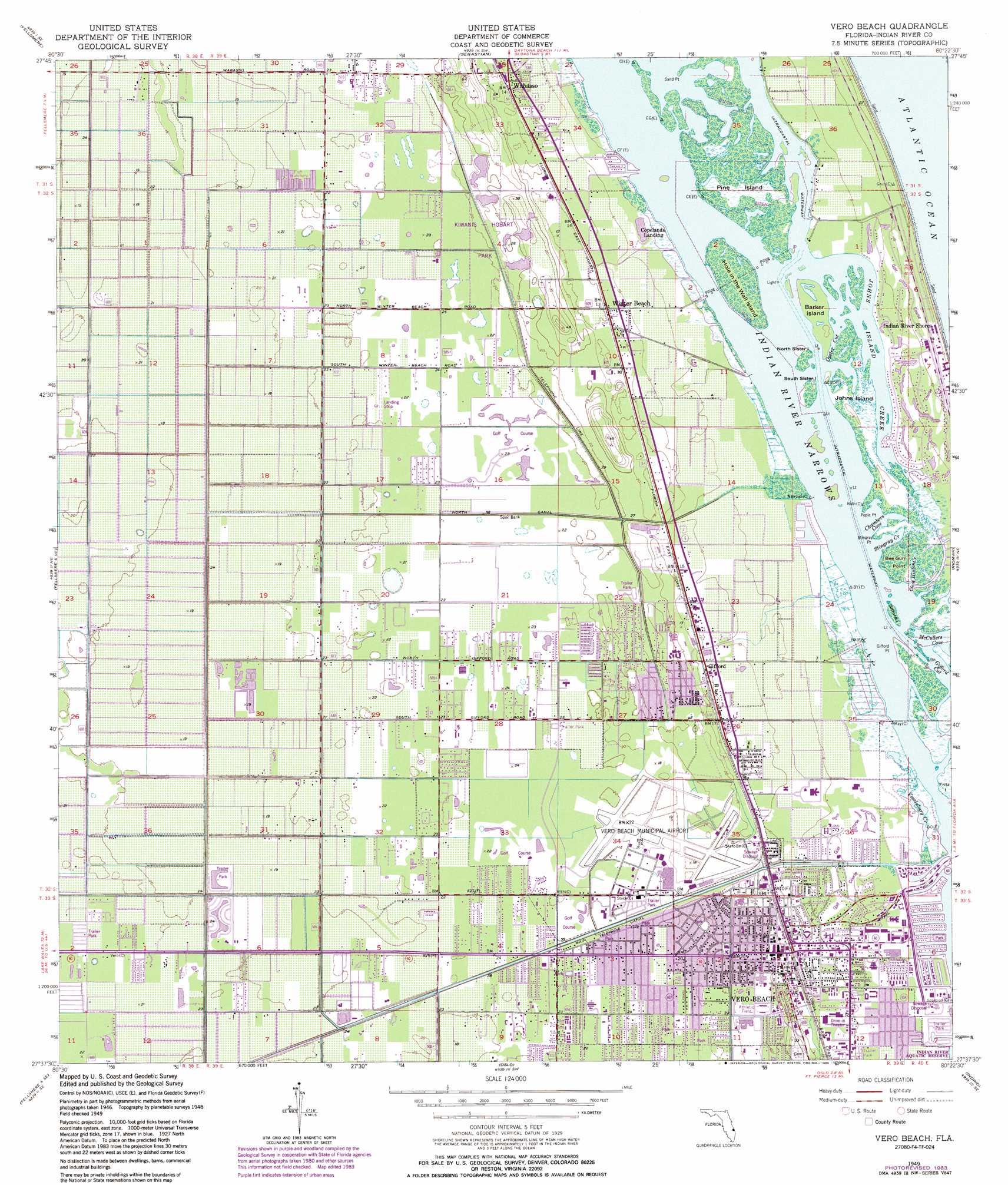
USGS Topo Quad 27080f4 - 1:24,000 scale
| Topo Map Name: | Vero Beach |
| USGS Topo Quad ID: | 27080f4 |
| Print Size: | ca. 21 1/4" wide x 27" high |
| Southeast Coordinates: | 27.625° N latitude / 80.375° W longitude |
| Map Center Coordinates: | 27.6875° N latitude / 80.4375° W longitude |
| U.S. State: | FL |
| Filename: | O27080F4.jpg |
| Download Map JPG Image: | Vero Beach topo map 1:24,000 scale |
| Map Type: | Topographic |
| Topo Series: | 7.5´ |
| Map Scale: | 1:24,000 |
| Source of Map Images: | United States Geological Survey (USGS) |
| Alternate Map Versions: |
Vero Beach FL 1949, updated 1960 Download PDF Buy paper map Vero Beach FL 1949, updated 1969 Download PDF Buy paper map Vero Beach FL 1949, updated 1971 Download PDF Buy paper map Vero Beach FL 1949, updated 1976 Download PDF Buy paper map Vero Beach FL 1949, updated 1983 Download PDF Buy paper map Vero Beach FL 1949, updated 1986 Download PDF Buy paper map Vero Beach FL 1950 Download PDF Buy paper map Vero Beach FL 2012 Download PDF Buy paper map Vero Beach FL 2015 Download PDF Buy paper map |
1:24,000 Topo Quads surrounding Vero Beach
Fellsmere Nw |
Grant |
Sebastian Nw |
||
Fellsmere Sw |
Fellsmere |
Sebastian |
||
Fellsmere 4 Nw |
Fellsmere 4 Ne |
Vero Beach |
Riomar |
|
Fellsmere 4 Sw |
Fellsmere 4 Se |
Oslo |
Indrio |
|
Okeechobee 1 Nw |
Okeechobee 1 Ne |
Fort Pierce Nw |
Fort Pierce |
> Back to 27080e1 at 1:100,000 scale
> Back to 27080a1 at 1:250,000 scale
> Back to U.S. Topo Maps home
Vero Beach topo map: Gazetteer
Vero Beach: Airports
Broocke Air Patch elevation 6m 19′Indian River Memorial Hospital Heliport elevation 2m 6′
Vero Beach Municipal Airport elevation 6m 19′
Vero Beach: Bays
Chambers Cove elevation 0m 0′Vero Beach: Canals
Main Canal elevation 6m 19′North Canal elevation 6m 19′
Vero Beach: Capes
Bee Gum Point elevation 0m 0′Gifford Point elevation 0m 0′
Pople Point elevation 0m 0′
Stingray Point elevation 0m 0′
Vero Beach: Channels
Indian River Narrows elevation 0m 0′Oyster Cut elevation 0m 0′
Vero Beach: Islands
Barker Island elevation 0m 0′Gifford Island elevation 0m 0′
Hole in the Wall Island elevation 0m 0′
Johns Island elevation 1m 3′
North Sister Island elevation 0m 0′
South Sister Island elevation 0m 0′
Vero Beach: Parks
Holman Stadium elevation 6m 19′Indian River Aquatic Reserve elevation 0m 0′
Kiwanis-Hobart Park elevation 6m 19′
Troy Moody Park elevation 6m 19′
Vero Beach: Populated Places
Connecticut Mobile Park elevation 3m 9′Country Trailer Park elevation 6m 19′
Gifford elevation 4m 13′
High Ridge Mobile Park elevation 5m 16′
Indian River Shores elevation 0m 0′
Palm Paradise Mobile Home Park elevation 3m 9′
Palm Villa Mobile Home Park elevation 4m 13′
Ranchland Mobile Home Park elevation 6m 19′
Royal Oaks Community Mobile Home Park elevation 3m 9′
Sweetwater Mobile Home Park elevation 6m 19′
Vero Beach elevation 4m 13′
Vero Mobile Home Park elevation 4m 13′
Village Green Mobile Home Park elevation 6m 19′
Wabasso elevation 4m 13′
Winter Beach elevation 3m 9′
Vero Beach: Streams
Cleve Hinton Creek elevation 0m 0′Johns Island Creek elevation 0m 0′
Stingray Creek elevation 0m 0′
Vossinbury Creek elevation 0m 0′
Vero Beach digital topo map on disk
Buy this Vero Beach topo map showing relief, roads, GPS coordinates and other geographical features, as a high-resolution digital map file on DVD: