Lake Placid Topo Map Florida
To zoom in, hover over the map of Lake Placid
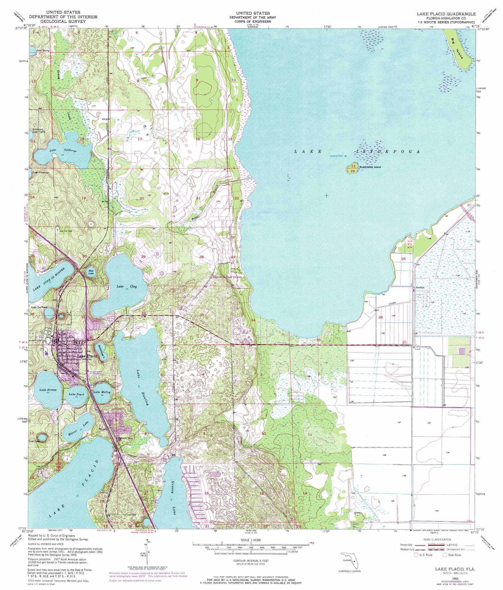
USGS Topo Quad 27081c3 - 1:24,000 scale
| Topo Map Name: | Lake Placid |
| USGS Topo Quad ID: | 27081c3 |
| Print Size: | ca. 21 1/4" wide x 27" high |
| Southeast Coordinates: | 27.25° N latitude / 81.25° W longitude |
| Map Center Coordinates: | 27.3125° N latitude / 81.3125° W longitude |
| U.S. State: | FL |
| Filename: | O27081C3.jpg |
| Download Map JPG Image: | Lake Placid topo map 1:24,000 scale |
| Map Type: | Topographic |
| Topo Series: | 7.5´ |
| Map Scale: | 1:24,000 |
| Source of Map Images: | United States Geological Survey (USGS) |
| Alternate Map Versions: |
Lake Placid FL 1952, updated 1953 Download PDF Buy paper map Lake Placid FL 1952, updated 1972 Download PDF Buy paper map Lake Placid FL 1952, updated 1973 Download PDF Buy paper map Lake Placid FL 1952, updated 1983 Download PDF Buy paper map Lake Placid FL 2012 Download PDF Buy paper map Lake Placid FL 2015 Download PDF Buy paper map |
1:24,000 Topo Quads surrounding Lake Placid
Avon Park |
Lake Arbuckle Sw |
Lake Arbuckle Se |
Fort Kissimmee |
Fort Kissimmee Se |
Crewsville |
Sebring |
Lorida |
Basinger Nw |
Basinger |
Crewsville Se |
Lake June In Winter |
Lake Placid |
Basinger Sw |
Fort Basinger |
Long Island Marsh Ne |
Venus Nw |
Childs |
Brighton Nw |
Brighton |
Long Island Marsh Se |
Venus Sw |
Venus |
Brighton Sw |
Brighton Se |
> Back to 27081a1 at 1:100,000 scale
> Back to 27080a1 at 1:250,000 scale
> Back to U.S. Topo Maps home
Lake Placid topo map: Gazetteer
Lake Placid: Airports
Florida Hospital Lake Placid Heliport elevation 35m 114′Lake Placid: Islands
Big Island elevation 13m 42′Bumblebee Island elevation 13m 42′
Lake Placid: Lakes
Blue Lake elevation 23m 75′Grassy Lake elevation 27m 88′
Lake Apthorp elevation 21m 68′
Lake Clay elevation 23m 75′
Lake Harry elevation 20m 65′
Lake Huntley elevation 25m 82′
Lake Istokpoga elevation 11m 36′
Lake LaChard elevation 21m 68′
Lake McCoy elevation 26m 85′
Lake Pearl elevation 26m 85′
Lake Sirena elevation 26m 85′
Lost Lake elevation 25m 82′
Mirror Lake elevation 28m 91′
Saddlebags Lake elevation 25m 82′
Lake Placid: Populated Places
Crawfords Trailer Park elevation 13m 42′Hickory Grove Trailer Park elevation 40m 131′
Highlands Park Estates elevation 13m 42′
Lake Gardens Mobile Home Park elevation 26m 85′
Lake Placid elevation 46m 150′
Lakeside Village Mobile Home Park elevation 28m 91′
Paradise Mobile Village elevation 32m 104′
Sunvale elevation 12m 39′
Sylvan Shores elevation 25m 82′
Tropical Harbor Estates Mobile Home Park elevation 24m 78′
Lake Placid: Post Offices
Lake Placid Post Office elevation 48m 157′Lake Placid: Streams
Boggy Branch elevation 11m 36′Lake Placid digital topo map on disk
Buy this Lake Placid topo map showing relief, roads, GPS coordinates and other geographical features, as a high-resolution digital map file on DVD: