Sebring Topo Map Florida
To zoom in, hover over the map of Sebring
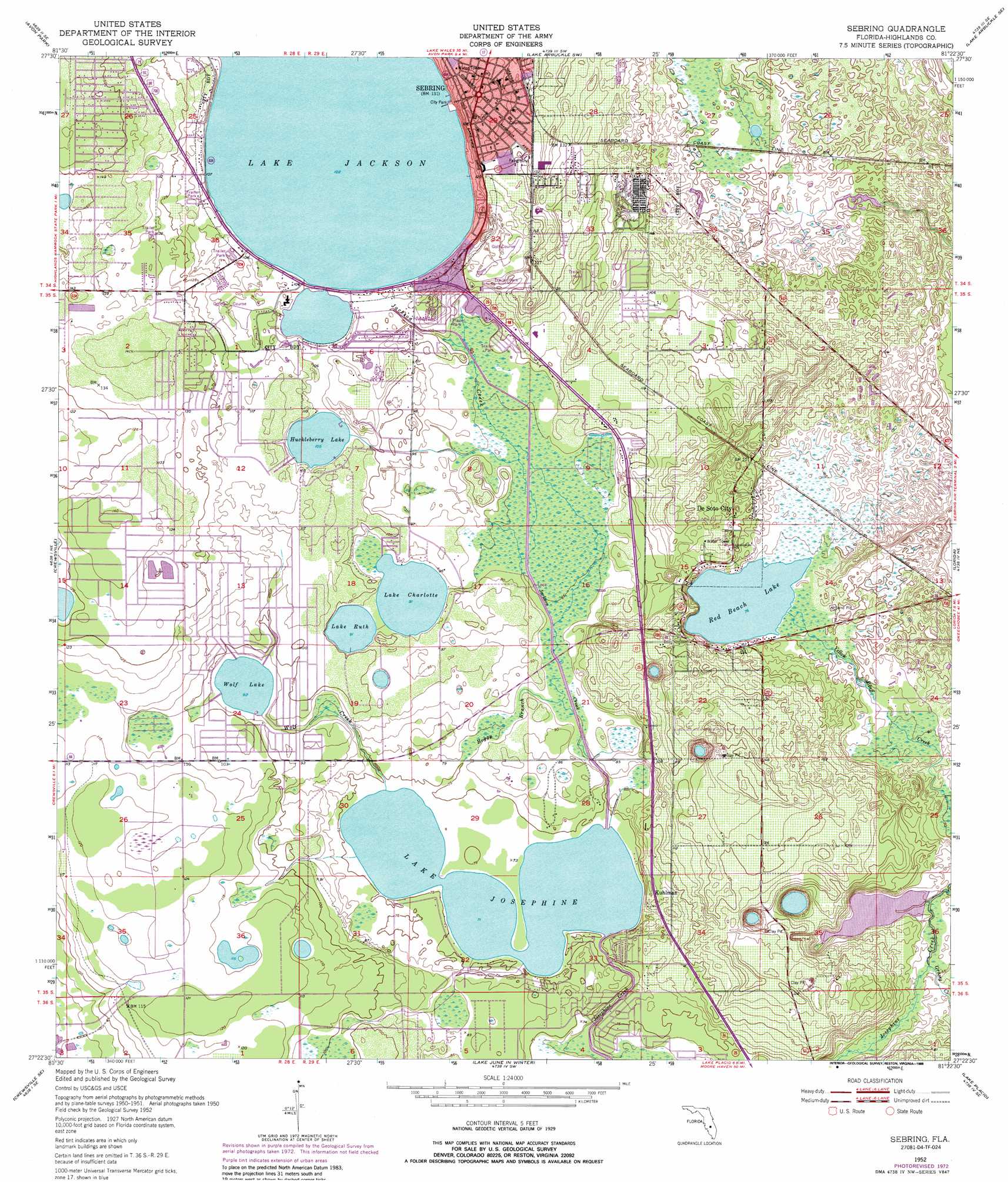
USGS Topo Quad 27081d4 - 1:24,000 scale
| Topo Map Name: | Sebring |
| USGS Topo Quad ID: | 27081d4 |
| Print Size: | ca. 21 1/4" wide x 27" high |
| Southeast Coordinates: | 27.375° N latitude / 81.375° W longitude |
| Map Center Coordinates: | 27.4375° N latitude / 81.4375° W longitude |
| U.S. State: | FL |
| Filename: | O27081D4.jpg |
| Download Map JPG Image: | Sebring topo map 1:24,000 scale |
| Map Type: | Topographic |
| Topo Series: | 7.5´ |
| Map Scale: | 1:24,000 |
| Source of Map Images: | United States Geological Survey (USGS) |
| Alternate Map Versions: |
Sebring FL 1952, updated 1953 Download PDF Buy paper map Sebring FL 1952, updated 1965 Download PDF Buy paper map Sebring FL 1952, updated 1973 Download PDF Buy paper map Sebring FL 1952, updated 1988 Download PDF Buy paper map Sebring FL 2012 Download PDF Buy paper map Sebring FL 2015 Download PDF Buy paper map |
1:24,000 Topo Quads surrounding Sebring
Bereah |
Frostproof |
Lake Arbuckle |
Lake Arbuckle Ne |
Fort Kissimmee Nw |
Griffins Corner |
Avon Park |
Lake Arbuckle Sw |
Lake Arbuckle Se |
Fort Kissimmee |
Sweetwater |
Crewsville |
Sebring |
Lorida |
Basinger Nw |
Crewsville Sw |
Crewsville Se |
Lake June In Winter |
Lake Placid |
Basinger Sw |
Long Island Marsh Nw |
Long Island Marsh Ne |
Venus Nw |
Childs |
Brighton Nw |
> Back to 27081a1 at 1:100,000 scale
> Back to 27080a1 at 1:250,000 scale
> Back to U.S. Topo Maps home
Sebring topo map: Gazetteer
Sebring: Airports
Highlands Regional Medical Center Heliport elevation 33m 108′Sebring: Canals
Jackson Creek elevation 26m 85′Sebring: Guts
Boggy Branch elevation 25m 82′Sebring: Lakes
Frank Taucher Reservoir elevation 16m 52′Huckleberry Lake elevation 32m 104′
Lake Charlotte elevation 27m 88′
Lake Josephine elevation 21m 68′
Lake Ruth elevation 27m 88′
Red Beach Lake elevation 23m 75′
Wolf Lake elevation 28m 91′
Sebring: Populated Places
Braswells Heritage Estates Mobile Home Park elevation 37m 121′Buttonwood Bay Mobile Home Park elevation 24m 78′
De Soto City elevation 30m 98′
Desoto Mobile Home Park elevation 37m 121′
Francis I Mobile Estates elevation 33m 108′
Hammock Mobile Estates Mobile Home Park elevation 40m 131′
Highland Wheel Estates Mobile Home Park elevation 33m 108′
Jackson Creek Mobile Estates elevation 31m 101′
Josephine Lakeside Park Mobile Home Park elevation 28m 91′
Kuhlman elevation 28m 91′
Lakeshore Mobile Home Park elevation 35m 114′
Leisure Acres Mobile Home Park elevation 29m 95′
Oak Gardens Mobile Home Park elevation 29m 95′
Oak Ridge Mobile Home Park elevation 35m 114′
Oakridge Mobile Home Park elevation 35m 114′
Sebring elevation 41m 134′
Sebring Gardens Trailer Park elevation 38m 124′
Sebring Mobile Estates elevation 39m 127′
Sunshine Park Mobile Home Park elevation 41m 134′
The Highlander Mobile Home Court elevation 28m 91′
Town and Country Mobile Home Park elevation 29m 95′
Valencia Family Mobile Home Park elevation 37m 121′
Whispering Pines Village Mobile Home Park elevation 41m 134′
Woodhaven Estates Mobile Home Park elevation 39m 127′
Sebring: Streams
Grassy Creek elevation 15m 49′Wolf Creek elevation 22m 72′
Sebring digital topo map on disk
Buy this Sebring topo map showing relief, roads, GPS coordinates and other geographical features, as a high-resolution digital map file on DVD: