Lake Arbuckle Sw Topo Map Florida
To zoom in, hover over the map of Lake Arbuckle Sw
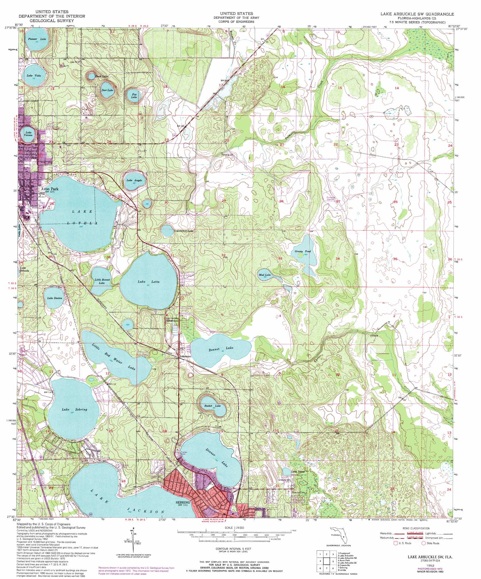
USGS Topo Quad 27081e4 - 1:24,000 scale
| Topo Map Name: | Lake Arbuckle Sw |
| USGS Topo Quad ID: | 27081e4 |
| Print Size: | ca. 21 1/4" wide x 27" high |
| Southeast Coordinates: | 27.5° N latitude / 81.375° W longitude |
| Map Center Coordinates: | 27.5625° N latitude / 81.4375° W longitude |
| U.S. State: | FL |
| Filename: | O27081E4.jpg |
| Download Map JPG Image: | Lake Arbuckle Sw topo map 1:24,000 scale |
| Map Type: | Topographic |
| Topo Series: | 7.5´ |
| Map Scale: | 1:24,000 |
| Source of Map Images: | United States Geological Survey (USGS) |
| Alternate Map Versions: |
Lake Arbuckle SW FL 1952, updated 1953 Download PDF Buy paper map Lake Arbuckle SW FL 1952, updated 1965 Download PDF Buy paper map Lake Arbuckle SW FL 1952, updated 1973 Download PDF Buy paper map Lake Arbuckle SW FL 1952, updated 1993 Download PDF Buy paper map Lake Arbuckle SW FL 2012 Download PDF Buy paper map Lake Arbuckle SW FL 2015 Download PDF Buy paper map |
1:24,000 Topo Quads surrounding Lake Arbuckle Sw
Alturas |
Babson Park |
Lake Weohyakapka |
Lake Weohyakpka Se |
Lake Marian Sw |
Bereah |
Frostproof |
Lake Arbuckle |
Lake Arbuckle Ne |
Fort Kissimmee Nw |
Griffins Corner |
Avon Park |
Lake Arbuckle Sw |
Lake Arbuckle Se |
Fort Kissimmee |
Sweetwater |
Crewsville |
Sebring |
Lorida |
Basinger Nw |
Crewsville Sw |
Crewsville Se |
Lake June In Winter |
Lake Placid |
Basinger Sw |
> Back to 27081e1 at 1:100,000 scale
> Back to 27080a1 at 1:250,000 scale
> Back to U.S. Topo Maps home
Lake Arbuckle Sw topo map: Gazetteer
Lake Arbuckle Sw: Lakes
Basket Lake elevation 30m 98′Bonnet Lake elevation 27m 88′
Counterfeit Lake elevation 30m 98′
Deer Lake elevation 28m 91′
Dinner Lake elevation 30m 98′
Duck Lake elevation 29m 95′
Fox Lake elevation 31m 101′
Grassy Pond elevation 31m 101′
Lake Angelo elevation 28m 91′
Lake Denton elevation 34m 111′
Lake Jackson elevation 31m 101′
Lake Letta elevation 29m 95′
Lake Lotela elevation 32m 104′
Lake Lucas elevation 30m 98′
Lake Sebring elevation 32m 104′
Lake Verona elevation 32m 104′
Lake Viola elevation 34m 111′
Little Bonnet Lake elevation 29m 95′
Little Red Water Lake elevation 31m 101′
Mud Lake elevation 30m 98′
Pioneer Lake elevation 30m 98′
Lake Arbuckle Sw: Populated Places
Dinner Lake Haven Mobile Home elevation 37m 121′Hagners Trailer Park elevation 38m 124′
Lake Bonnet Village Mobile Home Park elevation 29m 95′
Lake Letta Mobile Home Court elevation 33m 108′
Lake Viola Trailer Park elevation 35m 114′
Lakemont elevation 30m 98′
Marina Cove Mobile Home Park elevation 30m 98′
Sebring Resort Mobile Home Park elevation 36m 118′
Sebring Shores elevation 35m 114′
Sweeneys Mobile Home Park elevation 38m 124′
Washburn Mobile Home Park elevation 39m 127′
Lake Arbuckle Sw: Post Offices
Sebring Post Offce elevation 40m 131′Lake Arbuckle Sw: Streams
Bonnet Creek elevation 16m 52′Palmetto Creek elevation 16m 52′
Lake Arbuckle Sw digital topo map on disk
Buy this Lake Arbuckle Sw topo map showing relief, roads, GPS coordinates and other geographical features, as a high-resolution digital map file on DVD: