Bradley Junction Topo Map Florida
To zoom in, hover over the map of Bradley Junction
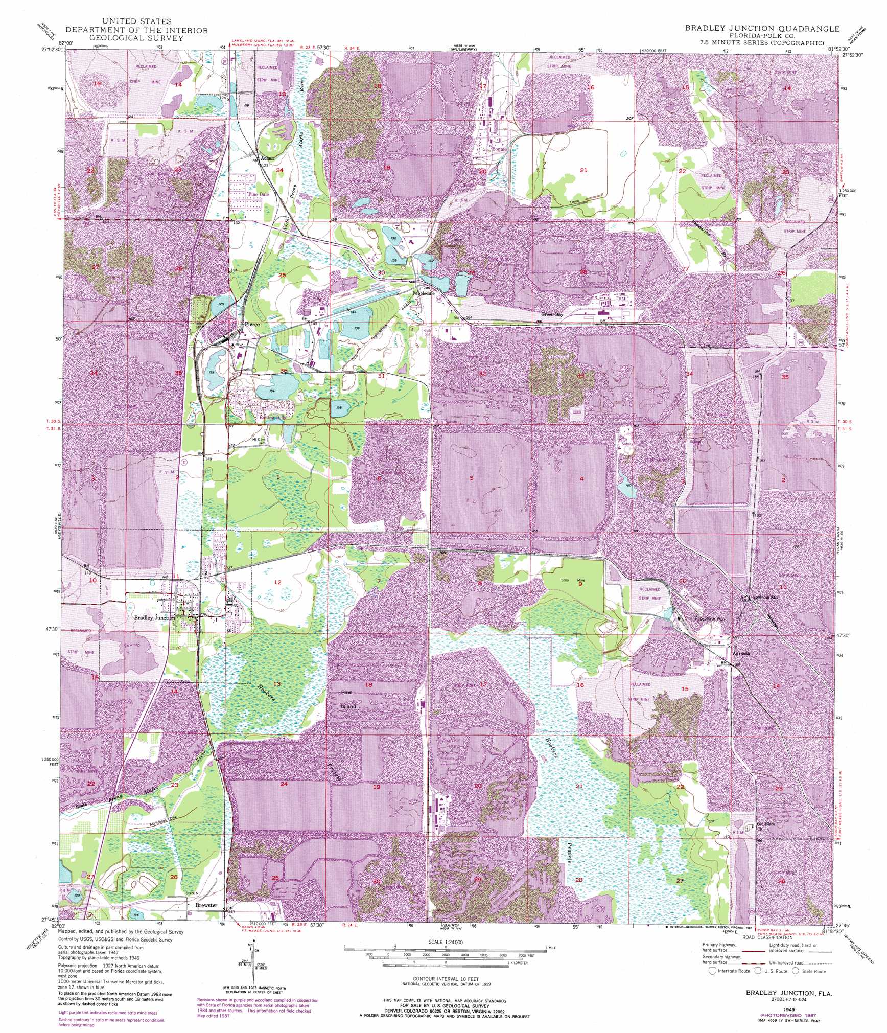
USGS Topo Quad 27081g8 - 1:24,000 scale
| Topo Map Name: | Bradley Junction |
| USGS Topo Quad ID: | 27081g8 |
| Print Size: | ca. 21 1/4" wide x 27" high |
| Southeast Coordinates: | 27.75° N latitude / 81.875° W longitude |
| Map Center Coordinates: | 27.8125° N latitude / 81.9375° W longitude |
| U.S. State: | FL |
| Filename: | O27081G8.jpg |
| Download Map JPG Image: | Bradley Junction topo map 1:24,000 scale |
| Map Type: | Topographic |
| Topo Series: | 7.5´ |
| Map Scale: | 1:24,000 |
| Source of Map Images: | United States Geological Survey (USGS) |
| Alternate Map Versions: |
Bradley Junction FL 1949, updated 1966 Download PDF Buy paper map Bradley Junction FL 1949, updated 1973 Download PDF Buy paper map Bradley Junction FL 1949, updated 1987 Download PDF Buy paper map Bradley Junction FL 1950 Download PDF Buy paper map Bradley Junction FL 2012 Download PDF Buy paper map Bradley Junction FL 2015 Download PDF Buy paper map |
1:24,000 Topo Quads surrounding Bradley Junction
Plant City West |
Plant City East |
Lakeland |
Auburndale |
Winter Haven |
Dover |
Nichols |
Mulberry |
Bartow |
Eloise |
Lithia |
Keysville |
Bradley Junction |
Homeland |
Alturas |
Fort Lonesome |
Duette Ne |
Baird |
Bowling Green |
Bereah |
Keentown |
Duette |
Fort Green |
Wauchula |
Griffins Corner |
> Back to 27081e1 at 1:100,000 scale
> Back to 27080a1 at 1:250,000 scale
> Back to U.S. Topo Maps home
Bradley Junction topo map: Gazetteer
Bradley Junction: Islands
Pine Island elevation 37m 121′Bradley Junction: Mines
Bonnie Mine elevation 53m 173′Bradley Junction: Populated Places
Achan elevation 37m 121′Agricola elevation 52m 170′
Barcola elevation 44m 144′
Bonnie elevation 55m 180′
Bradley Junction elevation 41m 134′
Brewster elevation 42m 137′
Green Bay elevation 49m 160′
Oak Terrace elevation 49m 160′
Pebbledale elevation 43m 141′
Pierce elevation 41m 134′
Pine Dale elevation 38m 124′
Rolling Hills elevation 48m 157′
Bradley Junction: Streams
Cedar Branch elevation 40m 131′Sweetwater Branch elevation 42m 137′
Bradley Junction: Swamps
Hookers Prairie elevation 39m 127′Mill Bay (historical) elevation 38m 124′
Sixmile Creek elevation 41m 134′
Bradley Junction digital topo map on disk
Buy this Bradley Junction topo map showing relief, roads, GPS coordinates and other geographical features, as a high-resolution digital map file on DVD: