Eloise Topo Map Florida
To zoom in, hover over the map of Eloise
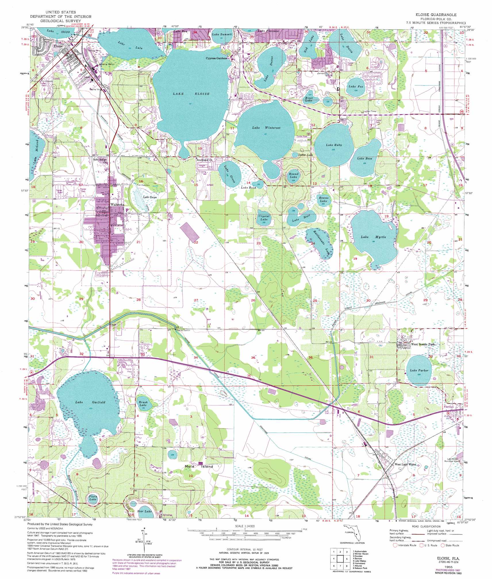
USGS Topo Quad 27081h6 - 1:24,000 scale
| Topo Map Name: | Eloise |
| USGS Topo Quad ID: | 27081h6 |
| Print Size: | ca. 21 1/4" wide x 27" high |
| Southeast Coordinates: | 27.875° N latitude / 81.625° W longitude |
| Map Center Coordinates: | 27.9375° N latitude / 81.6875° W longitude |
| U.S. State: | FL |
| Filename: | O27081H6.jpg |
| Download Map JPG Image: | Eloise topo map 1:24,000 scale |
| Map Type: | Topographic |
| Topo Series: | 7.5´ |
| Map Scale: | 1:24,000 |
| Source of Map Images: | United States Geological Survey (USGS) |
| Alternate Map Versions: |
Eloise FL 1955, updated 1956 Download PDF Buy paper map Eloise FL 1955, updated 1973 Download PDF Buy paper map Eloise FL 1955, updated 1987 Download PDF Buy paper map Eloise FL 1955, updated 1993 Download PDF Buy paper map Eloise FL 1955, updated 1993 Download PDF Buy paper map Eloise FL 2012 Download PDF Buy paper map Eloise FL 2015 Download PDF Buy paper map |
1:24,000 Topo Quads surrounding Eloise
Providence |
Polk City |
Gum Lake |
Davenport |
Lake Tohopekaliga |
Lakeland |
Auburndale |
Winter Haven |
Dundee |
Lake Hatchineha |
Mulberry |
Bartow |
Eloise |
Lake Wales |
Hesperides |
Bradley Junction |
Homeland |
Alturas |
Babson Park |
Lake Weohyakapka |
Baird |
Bowling Green |
Bereah |
Frostproof |
Lake Arbuckle |
> Back to 27081e1 at 1:100,000 scale
> Back to 27080a1 at 1:250,000 scale
> Back to U.S. Topo Maps home
Eloise topo map: Gazetteer
Eloise: Canals
Peace Creek Drainage Canal elevation 33m 108′Wahneta Farms Drainage Canal elevation 39m 127′
Eloise: Islands
Mule Island elevation 38m 124′Eloise: Lakes
Brush Lake elevation 36m 118′Crystal Lake elevation 39m 127′
Dollar Lake elevation 41m 134′
Flora Lake elevation 35m 114′
Lake Ashton elevation 36m 118′
Lake Bess elevation 38m 124′
Lake Daisy elevation 40m 131′
Lake Dexter elevation 41m 134′
Lake Eloise elevation 40m 131′
Lake Fox elevation 41m 134′
Lake Garfield elevation 30m 98′
Lake Gross elevation 41m 134′
Lake Gwyn elevation 38m 124′
Lake Hart elevation 38m 124′
Lake Lulu elevation 40m 131′
Lake Parker elevation 37m 121′
Lake Reed elevation 40m 131′
Lake Ruby elevation 38m 124′
Lake Summit elevation 40m 131′
Lake Winterset elevation 40m 131′
Ned Lake elevation 40m 131′
Rattlesnake Lake elevation 36m 118′
Reeves Lake elevation 38m 124′
River Lake elevation 41m 134′
Round Lake elevation 39m 127′
Star Lake elevation 35m 114′
Eloise: Parks
Cypress Gardens elevation 44m 144′Eloise: Populated Places
Big Oak Mobile Home Park elevation 41m 134′Cypress Gardens elevation 51m 167′
Cypress Harbor Mobile Home Park elevation 42m 137′
Dexter Shores Mobile Park elevation 41m 134′
Eloise elevation 41m 134′
Garden Mobile Village elevation 40m 131′
Grove Park Lane Mobile Home Park elevation 43m 141′
Grove Shores Mobile Colony elevation 43m 141′
Hammondell Mobile Home Park elevation 46m 150′
Lake Fox Village Mobile Home Park elevation 43m 141′
Lake Shipp Heights elevation 43m 141′
Lakeshore Palms Travel Park elevation 42m 137′
Lowes Mobile Home Park elevation 41m 134′
Manley Mobile Home Park elevation 38m 124′
Orange Manor Mobile Home Park East elevation 42m 137′
Orange Manor Mobile Home Park West elevation 42m 137′
Rainbow Trailer Park elevation 41m 134′
Rifle Range Mobile Home elevation 41m 134′
Rosemont Mobile Home Park elevation 40m 131′
Santa Fe Mobile Home Park elevation 42m 137′
Wahneta elevation 40m 131′
West Lake Wales elevation 37m 121′
West Scenic Park elevation 40m 131′
Winterset Shores Estates Mobile Home Park elevation 44m 144′
Eloise: Post Offices
Eloise Post Office elevation 41m 134′Wahneta Post Office (historical) elevation 40m 131′
Eloise: Streams
Boggy Branch elevation 30m 98′Eloise digital topo map on disk
Buy this Eloise topo map showing relief, roads, GPS coordinates and other geographical features, as a high-resolution digital map file on DVD: