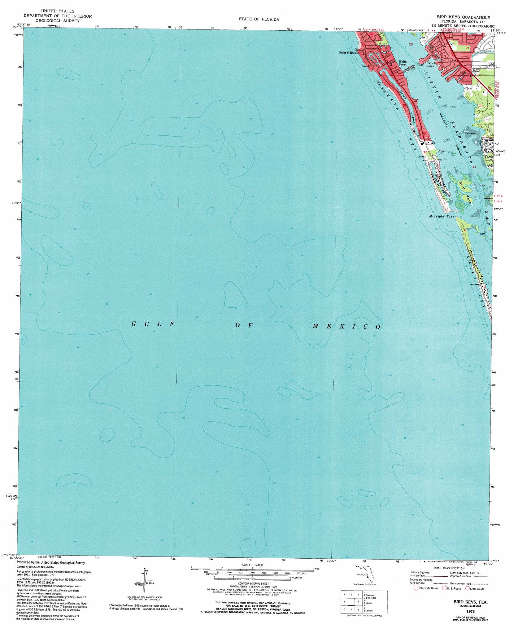
Bird Keys Topo Map Florida
To zoom in, hover over the map of Bird Keys
USGS Topo Quad 27082b5 - 1:24,000 scale
| Topo Map Name: | Bird Keys |
| USGS Topo Quad ID: | 27082b5 |
| Print Size: | ca. 21 1/4" wide x 27" high |
| Southeast Coordinates: | 27.125° N latitude / 82.5° W longitude |
| Map Center Coordinates: | 27.1875° N latitude / 82.5625° W longitude |
| U.S. State: | FL |
| Filename: | O27082B5.jpg |
| Download Map JPG Image: | Bird Keys topo map 1:24,000 scale |
| Map Type: | Topographic |
| Topo Series: | 7.5´ |
| Map Scale: | 1:24,000 |
| Source of Map Images: | United States Geological Survey (USGS) |
| Alternate Map Versions: |
Bird Keys FL 1944, updated 1961 Download PDF Buy paper map Bird Keys FL 1973, updated 1974 Download PDF Buy paper map Bird Keys FL 1973, updated 1992 Download PDF Buy paper map Bird Keys FL 2012 Download PDF Buy paper map Bird Keys FL 2015 Download PDF Buy paper map |
1:24,000 Topo Quads surrounding Bird Keys
Bradenton Beach |
Bradenton |
Lorraine |
Verna |
|
Sarasota |
Bee Ridge |
Old Myakka |
||
Bird Keys |
Laurel |
Lower Myakka Lake |
||
Venice |
Myakka River |
|||
Englewood Nw |
Englewood |
> Back to 27082a1 at 1:100,000 scale
> Back to 27082a1 at 1:250,000 scale
> Back to U.S. Topo Maps home
Bird Keys topo map: Gazetteer
Bird Keys: Bays
Coral Cove elevation 0m 0′Little Sarasota Bay elevation 0m 0′
Bird Keys: Channels
Midnight Pass elevation 0m 0′Bird Keys: Guts
Blind Pass elevation 0m 0′Bird Keys: Islands
Bird Keys elevation 0m 0′Bird Keys: Lakes
Heron Lagoon elevation 0m 0′Bird Keys: Parks
Jim Neville Marine Preserve elevation 0m 0′Bird Keys: Populated Places
Point O'Rocks elevation 2m 6′White Beach elevation 1m 3′
Bird Keys: Streams
Catfish Creek elevation 0m 0′Bird Keys digital topo map on disk
Buy this Bird Keys topo map showing relief, roads, GPS coordinates and other geographical features, as a high-resolution digital map file on DVD: