Parrish Topo Map Florida
To zoom in, hover over the map of Parrish
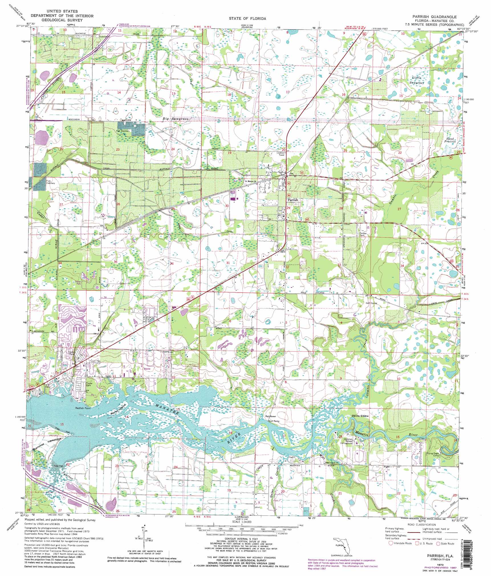
USGS Topo Quad 27082e4 - 1:24,000 scale
| Topo Map Name: | Parrish |
| USGS Topo Quad ID: | 27082e4 |
| Print Size: | ca. 21 1/4" wide x 27" high |
| Southeast Coordinates: | 27.5° N latitude / 82.375° W longitude |
| Map Center Coordinates: | 27.5625° N latitude / 82.4375° W longitude |
| U.S. State: | FL |
| Filename: | O27082E4.jpg |
| Download Map JPG Image: | Parrish topo map 1:24,000 scale |
| Map Type: | Topographic |
| Topo Series: | 7.5´ |
| Map Scale: | 1:24,000 |
| Source of Map Images: | United States Geological Survey (USGS) |
| Alternate Map Versions: |
Parrish FL 1944, updated 1961 Download PDF Buy paper map Parrish FL 1973, updated 1974 Download PDF Buy paper map Parrish FL 1973, updated 1987 Download PDF Buy paper map Parrish FL 1973, updated 1987 Download PDF Buy paper map Parrish FL 2012 Download PDF Buy paper map Parrish FL 2015 Download PDF Buy paper map |
1:24,000 Topo Quads surrounding Parrish
Saint Petersburg |
Port Tampa |
Gibsonton |
Riverview |
Lithia |
Pass-A-Grille Beach |
Cockroach Bay |
Ruskin |
Wimauma |
Fort Lonesome |
Anna Maria |
Palmetto |
Parrish |
Rye |
Keentown |
Bradenton Beach |
Bradenton |
Lorraine |
Verna |
Myakka City Nw |
Sarasota |
Bee Ridge |
Old Myakka |
Myakka City |
> Back to 27082e1 at 1:100,000 scale
> Back to 27082a1 at 1:250,000 scale
> Back to U.S. Topo Maps home
Parrish topo map: Gazetteer
Parrish: Bends
Devils Elbow elevation 2m 6′Parrish: Canals
Buffalo Canal elevation 6m 19′Wade Canal elevation 9m 29′
Parrish: Capes
Redfish Point elevation 1m 3′Parrish: Islands
Branches Hammock elevation 1m 3′Marsh Island elevation 0m 0′
Parrish: Populated Places
Erie elevation 10m 32′Fort Hamer elevation 2m 6′
Parrish elevation 12m 39′
Parrish: Streams
Cypress Strand elevation 0m 0′Gamble Creek elevation 0m 0′
Gates Creek elevation 0m 0′
Goddard Creek elevation 0m 0′
Mill Creek elevation 0m 0′
Parrish: Swamps
Big Sawgrass elevation 9m 29′Little Sawgrass elevation 7m 22′
Sand Prairie elevation 6m 19′
Parrish digital topo map on disk
Buy this Parrish topo map showing relief, roads, GPS coordinates and other geographical features, as a high-resolution digital map file on DVD: