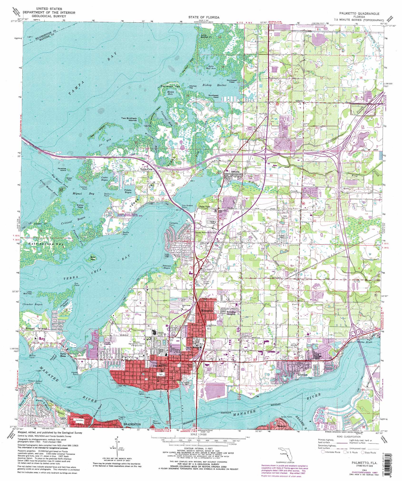
Palmetto Topo Map Florida
To zoom in, hover over the map of Palmetto
USGS Topo Quad 27082e5 - 1:24,000 scale
| Topo Map Name: | Palmetto |
| USGS Topo Quad ID: | 27082e5 |
| Print Size: | ca. 21 1/4" wide x 27" high |
| Southeast Coordinates: | 27.5° N latitude / 82.5° W longitude |
| Map Center Coordinates: | 27.5625° N latitude / 82.5625° W longitude |
| U.S. State: | FL |
| Filename: | O27082E5.jpg |
| Download Map JPG Image: | Palmetto topo map 1:24,000 scale |
| Map Type: | Topographic |
| Topo Series: | 7.5´ |
| Map Scale: | 1:24,000 |
| Source of Map Images: | United States Geological Survey (USGS) |
| Alternate Map Versions: |
Ellenton FL 1944, updated 1961 Download PDF Buy paper map Palmetto FL 1964, updated 1965 Download PDF Buy paper map Palmetto FL 1964, updated 1970 Download PDF Buy paper map Palmetto FL 1964, updated 1982 Download PDF Buy paper map Palmetto FL 1964, updated 1987 Download PDF Buy paper map Palmetto FL 2012 Download PDF Buy paper map Palmetto FL 2015 Download PDF Buy paper map |
1:24,000 Topo Quads surrounding Palmetto
Seminole |
Saint Petersburg |
Port Tampa |
Gibsonton |
Riverview |
Pass-A-Grille Beach |
Cockroach Bay |
Ruskin |
Wimauma |
|
Egmont Key |
Anna Maria |
Palmetto |
Parrish |
Rye |
Bradenton Beach |
Bradenton |
Lorraine |
Verna |
|
Sarasota |
Bee Ridge |
Old Myakka |
> Back to 27082e1 at 1:100,000 scale
> Back to 27082a1 at 1:250,000 scale
> Back to U.S. Topo Maps home
Palmetto topo map: Gazetteer
Palmetto: Airports
Ellenton Airport elevation 10m 32′Palmetto: Bays
Bishop Harbor elevation 0m 0′Champlain Bayou elevation 0m 0′
Clambar Bay elevation 0m 0′
Clambar Bayou elevation 0m 0′
Critical Bayou elevation 0m 0′
Custer Bayou elevation 0m 0′
Hells Half Acre elevation 0m 0′
Joe Bay elevation 0m 0′
Miguel Bay elevation 0m 0′
Peterson Bayou elevation 0m 0′
Terra Ceia Bay elevation 0m 0′
Tillette Bayou elevation 0m 0′
Williams Bayou elevation 0m 0′
Palmetto: Bridges
Green Bridge elevation 0m 0′Palmetto: Capes
Ayres Point elevation 0m 0′Beville Point elevation 0m 0′
Boots Point elevation 0m 0′
Fletcher Point elevation 0m 0′
Fogarty Point elevation 0m 0′
Gus Point elevation 0m 0′
Hooker Point elevation 0m 0′
McKay Point elevation 0m 0′
McNeil Point elevation 0m 0′
Northeast Head elevation 0m 0′
Palmetto Point elevation 1m 3′
Point Ogden elevation 1m 3′
Point Pleasant elevation 0m 0′
Sea Breeze Point elevation -1m -4′
Southeast Head elevation 0m 0′
Palmetto: Channels
Big Miguel Pass elevation 0m 0′Flounder Pass elevation 0m 0′
Little Miguel Pass elevation 0m 0′
Snead Island Cutoff elevation 0m 0′
Palmetto: Cliffs
Rocky Bluff elevation 0m 0′Palmetto: Guts
Little Redfish elevation 0m 0′Terra Ceia River elevation 1m 3′
Warner East Bayou elevation 0m 0′
Warner West Bayou elevation 0m 0′
Palmetto: Islands
Bird Key elevation 1m 3′Eds Key elevation 1m 3′
Harbor Key elevation 0m 0′
Horseshoe Key elevation 1m 3′
Joe Island elevation 0m 0′
Kitchen Key elevation 0m 0′
Little Bird Key elevation 0m 0′
Mariposa Key elevation 1m 3′
Paradise Island elevation 0m 0′
Rattlesnake Key elevation 1m 3′
Sister Keys elevation 1m 3′
Skeet Key elevation 0m 0′
Snead Island elevation 1m 3′
Terra Ceia Island elevation 1m 3′
Two Brothers Islands elevation 0m 0′
Palmetto: Lakes
Moses Hole elevation 0m 0′Palmetto: Parks
Judah P Benjamin Confederate Memorial at Gamble Plantation Historic State Park elevation 3m 9′Palmetto: Populated Places
Ellenton elevation 3m 9′Fullers Earth elevation 1m 3′
Gillette elevation 11m 36′
Manavista elevation 1m 3′
Memphis elevation 6m 19′
Memphis Heights elevation 5m 16′
Palm View elevation 4m 13′
Palmetto elevation 3m 9′
Rubonia elevation 1m 3′
Terra Ceia elevation 1m 3′
Terra Mana elevation 1m 3′
West Bradenton elevation 5m 16′
Palmetto: Streams
Braden River elevation 2m 6′Cabbage Slough elevation 2m 6′
Cedar Drain elevation 2m 6′
Critical Creek elevation 0m 0′
Frog Creek elevation 0m 0′
McMullen Creek elevation 0m 0′
Wares Creek elevation 0m 0′
Palmetto digital topo map on disk
Buy this Palmetto topo map showing relief, roads, GPS coordinates and other geographical features, as a high-resolution digital map file on DVD: