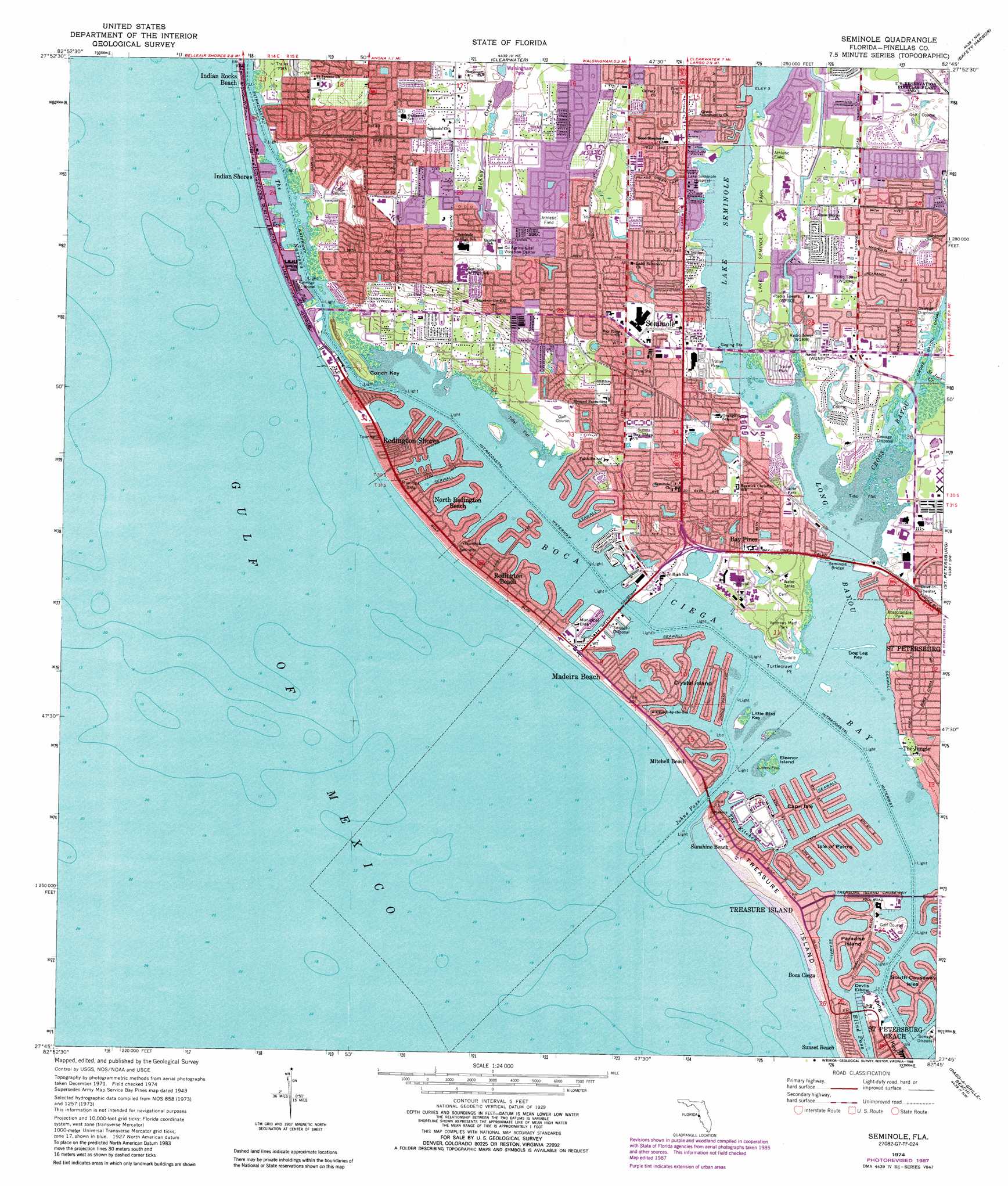
Seminole Topo Map Florida
To zoom in, hover over the map of Seminole
USGS Topo Quad 27082g7 - 1:24,000 scale
| Topo Map Name: | Seminole |
| USGS Topo Quad ID: | 27082g7 |
| Print Size: | ca. 21 1/4" wide x 27" high |
| Southeast Coordinates: | 27.75° N latitude / 82.75° W longitude |
| Map Center Coordinates: | 27.8125° N latitude / 82.8125° W longitude |
| U.S. State: | FL |
| Filename: | O27082G7.jpg |
| Download Map JPG Image: | Seminole topo map 1:24,000 scale |
| Map Type: | Topographic |
| Topo Series: | 7.5´ |
| Map Scale: | 1:24,000 |
| Source of Map Images: | United States Geological Survey (USGS) |
| Alternate Map Versions: |
Bay Pines FL 1943, updated 1961 Download PDF Buy paper map Bay Pines FL 1943, updated 1961 Download PDF Buy paper map Seminole FL 1974, updated 1976 Download PDF Buy paper map Seminole FL 1974, updated 1988 Download PDF Buy paper map Seminole FL 1995, updated 1999 Download PDF Buy paper map Seminole FL 2012 Download PDF Buy paper map Seminole FL 2015 Download PDF Buy paper map |
1:24,000 Topo Quads surrounding Seminole
Dunedin |
Oldsmar |
Citrus Park |
||
Clearwater |
Safety Harbor |
Gandy Bridge |
||
Seminole |
Saint Petersburg |
Port Tampa |
||
Pass-A-Grille Beach |
Cockroach Bay |
|||
Egmont Key |
Anna Maria |
Palmetto |
> Back to 27082e1 at 1:100,000 scale
> Back to 27082a1 at 1:250,000 scale
> Back to U.S. Topo Maps home
Seminole topo map: Gazetteer
Seminole: Airports
Bay Pines Veterans Administration Heliport elevation 3m 9′Seminole: Basins
Jacks Boat Basin elevation 0m 0′Seminole: Bays
Boca Ciega Bay elevation 0m 0′Cross Bayou elevation 0m 0′
Long Bayou elevation 0m 0′
Seminole: Bridges
Seminole Bridge elevation 0m 0′Treasure Island Causeway elevation 0m 0′
Seminole: Capes
Crystal Island elevation 0m 0′Punkin Key elevation 1m 3′
Tripod Key elevation 0m 0′
Turtlecrawl Point elevation 0m 0′
Seminole: Channels
Blind Pass elevation 0m 0′Devils Elbow elevation 0m 0′
Johns Pass elevation 0m 0′
The Kitchen elevation 0m 0′
The Narrows elevation 0m 0′
Seminole: Islands
Capri Isle elevation 1m 3′Conch Key elevation 2m 6′
Dog Leg Key elevation 0m 0′
Eleanor Island elevation 0m 0′
Isle of Palms elevation 0m 0′
Little Bird Key elevation 0m 0′
Paradise Island elevation 0m 0′
Treasure Island elevation 1m 3′
Seminole: Lakes
Blossom Lake elevation 9m 29′Lake Carol elevation 10m 32′
Lake Kersky elevation 5m 16′
Lake Seminole elevation 1m 3′
Seminole: Parks
Abercrombie Park elevation 3m 9′Blossom Lake Park elevation 16m 52′
Causeway Park elevation 0m 0′
Constitution Park elevation 1m 3′
Del Bello Park elevation 0m 0′
Downtown Community Center and Park elevation 1m 3′
Egan Park elevation 1m 3′
Friendship Park elevation 0m 0′
Holland G Mangum Recreation Complex elevation 10m 32′
Jungle Prada and DeNavarez Park elevation 2m 6′
Kingfish Park elevation 0m 0′
Lake Seminole Park elevation 2m 6′
McKenney Park elevation 2m 6′
McLaughlin Park elevation 1m 3′
Medeira Beach Access elevation 1m 3′
Moon Park elevation 1m 3′
Pinellas County State Aquatic Preserve elevation 0m 0′
Redington Shores Beach Access elevation 1m 3′
Rosselli Park elevation 2m 6′
Seminole City Park elevation 16m 52′
Seminole Tennis Club Park elevation 11m 36′
Sunset Vista Park elevation 2m 6′
Thelma Spitzer Park elevation 1m 3′
Tom and Kitty Stuart Park elevation 1m 3′
Town Park elevation 1m 3′
Treasure Island Beach elevation 1m 3′
Triangle Park elevation 1m 3′
Veterans Memorial Park elevation 2m 6′
Weckesser Park elevation 1m 3′
Seminole: Populated Places
Bay Pines elevation 3m 9′Boca Ciega elevation 1m 3′
Indian Shores elevation 1m 3′
Indian Spring Estates elevation 5m 16′
Madeira Beach elevation 1m 3′
Mitchell Beach elevation 1m 3′
North Redington Beach elevation 1m 3′
Oakhurst (historical) elevation 17m 55′
Oakhurst Acres elevation 8m 26′
Oakhurst Shores elevation 3m 9′
Oakhurst Terrace elevation 18m 59′
Orange Terrace elevation 8m 26′
Redington Beach elevation 1m 3′
Redington Shores elevation 1m 3′
Seminole elevation 11m 36′
Sunset Beach elevation 1m 3′
Sunshine Beach elevation 1m 3′
The Jungle elevation 3m 9′
Treasure Island elevation 1m 3′
Seminole: Post Offices
Madeira Beach Post Office elevation 2m 6′Seminole: Streams
Saint Joes Creek elevation 0m 0′Seminole digital topo map on disk
Buy this Seminole topo map showing relief, roads, GPS coordinates and other geographical features, as a high-resolution digital map file on DVD: