Point Of Rocks Topo Map Texas
To zoom in, hover over the map of Point Of Rocks
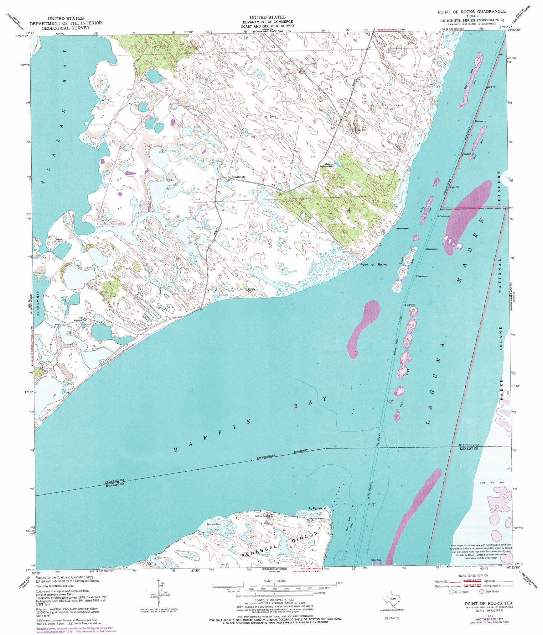
USGS Topo Quad 27097c4 - 1:24,000 scale
| Topo Map Name: | Point Of Rocks |
| USGS Topo Quad ID: | 27097c4 |
| Print Size: | ca. 21 1/4" wide x 27" high |
| Southeast Coordinates: | 27.25° N latitude / 97.375° W longitude |
| Map Center Coordinates: | 27.3125° N latitude / 97.4375° W longitude |
| U.S. State: | TX |
| Filename: | o27097c4.jpg |
| Download Map JPG Image: | Point Of Rocks topo map 1:24,000 scale |
| Map Type: | Topographic |
| Topo Series: | 7.5´ |
| Map Scale: | 1:24,000 |
| Source of Map Images: | United States Geological Survey (USGS) |
| Alternate Map Versions: |
Point Of Rocks TX 1951, updated 1953 Download PDF Buy paper map Point Of Rocks TX 1951, updated 1978 Download PDF Buy paper map Point of Rocks TX 2010 Download PDF Buy paper map Point of Rocks TX 2013 Download PDF Buy paper map Point of Rocks TX 2016 Download PDF Buy paper map |
1:24,000 Topo Quads surrounding Point Of Rocks
Concordia |
Laureles Ranch |
Chapman Ranch |
Pita Island |
Crane Islands Sw |
Riviera Beach Nw |
Riviera Beach Ne |
South Bird Island Nw |
South Bird Island |
|
Riviera Beach |
Kleberg Point |
Point Of Rocks |
South Bird Island Se |
|
La Parra Ranch |
La Parra Ranch Ne |
Yarborough Pass |
||
La Parra Ranch Sw |
La Parra Ranch Se |
Potrero Cortado |
> Back to 27097a1 at 1:100,000 scale
> Back to 27096a1 at 1:250,000 scale
> Back to U.S. Topo Maps home
Point Of Rocks topo map: Gazetteer
Point Of Rocks: Capes
Penascal Rincon elevation 1m 3′Point of Rocks elevation 1m 3′
Point Penascal elevation 1m 3′
Point Of Rocks: Channels
Compuerta elevation 1m 3′Point Of Rocks: Populated Places
El Martillo elevation 1m 3′Point Of Rocks: Wells
Calbero Artesian Well elevation 4m 13′El Tule Artesian Well elevation 1m 3′
Point Of Rocks digital topo map on disk
Buy this Point Of Rocks topo map showing relief, roads, GPS coordinates and other geographical features, as a high-resolution digital map file on DVD: