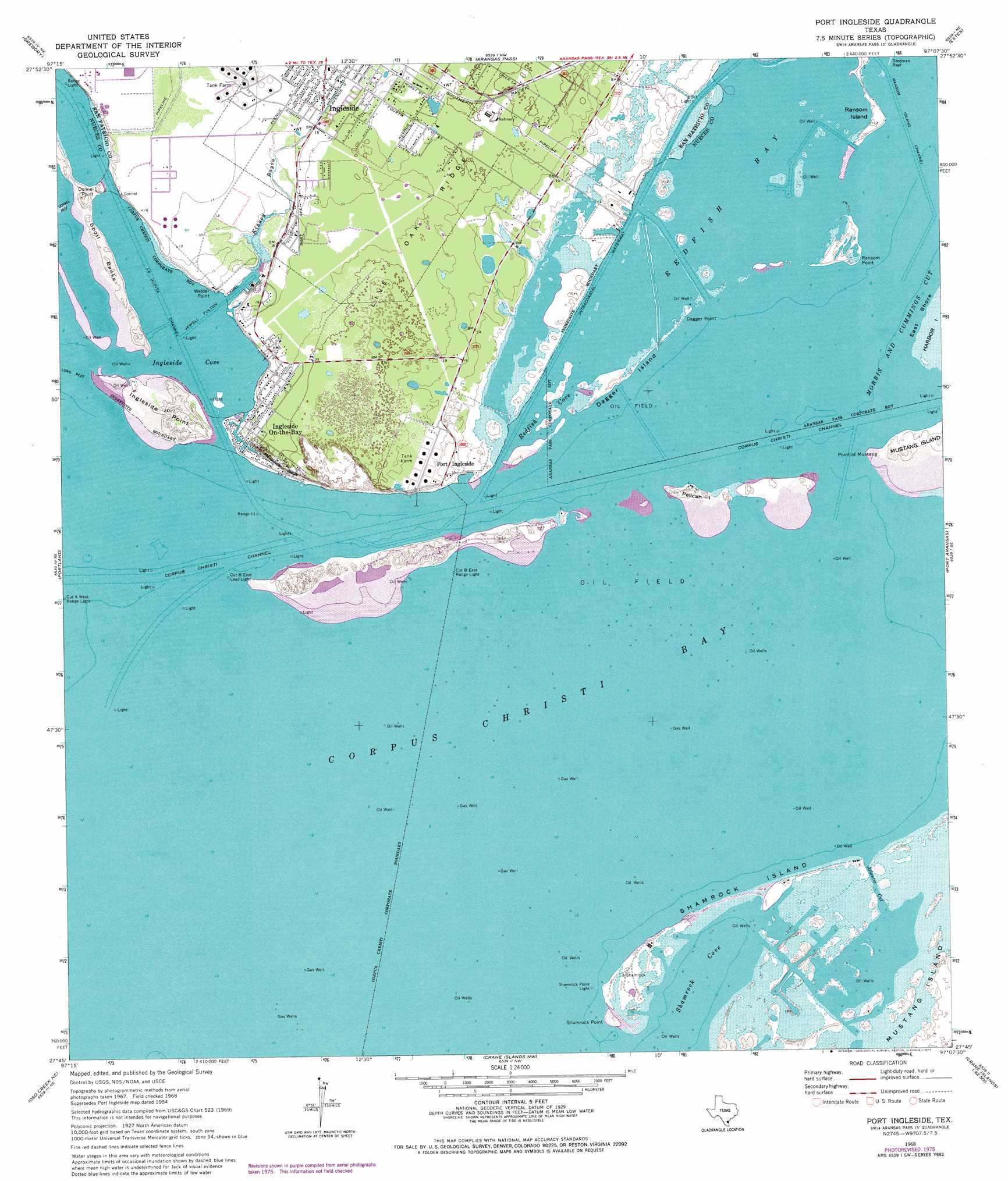
Port Ingleside Topo Map Texas
To zoom in, hover over the map of Port Ingleside
USGS Topo Quad 27097g2 - 1:24,000 scale
| Topo Map Name: | Port Ingleside |
| USGS Topo Quad ID: | 27097g2 |
| Print Size: | ca. 21 1/4" wide x 27" high |
| Southeast Coordinates: | 27.75° N latitude / 97.125° W longitude |
| Map Center Coordinates: | 27.8125° N latitude / 97.1875° W longitude |
| U.S. State: | TX |
| Filename: | o27097g2.jpg |
| Download Map JPG Image: | Port Ingleside topo map 1:24,000 scale |
| Map Type: | Topographic |
| Topo Series: | 7.5´ |
| Map Scale: | 1:24,000 |
| Source of Map Images: | United States Geological Survey (USGS) |
| Alternate Map Versions: |
Port Ingleside TX 1954, updated 1956 Download PDF Buy paper map Port Ingleside TX 1968, updated 1971 Download PDF Buy paper map Port Ingleside TX 1968, updated 1977 Download PDF Buy paper map Port Ingleside TX 2010 Download PDF Buy paper map Port Ingleside TX 2013 Download PDF Buy paper map Port Ingleside TX 2016 Download PDF Buy paper map |
1:24,000 Topo Quads surrounding Port Ingleside
Sinton East |
Rincon Bend |
Bayside |
Rockport |
Saint Charles Bay Sw |
Taft |
Gregory |
Aransas Pass |
Estes |
Allyns Bight |
Corpus Christi |
Portland |
Port Ingleside |
Port Aransas |
|
Oso Creek Nw |
Oso Creek Ne |
Crane Islands Nw |
||
Chapman Ranch |
Pita Island |
Crane Islands Sw |
> Back to 27097e1 at 1:100,000 scale
> Back to 27096a1 at 1:250,000 scale
> Back to U.S. Topo Maps home
Port Ingleside topo map: Gazetteer
Port Ingleside: Airports
Arco Ingleside Shorebase Heliport elevation 0m 0′Ingleside Offshore Services Heliport elevation 6m 19′
Navsta Ingleside Heliport elevation 7m 22′
Oak Ridge Heliport elevation 6m 19′
Port Ingleside: Basins
Sting Ray Hole elevation 0m 0′Port Ingleside: Bays
Ingleside Cove elevation 0m 0′Little Shamrock Cove elevation 0m 0′
Pink Shack Cove elevation 0m 0′
Redfish Cove elevation 0m 0′
Shamrock Cove elevation 0m 0′
Port Ingleside: Canals
Jewell Fulton Canal elevation 0m 0′Port Ingleside: Capes
Dagger Point elevation 0m 0′Donnel Point elevation 4m 13′
Ingleside Point elevation 5m 16′
Point of Mustang elevation 1m 3′
Ransom Point elevation 1m 3′
Shamrock Point elevation 1m 3′
Welder Point elevation 3m 9′
Port Ingleside: Channels
Atlantic Channel elevation 0m 0′Atlantic Cut elevation 0m 0′
Corpus Christi Channel elevation 0m 0′
La Quinta Channel elevation 0m 0′
Ransom Island Channel elevation 0m 0′
Sinclair Cut elevation 0m 0′
Port Ingleside: Cliffs
McGloins Bluff elevation 7m 22′Port Ingleside: Islands
Cooks Island elevation 0m 0′Dagger Island elevation 1m 3′
Pelican Island elevation 1m 3′
Ransom Island elevation 2m 6′
Shamrock Island elevation 0m 0′
Port Ingleside: Populated Places
Caruthers Cove Colonia elevation 6m 19′Garza-4th-6th Streets Colonia elevation 7m 22′
Harbor City (historical) elevation 3m 9′
Indian Trails Lane Colonia elevation 7m 22′
Ingleside On-the-Bay elevation 3m 9′
Old Ingleside Colonia elevation 4m 13′
Port Ingleside elevation 3m 9′
Wendy Acres Colonia elevation 5m 16′
Port Ingleside: Slopes
Green Shack Cove elevation 0m 0′Port Ingleside: Streams
Kinney Bayou elevation 0m 0′Port Ingleside digital topo map on disk
Buy this Port Ingleside topo map showing relief, roads, GPS coordinates and other geographical features, as a high-resolution digital map file on DVD: