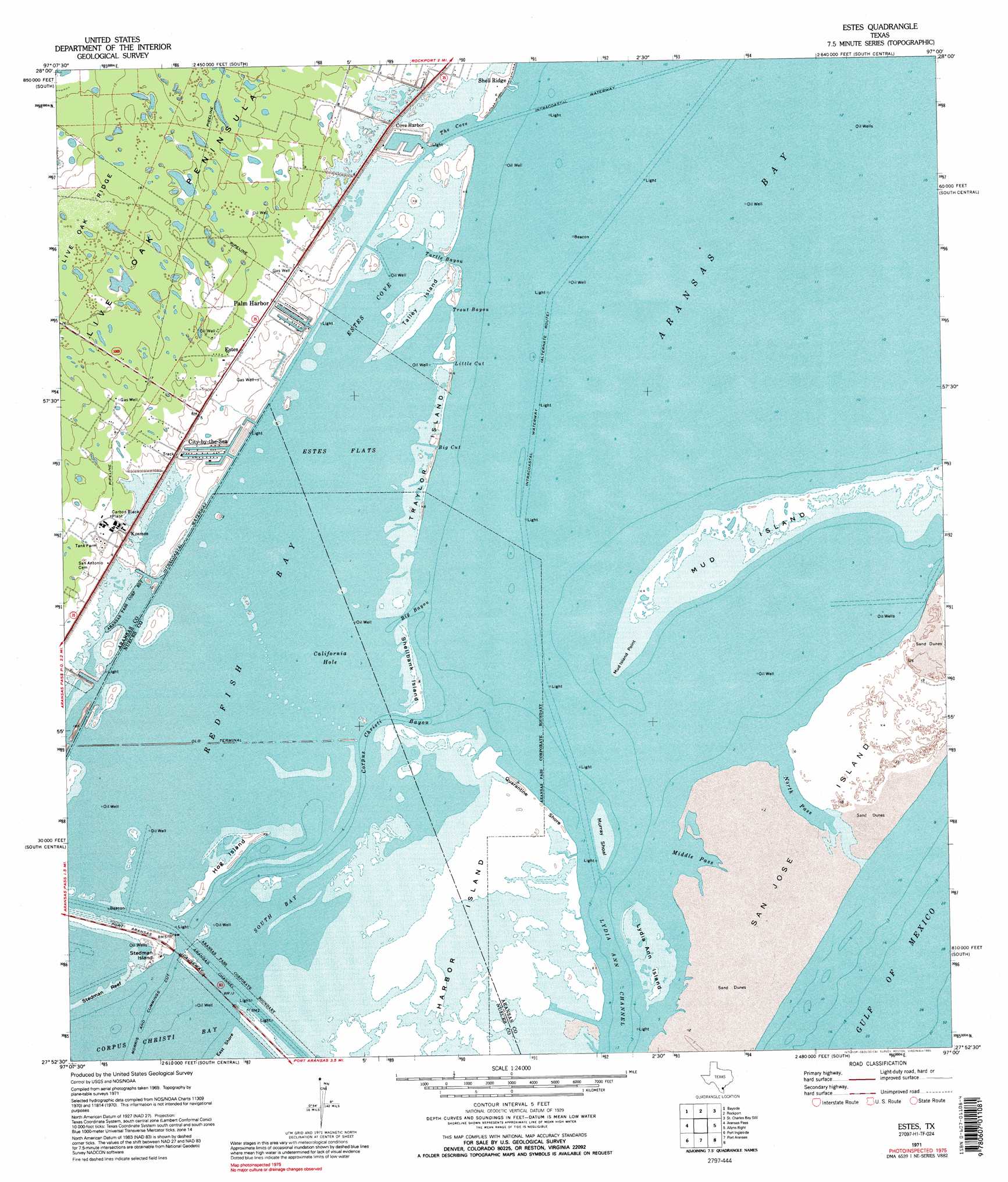
Estes Topo Map Texas
To zoom in, hover over the map of Estes
USGS Topo Quad 27097h1 - 1:24,000 scale
| Topo Map Name: | Estes |
| USGS Topo Quad ID: | 27097h1 |
| Print Size: | ca. 21 1/4" wide x 27" high |
| Southeast Coordinates: | 27.875° N latitude / 97° W longitude |
| Map Center Coordinates: | 27.9375° N latitude / 97.0625° W longitude |
| U.S. State: | TX |
| Filename: | o27097h1.jpg |
| Download Map JPG Image: | Estes topo map 1:24,000 scale |
| Map Type: | Topographic |
| Topo Series: | 7.5´ |
| Map Scale: | 1:24,000 |
| Source of Map Images: | United States Geological Survey (USGS) |
| Alternate Map Versions: |
Estes TX 1954, updated 1956 Download PDF Buy paper map Estes TX 1971, updated 1973 Download PDF Buy paper map Estes TX 1971, updated 1985 Download PDF Buy paper map Estes TX 1971, updated 1995 Download PDF Buy paper map Estes TX 2010 Download PDF Buy paper map Estes TX 2013 Download PDF Buy paper map Estes TX 2016 Download PDF Buy paper map |
1:24,000 Topo Quads surrounding Estes
Woodsboro |
Mission Bay |
Lamar |
Saint Charles Bay |
Mesquite Bay |
Rincon Bend |
Bayside |
Rockport |
Saint Charles Bay Sw |
Saint Charles Bay Se |
Gregory |
Aransas Pass |
Estes |
Allyns Bight |
|
Portland |
Port Ingleside |
Port Aransas |
||
Oso Creek Ne |
Crane Islands Nw |
> Back to 27097e1 at 1:100,000 scale
> Back to 27096a1 at 1:250,000 scale
> Back to U.S. Topo Maps home
Estes topo map: Gazetteer
Estes: Airports
Mobil-Rockport Heliport elevation 2m 6′Estes: Bars
Muray Shoal elevation 0m 0′Estes: Bays
California Hole elevation 0m 0′Estes Cove elevation 0m 0′
Middle Pass elevation 0m 0′
Redfish Bay elevation 0m 0′
South Bay elevation 0m 0′
The Cove elevation 0m 0′
Estes: Beaches
Quarantine Shore elevation 0m 0′Estes: Capes
Mudisland Point elevation 0m 0′Estes: Channels
Big Bayou elevation 0m 0′Big Cut elevation 0m 0′
Corpus Christi Bayou elevation 0m 0′
Little Cut elevation 0m 0′
North Pass elevation 4m 13′
Trout Bayou elevation 0m 0′
Turtle Bayou elevation 0m 0′
Estes: Flats
Estes Flats elevation 0m 0′Estes: Islands
Hog Island elevation 1m 3′Lydia Ann Island elevation 1m 3′
Mud Island elevation 1m 3′
Shellbank Island elevation 0m 0′
Stedman Island elevation 1m 3′
Talley Island elevation 1m 3′
Traylor Island elevation 0m 0′
Estes: Populated Places
City-by-the Sea elevation 1m 3′Estes elevation 2m 6′
Palm Harbor elevation 1m 3′
Shell Ridge elevation 0m 0′
Estes digital topo map on disk
Buy this Estes topo map showing relief, roads, GPS coordinates and other geographical features, as a high-resolution digital map file on DVD: