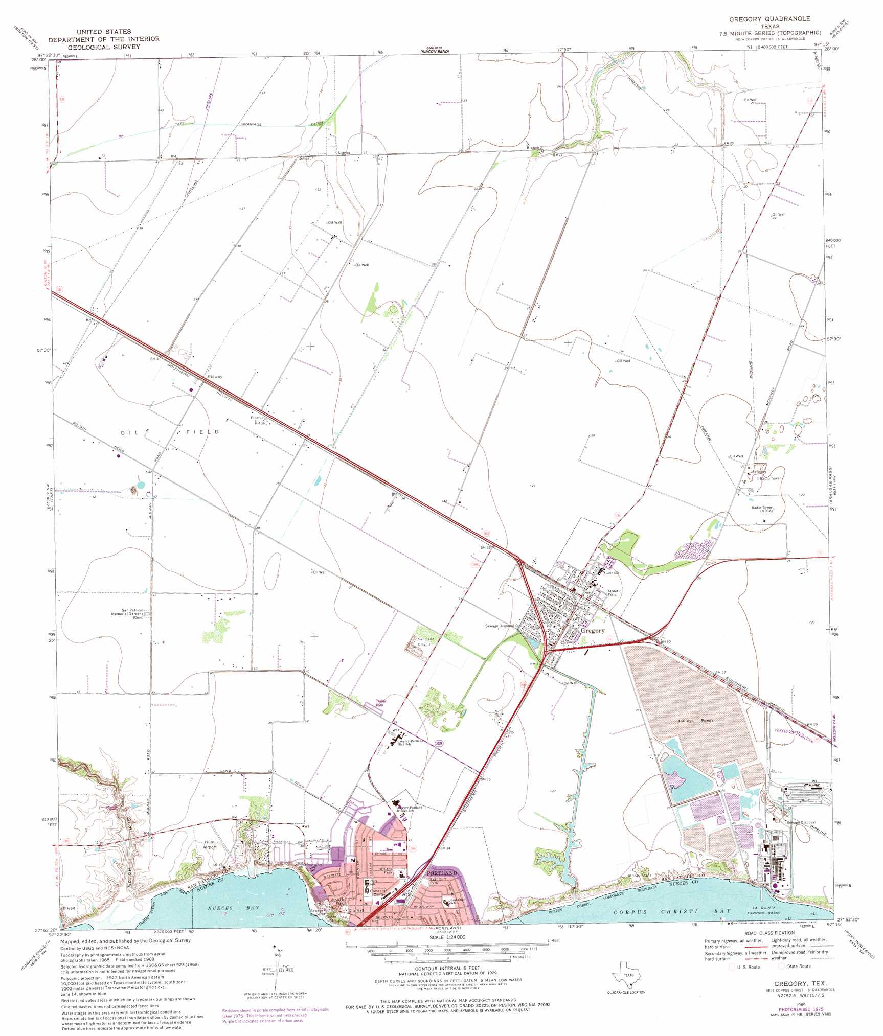
Gregory Topo Map Texas
To zoom in, hover over the map of Gregory
USGS Topo Quad 27097h3 - 1:24,000 scale
| Topo Map Name: | Gregory |
| USGS Topo Quad ID: | 27097h3 |
| Print Size: | ca. 21 1/4" wide x 27" high |
| Southeast Coordinates: | 27.875° N latitude / 97.25° W longitude |
| Map Center Coordinates: | 27.9375° N latitude / 97.3125° W longitude |
| U.S. State: | TX |
| Filename: | o27097h3.jpg |
| Download Map JPG Image: | Gregory topo map 1:24,000 scale |
| Map Type: | Topographic |
| Topo Series: | 7.5´ |
| Map Scale: | 1:24,000 |
| Source of Map Images: | United States Geological Survey (USGS) |
| Alternate Map Versions: |
Gregory TX 1969, updated 1972 Download PDF Buy paper map Gregory TX 1969, updated 1977 Download PDF Buy paper map Gregory TX 1969, updated 1977 Download PDF Buy paper map Gregory TX 1969, updated 1977 Download PDF Buy paper map Gregory TX 2010 Download PDF Buy paper map Gregory TX 2013 Download PDF Buy paper map Gregory TX 2016 Download PDF Buy paper map |
1:24,000 Topo Quads surrounding Gregory
Papalote |
Cranell |
Woodsboro |
Mission Bay |
Lamar |
Sinton West |
Sinton East |
Rincon Bend |
Bayside |
Rockport |
Odem |
Taft |
Gregory |
Aransas Pass |
Estes |
Annaville |
Corpus Christi |
Portland |
Port Ingleside |
Port Aransas |
Petronila Ne |
Oso Creek Nw |
Oso Creek Ne |
Crane Islands Nw |
> Back to 27097e1 at 1:100,000 scale
> Back to 27096a1 at 1:250,000 scale
> Back to U.S. Topo Maps home
Gregory topo map: Gazetteer
Gregory: Airports
Hunt Airport elevation 12m 39′Gregory: Canals
Taft Drainage Ditch elevation 11m 36′Gregory: Dams
Reynolds Metal Company Reservoir Dam elevation 7m 22′Gregory: Harbors
La Quinta Turning Basin elevation 0m 0′Gregory: Parks
Baker Park elevation 9m 29′Broadway Park elevation 4m 13′
East Cliff Park elevation 10m 32′
Hunt Municipal Park elevation 11m 36′
Wildcat Stadium elevation 11m 36′
Willacy Park elevation 11m 36′
Gregory: Populated Places
Crescent Center elevation 13m 42′Doyle elevation 6m 19′
Doyle Addition Colonia elevation 9m 29′
Gregory elevation 9m 29′
Midway elevation 12m 39′
Nueces Bay Colonia elevation 10m 32′
Nueces Bayfront Colonia elevation 1m 3′
Portland elevation 13m 42′
Tradewinds elevation 6m 19′
Tradewinds Estates Colonia elevation 6m 19′
Gregory: Reservoirs
Reynolds Metal Company Reservoir elevation 7m 22′Gregory: Valleys
Gum Hollow elevation 1m 3′Gregory digital topo map on disk
Buy this Gregory topo map showing relief, roads, GPS coordinates and other geographical features, as a high-resolution digital map file on DVD: