Orange Grove Topo Map Texas
To zoom in, hover over the map of Orange Grove
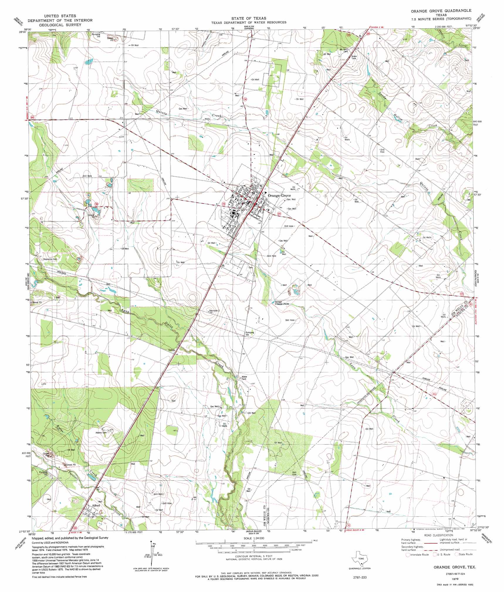
USGS Topo Quad 27097h8 - 1:24,000 scale
| Topo Map Name: | Orange Grove |
| USGS Topo Quad ID: | 27097h8 |
| Print Size: | ca. 21 1/4" wide x 27" high |
| Southeast Coordinates: | 27.875° N latitude / 97.875° W longitude |
| Map Center Coordinates: | 27.9375° N latitude / 97.9375° W longitude |
| U.S. State: | TX |
| Filename: | o27097h8.jpg |
| Download Map JPG Image: | Orange Grove topo map 1:24,000 scale |
| Map Type: | Topographic |
| Topo Series: | 7.5´ |
| Map Scale: | 1:24,000 |
| Source of Map Images: | United States Geological Survey (USGS) |
| Alternate Map Versions: |
Orange Grove TX 1979, updated 1991 Download PDF Buy paper map Orange Grove TX 2010 Download PDF Buy paper map Orange Grove TX 2013 Download PDF Buy paper map Orange Grove TX 2016 Download PDF Buy paper map |
1:24,000 Topo Quads surrounding Orange Grove
Elm Creek |
Crater Ridge |
Dinero |
Tynan |
Bullshead Creek |
Anna Rose |
Midway |
Sandia |
Mathis |
West Sinton |
Shaeffer Ranch |
San Diego Ne |
Orange Grove |
San Patricio |
Edroy |
San Diego |
Alice North |
Agua Dulce |
Banquete |
Robstown |
Ben Bolt Nw |
Alice South |
Kingsville Nw |
Driscoll West |
Driscoll East |
> Back to 27097e1 at 1:100,000 scale
> Back to 27096a1 at 1:250,000 scale
> Back to U.S. Topo Maps home
Orange Grove topo map: Gazetteer
Orange Grove: Populated Places
Alfred elevation 50m 164′Alfred Acres Colonia elevation 47m 154′
Alfred Hilltop Estates Colonia elevation 52m 170′
Casa Linda Colonia elevation 65m 213′
Colony Estates Colonia elevation 66m 216′
El Camino Al Lago Colonia elevation 57m 187′
Heritage Acres Colonia elevation 48m 157′
Heritage Acres Number 2 Colonia elevation 50m 164′
Johns Valley Colonia elevation 59m 193′
K-Bar Ranch elevation 59m 193′
K-Bar-J Estates Colonia elevation 54m 177′
Koehn Estates Colonia elevation 62m 203′
Mi Tierra Colonia elevation 61m 200′
North Alfred Colonia elevation 51m 167′
North Orange Estates Colonia elevation 63m 206′
Orange Acres Colonia elevation 56m 183′
Orange Blossom Estates Colonia elevation 63m 206′
Orange Grove elevation 59m 193′
Orange Grove Villa Colonia elevation 52m 170′
Orange Valley Estates Colonia elevation 63m 206′
R and R Colonia elevation 61m 200′
Rolling Acres Colonia elevation 41m 134′
Rolling Acres Estates Colonia elevation 62m 203′
Roth Estates Colonia elevation 55m 180′
Sandy Bluff Colonia elevation 39m 127′
Silver Spur Estates Colonia elevation 59m 193′
South La Paloma Estates Colonia elevation 54m 177′
West Orange Estates Colonia elevation 64m 209′
Westdale elevation 65m 213′
Westdale Estates Number 1 Colonia elevation 62m 203′
Westdale Estates Number 2 Colonia elevation 62m 203′
Westdale Estates Number 3 Colonia elevation 65m 213′
Westdale Estates Number 4 Colonia elevation 63m 206′
Yucca Acres Colonia elevation 44m 144′
Orange Grove: Streams
Ruces Creek elevation 44m 144′Orange Grove digital topo map on disk
Buy this Orange Grove topo map showing relief, roads, GPS coordinates and other geographical features, as a high-resolution digital map file on DVD: