Biel Lake North Topo Map Texas
To zoom in, hover over the map of Biel Lake North
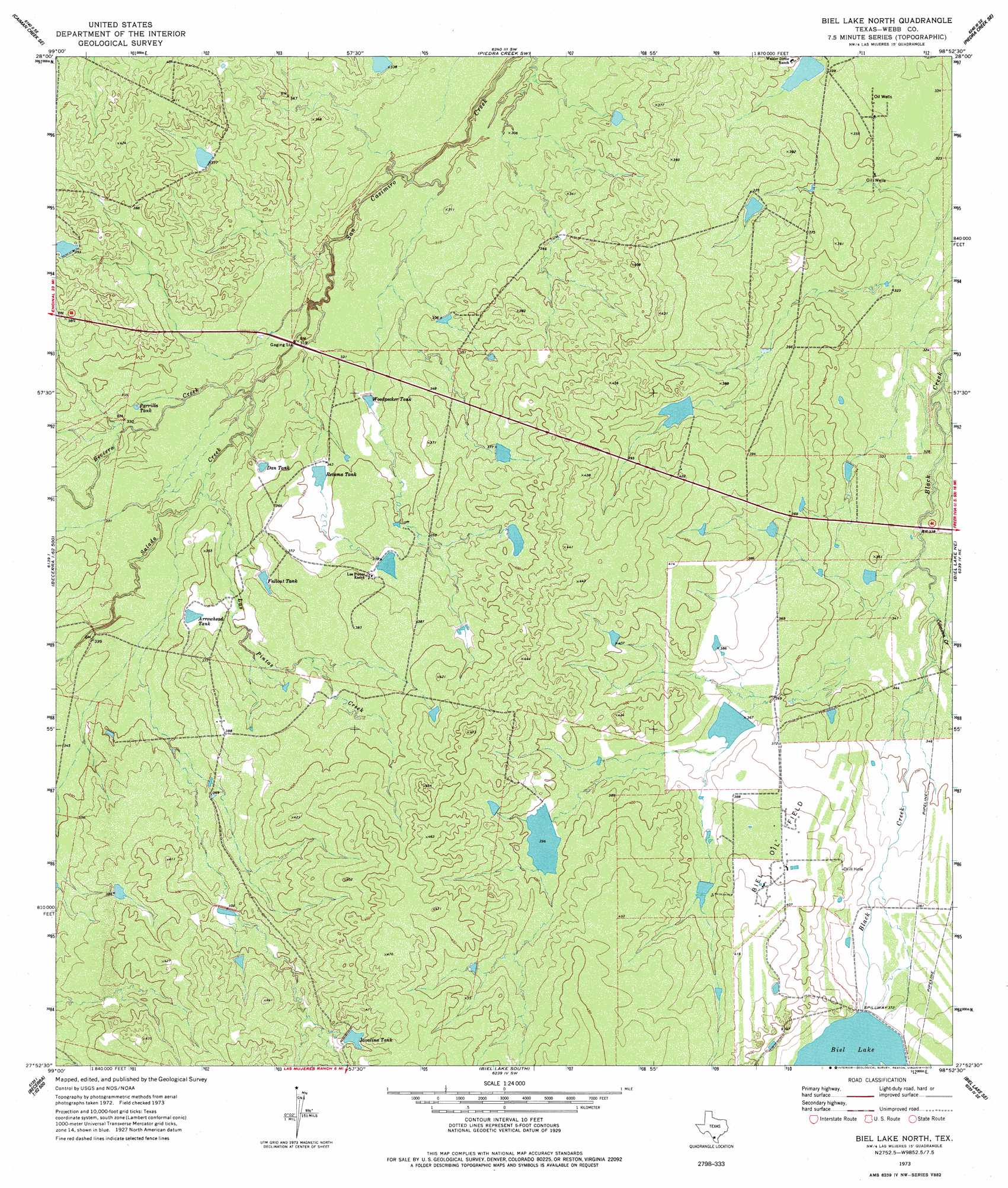
USGS Topo Quad 27098h8 - 1:24,000 scale
| Topo Map Name: | Biel Lake North |
| USGS Topo Quad ID: | 27098h8 |
| Print Size: | ca. 21 1/4" wide x 27" high |
| Southeast Coordinates: | 27.875° N latitude / 98.875° W longitude |
| Map Center Coordinates: | 27.9375° N latitude / 98.9375° W longitude |
| U.S. State: | TX |
| Filename: | o27098h8.jpg |
| Download Map JPG Image: | Biel Lake North topo map 1:24,000 scale |
| Map Type: | Topographic |
| Topo Series: | 7.5´ |
| Map Scale: | 1:24,000 |
| Source of Map Images: | United States Geological Survey (USGS) |
| Alternate Map Versions: |
Biel Lake North TX 1973, updated 1977 Download PDF Buy paper map Biel Lake North TX 2010 Download PDF Buy paper map Biel Lake North TX 2013 Download PDF Buy paper map Biel Lake North TX 2016 Download PDF Buy paper map |
1:24,000 Topo Quads surrounding Biel Lake North
Caiman Creek Nw |
Caiman Creek Ne |
Piedra Creek Nw |
Piedra Creek Ne |
Loma Alta Nw |
Live Oak Creek |
Caiman Creek Se |
Piedra Creek Sw |
Piedra Creek Se |
Mirasol Creek |
Venado Creek East |
Alamito Creek Ne |
Biel Lake North |
Biel Lake Ne |
Freer Nw |
Pato Creek |
Alamito Creek |
Biel Lake South |
Biel Lake Se |
Sarnosa Hill |
Piedra Parada Tank |
Piedra Parada Ranch |
Mills Bennett Nw |
Mills Bennett |
Parrilla Creek Nw |
> Back to 27098e1 at 1:100,000 scale
> Back to 27098a1 at 1:250,000 scale
> Back to U.S. Topo Maps home
Biel Lake North topo map: Gazetteer
Biel Lake North: Oilfields
Biel Oil Field elevation 121m 396′Biel Lake North: Reservoirs
Arrowhead Tank elevation 107m 351′Biel Lake elevation 113m 370′
Dan Tank elevation 104m 341′
Fallout Tank elevation 110m 360′
Parrilla Tank elevation 101m 331′
Retama Tank elevation 104m 341′
Woodpecker Tank elevation 101m 331′
Biel Lake North: Streams
Becerra Creek elevation 94m 308′Colmena Creek elevation 102m 334′
Las Pintas Creek elevation 100m 328′
Salado Creek elevation 94m 308′
Biel Lake North digital topo map on disk
Buy this Biel Lake North topo map showing relief, roads, GPS coordinates and other geographical features, as a high-resolution digital map file on DVD: