Titusville Topo Map Florida
To zoom in, hover over the map of Titusville
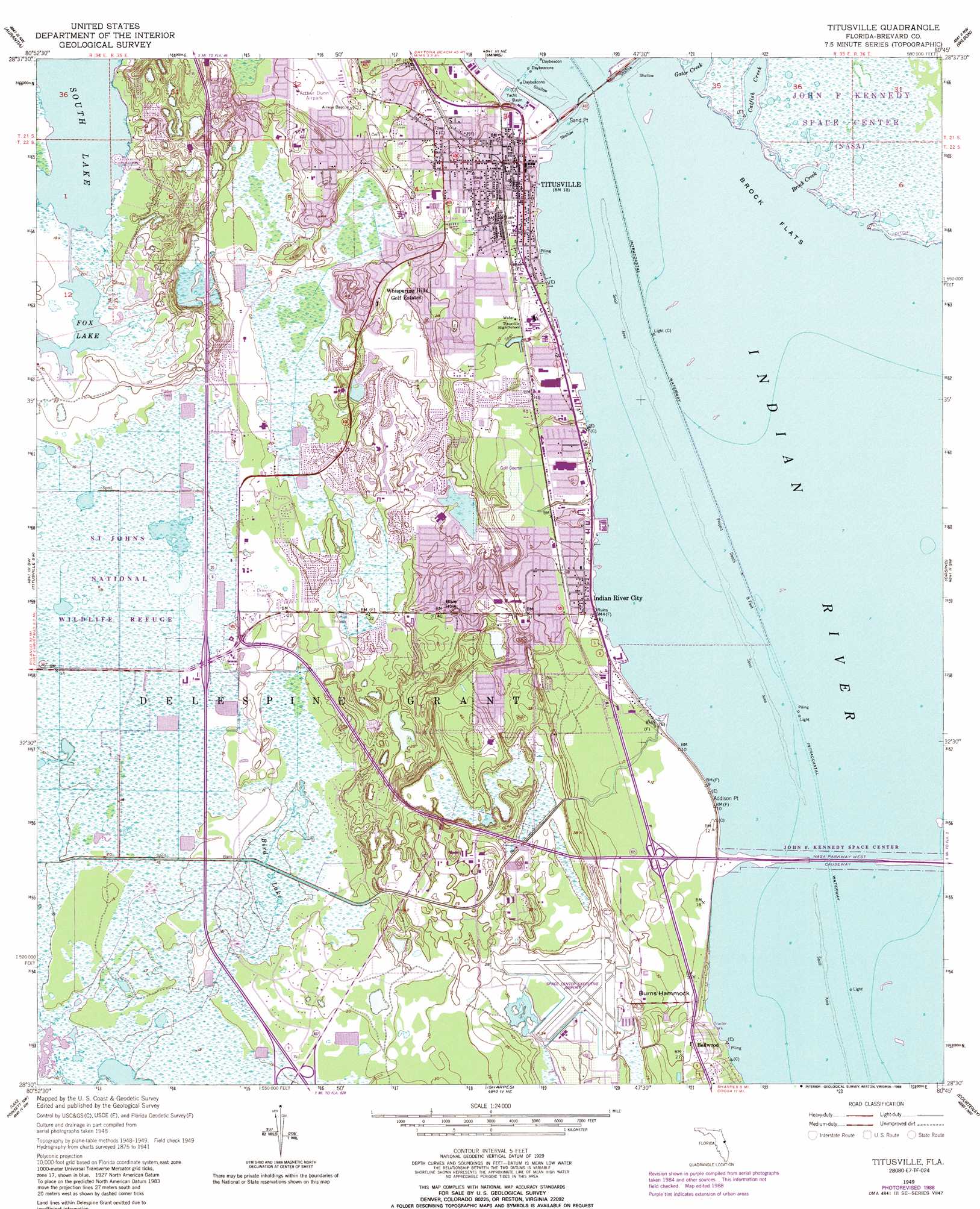
USGS Topo Quad 28080e7 - 1:24,000 scale
| Topo Map Name: | Titusville |
| USGS Topo Quad ID: | 28080e7 |
| Print Size: | ca. 21 1/4" wide x 27" high |
| Southeast Coordinates: | 28.5° N latitude / 80.75° W longitude |
| Map Center Coordinates: | 28.5625° N latitude / 80.8125° W longitude |
| U.S. State: | FL |
| Filename: | O28080E7.jpg |
| Download Map JPG Image: | Titusville topo map 1:24,000 scale |
| Map Type: | Topographic |
| Topo Series: | 7.5´ |
| Map Scale: | 1:24,000 |
| Source of Map Images: | United States Geological Survey (USGS) |
| Alternate Map Versions: |
Titusville FL 1949, updated 1960 Download PDF Buy paper map Titusville FL 1949, updated 1968 Download PDF Buy paper map Titusville FL 1949, updated 1972 Download PDF Buy paper map Titusville FL 1949, updated 1981 Download PDF Buy paper map Titusville FL 1949, updated 1984 Download PDF Buy paper map Titusville FL 1949, updated 1988 Download PDF Buy paper map Titusville FL 1952 Download PDF Buy paper map Titusville FL 2012 Download PDF Buy paper map Titusville FL 2015 Download PDF Buy paper map |
1:24,000 Topo Quads surrounding Titusville
Osceola |
Maytown |
Oak Hill |
Pardon Island |
|
Geneva |
Aurantia |
Mims |
Wilson |
|
Bithlo |
Titusville Sw |
Titusville |
Orsino |
False Cape |
Narcoossee Ne |
Lake Poinsett Nw |
Sharpes |
Courtenay |
Cape Canaveral |
Narcoossee Se |
Lake Poinsett Sw |
Lake Poinsett |
Cocoa |
Cocoa Beach |
> Back to 28080e1 at 1:100,000 scale
> Back to 28080a1 at 1:250,000 scale
> Back to U.S. Topo Maps home
Titusville topo map: Gazetteer
Titusville: Airports
Arthur Dunn Air Park elevation 9m 29′Space Center Executive Airport elevation 10m 32′
Titusville: Basins
Blue Hole elevation 10m 32′Titusville: Bays
Brock Creek elevation 0m 0′Titusville: Bridges
NASA Parkway West Causeway elevation 0m 0′Titusville: Capes
Addison Point elevation 1m 3′Sand Point elevation 0m 0′
Titusville: Flats
Brock Flats elevation 0m 0′Titusville: Islands
Burns Hammock elevation 10m 32′Titusville: Lakes
Fox Lake elevation 4m 13′South Lake elevation 4m 13′
Titusville: Parks
Fox Lake Park elevation 6m 19′Parrish Park elevation 1m 3′
Titusville: Populated Places
April Estates Mobile Home Park elevation 6m 19′Bellwood elevation 6m 19′
Briarwood Mobile Home Park elevation 1m 3′
Cherrydon Mobile Home Park elevation 1m 3′
Dixie Mobile Home Park elevation 7m 22′
Indian River City elevation 3m 9′
Manatee Hammock Park Mobile Home Park elevation 2m 6′
Nelson Trailer Park elevation 1m 3′
Oak Point Mobile Park elevation 4m 13′
Osceola Trailer Park elevation 7m 22′
Palm Harbor Mobile Home Park elevation 4m 13′
River Forest Mobile Home Park elevation 2m 6′
Riverview Trailer Park elevation 2m 6′
Silver Breeze Mobile Home Community elevation 11m 36′
South Titusville elevation 11m 36′
Titusville elevation 3m 9′
Whispering Hills Golf Estates elevation 10m 32′
Whispering Pines Mobile Home Park elevation 6m 19′
Titusville: Post Offices
Astronaut Trail Post Office elevation 1m 3′Indian River City Post Office elevation 8m 26′
Titusville Post Office elevation 1m 3′
Titusville Station Post Office elevation 6m 19′
Titusville: Streams
Addison Creek elevation 0m 0′Catfish Creek elevation 0m 0′
Gator Creek elevation 0m 0′
Titusville: Swamps
Bird Lake elevation 7m 22′Titusville digital topo map on disk
Buy this Titusville topo map showing relief, roads, GPS coordinates and other geographical features, as a high-resolution digital map file on DVD: