Holopaw Se Topo Map Florida
To zoom in, hover over the map of Holopaw Se
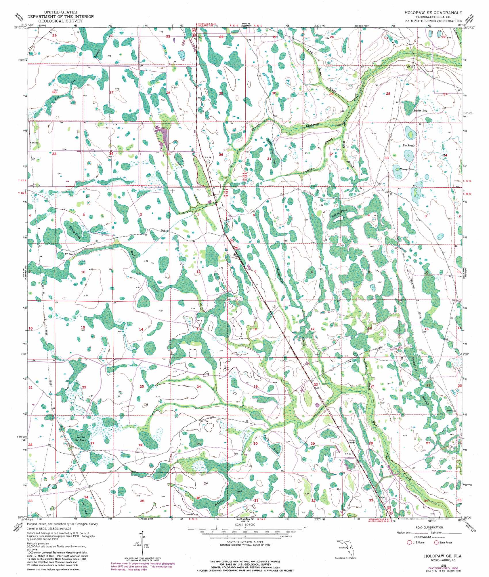
USGS Topo Quad 28081a1 - 1:24,000 scale
| Topo Map Name: | Holopaw Se |
| USGS Topo Quad ID: | 28081a1 |
| Print Size: | ca. 21 1/4" wide x 27" high |
| Southeast Coordinates: | 28° N latitude / 81° W longitude |
| Map Center Coordinates: | 28.0625° N latitude / 81.0625° W longitude |
| U.S. State: | FL |
| Filename: | O28081A1.jpg |
| Download Map JPG Image: | Holopaw Se topo map 1:24,000 scale |
| Map Type: | Topographic |
| Topo Series: | 7.5´ |
| Map Scale: | 1:24,000 |
| Source of Map Images: | United States Geological Survey (USGS) |
| Alternate Map Versions: |
Holopaw SE FL 1953, updated 1954 Download PDF Buy paper map Holopaw SE FL 1953, updated 1963 Download PDF Buy paper map Holopaw SE FL 1953, updated 1979 Download PDF Buy paper map Holopaw SE FL 1953, updated 1981 Download PDF Buy paper map Holopaw SE FL 2012 Download PDF Buy paper map Holopaw SE FL 2015 Download PDF Buy paper map |
1:24,000 Topo Quads surrounding Holopaw Se
Saint Cloud North |
Narcoossee |
Narcoossee Se |
Lake Poinsett Sw |
Lake Poinsett |
Saint Cloud South |
Ashton |
Holopaw |
Deer Park Nw |
Deer Park Ne |
Cypress Lake |
Holopaw Sw |
Holopaw Se |
Deer Park |
Deer Park Se |
Lake Weohyakapka Ne |
Lake Marian Nw |
Lake Marian Ne |
Kenansville |
Kenansville Ne |
Lake Weohyakpka Se |
Lake Marian Sw |
Lake Marian Se |
Kenansville Sw |
Kenansville Se |
> Back to 28081a1 at 1:100,000 scale
> Back to 28080a1 at 1:250,000 scale
> Back to U.S. Topo Maps home
Holopaw Se topo map: Gazetteer
Holopaw Se: Airports
Tedford Ranch Airport elevation 19m 62′Holopaw Se: Guts
Sawgrass Slough elevation 19m 62′Holopaw Se: Lakes
Bee Ponds elevation 20m 65′Clump Pond elevation 20m 65′
Ox Pond elevation 23m 75′
Holopaw Se: Streams
Boggy Branch elevation 15m 49′Cabbage Slough elevation 16m 52′
Little Creek elevation 19m 62′
Little North Prong elevation 15m 49′
Rattlesnake Slough elevation 18m 59′
Turkey Slough elevation 17m 55′
Holopaw Se: Swamps
Grape Head Pond elevation 20m 65′Hog Pen Slough elevation 24m 78′
Island Pond elevation 19m 62′
Johnson Bay elevation 20m 65′
North Ox Pond elevation 23m 75′
Oakey Pond elevation 24m 78′
Saplin Bay elevation 17m 55′
Holopaw Se digital topo map on disk
Buy this Holopaw Se topo map showing relief, roads, GPS coordinates and other geographical features, as a high-resolution digital map file on DVD: