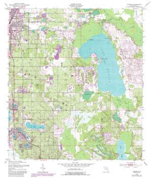
Dundee Topo Map Florida
To zoom in, hover over the map of Dundee
USGS Topo Quad 28081a5 - 1:24,000 scale
| Topo Map Name: | Dundee |
| USGS Topo Quad ID: | 28081a5 |
| Print Size: | ca. 21 1/4" wide x 27" high |
| Southeast Coordinates: | 28° N latitude / 81.5° W longitude |
| Map Center Coordinates: | 28.0625° N latitude / 81.5625° W longitude |
| U.S. State: | FL |
| Filename: | O28081A5.jpg |
| Download Map JPG Image: | Dundee topo map 1:24,000 scale |
| Map Type: | Topographic |
| Topo Series: | 7.5´ |
| Map Scale: | 1:24,000 |
| Source of Map Images: | United States Geological Survey (USGS) |
| Alternate Map Versions: |
Dundee FL 1953, updated 1954 Download PDF Buy paper map Dundee FL 1953, updated 1968 Download PDF Buy paper map Dundee FL 1953, updated 1972 Download PDF Buy paper map Dundee FL 1953, updated 1981 Download PDF Buy paper map Dundee FL 1953, updated 1987 Download PDF Buy paper map Dundee FL 1953, updated 1987 Download PDF Buy paper map Dundee FL 2012 Download PDF Buy paper map Dundee FL 2015 Download PDF Buy paper map |
1:24,000 Topo Quads surrounding Dundee
> Back to 28081a1 at 1:100,000 scale
> Back to 28080a1 at 1:250,000 scale
> Back to U.S. Topo Maps home
Dundee topo map: Gazetteer
Dundee: Airports
Southerly Airport elevation 27m 88′Dundee: Islands
Bannon Island elevation 25m 82′Snodgrass Island elevation 25m 82′
Twin Islands elevation 20m 65′
Dundee: Lakes
Lake Ada elevation 36m 118′Lake Gordon elevation 36m 118′
Lake Josephine elevation 36m 118′
Lake Marie elevation 36m 118′
Lake Marion elevation 20m 65′
Lake Menzie elevation 38m 124′
Lake Midget elevation 27m 88′
Lake Ruth elevation 36m 118′
Lake Trask elevation 33m 108′
Dundee: Parks
8 Acre Park elevation 52m 170′Cook Field elevation 44m 144′
East Park Softball Complex elevation 37m 121′
Larry Parrish Baseball Complex elevation 39m 127′
Dundee: Populated Places
Chester Dees Mobile Home Park elevation 39m 127′Dundee elevation 49m 160′
Haines City elevation 51m 167′
Oak Meadows Mobile Home Park elevation 33m 108′
Peak Haven Mobile Home Park elevation 28m 91′
Dundee: Post Offices
Dundee Post Office elevation 42m 137′Dundee: Streams
Snell Creek elevation 20m 65′Dundee: Swamps
Cowpen Bay elevation 24m 78′Indian Head Swamp elevation 21m 68′
Dundee digital topo map on disk
Buy this Dundee topo map showing relief, roads, GPS coordinates and other geographical features, as a high-resolution digital map file on DVD:


