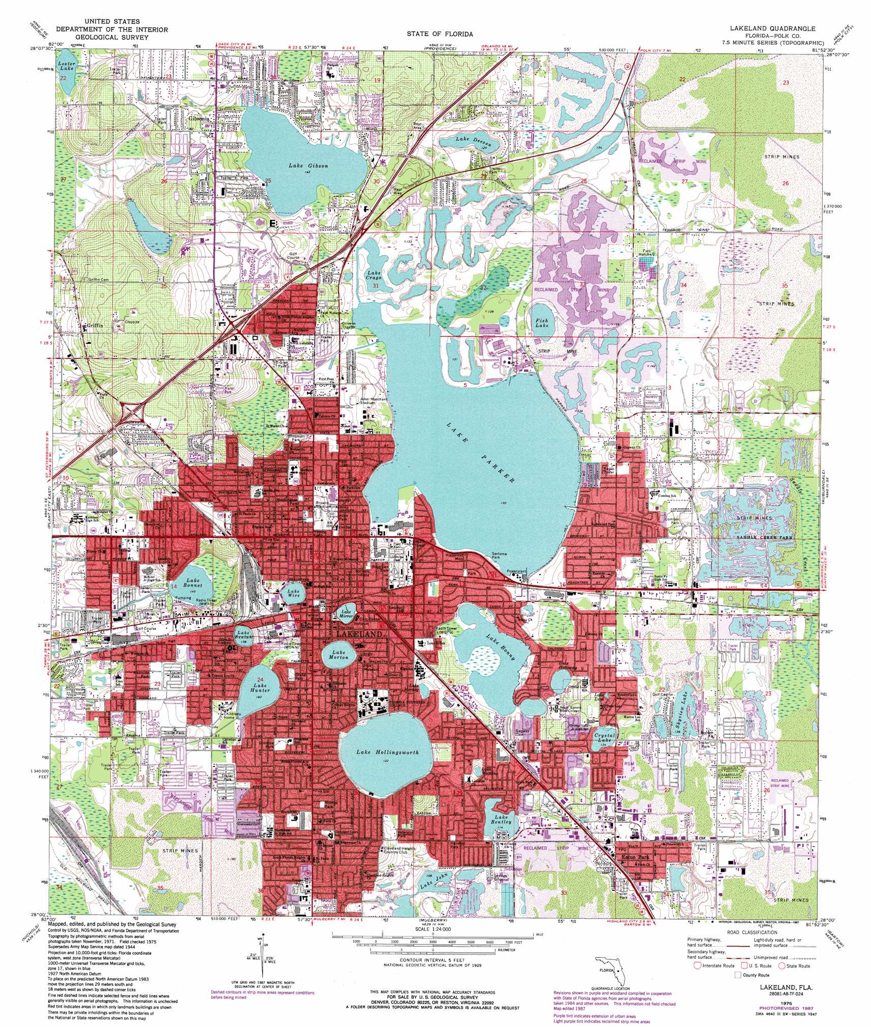
Lakeland Topo Map Florida
To zoom in, hover over the map of Lakeland
USGS Topo Quad 28081a8 - 1:24,000 scale
| Topo Map Name: | Lakeland |
| USGS Topo Quad ID: | 28081a8 |
| Print Size: | ca. 21 1/4" wide x 27" high |
| Southeast Coordinates: | 28° N latitude / 81.875° W longitude |
| Map Center Coordinates: | 28.0625° N latitude / 81.9375° W longitude |
| U.S. State: | FL |
| Filename: | O28081A8.jpg |
| Download Map JPG Image: | Lakeland topo map 1:24,000 scale |
| Map Type: | Topographic |
| Topo Series: | 7.5´ |
| Map Scale: | 1:24,000 |
| Source of Map Images: | United States Geological Survey (USGS) |
| Alternate Map Versions: |
Lakeland FL 1944, updated 1962 Download PDF Buy paper map Lakeland FL 1975, updated 1976 Download PDF Buy paper map Lakeland FL 1975, updated 1983 Download PDF Buy paper map Lakeland FL 1975, updated 1987 Download PDF Buy paper map Lakeland FL 1994, updated 2000 Download PDF Buy paper map Lakeland FL 2012 Download PDF Buy paper map Lakeland FL 2015 Download PDF Buy paper map |
1:24,000 Topo Quads surrounding Lakeland
Dade City |
Branchborough |
Rock Ridge |
Poyner |
Lake Louisa Sw |
Zephyrhills |
Socrum |
Providence |
Polk City |
Gum Lake |
Plant City West |
Plant City East |
Lakeland |
Auburndale |
Winter Haven |
Dover |
Nichols |
Mulberry |
Bartow |
Eloise |
Lithia |
Keysville |
Bradley Junction |
Homeland |
Alturas |
> Back to 28081a1 at 1:100,000 scale
> Back to 28080a1 at 1:250,000 scale
> Back to U.S. Topo Maps home
Lakeland topo map: Gazetteer
Lakeland: Airports
Florida Federal Office Building Helistop elevation 61m 200′Langford Seaplane Base elevation 43m 141′
LGH Heliport elevation 58m 190′
Littles Heliport elevation 39m 127′
White Eagle Heliport elevation 33m 108′
Lakeland: Lakes
Anglers Lake elevation 33m 108′Complex Lake elevation 42m 137′
Crystal Lake elevation 41m 134′
Fairview Lake elevation 43m 141′
Fairway Lake elevation 42m 137′
Fish Lake elevation 39m 127′
Hydrilla Lake elevation 41m 134′
Lagoon Lake elevation 42m 137′
Lake Bentley elevation 34m 111′
Lake Beulah elevation 54m 177′
Lake Bonnet elevation 44m 144′
Lake Bonny elevation 39m 127′
Lake Burbank elevation 39m 127′
Lake Crago elevation 39m 127′
Lake Deeson elevation 38m 124′
Lake Gibson elevation 43m 141′
Lake Hollingsworth elevation 40m 131′
Lake Holloway elevation 42m 137′
Lake Horney elevation 42m 137′
Lake Hunter elevation 49m 160′
Lake John elevation 33m 108′
Lake Lure elevation 47m 154′
Lake Luther elevation 45m 147′
Lake Mirror elevation 56m 183′
Lake Morton elevation 54m 177′
Lake Parker elevation 39m 127′
Lake Somerset elevation 33m 108′
Lake Watkins elevation 37m 121′
Lake Wire elevation 60m 196′
Lazy Lake elevation 33m 108′
Lester Lake elevation 39m 127′
Meadow View Lake elevation 48m 157′
Pelican Lake elevation 33m 108′
Pelican Pond elevation 33m 108′
Picnic Lake elevation 39m 127′
Sarden Lake elevation 39m 127′
Skyview Lake elevation 41m 134′
Sunshine Lake elevation 33m 108′
Lakeland: Parks
Adair Park elevation 58m 190′Bryant Stadium elevation 65m 213′
Combee Park elevation 36m 118′
Dobbins Park elevation 61m 200′
Drane Park elevation 59m 193′
Handley Park elevation 36m 118′
Henley Field elevation 66m 216′
Horney Park elevation 56m 183′
Joker Marchant Stadium elevation 48m 157′
Munn Park elevation 63m 206′
Saddle Creek Park elevation 34m 111′
Sertoma Park elevation 41m 134′
Simpson Park elevation 50m 164′
Veterans Park elevation 41m 134′
Washington Park elevation 64m 209′
Westside Park elevation 49m 160′
Lakeland: Populated Places
2505 Tanglewood Street Mobile Home Park elevation 43m 141′Al - Lee Village Mobile Home Park elevation 40m 131′
Anglers Cove Mobile Home Park elevation 35m 114′
Arizona Mobile Home Park elevation 43m 141′
Bartles Trailer Court elevation 49m 160′
Beacon Hill Colony Mobile Home Park elevation 52m 170′
Beacon Terrace Mobile Home Park elevation 50m 164′
Bethany Mobile Home Park elevation 44m 144′
Big Oak Park Mobile Home Park elevation 43m 141′
Black Bear Mobile Home Park elevation 42m 137′
Bonny Shores Mobile Home Park elevation 41m 134′
Brooks Mobile Home Park elevation 41m 134′
Brookwood Mobile Home Park elevation 40m 131′
Carol Sligar Mobile Home Park elevation 50m 164′
Citrus Center Colony Mobile Home Park elevation 50m 164′
Colonial Mobile Home Village elevation 53m 173′
Colorado Court Mobile Home Park elevation 44m 144′
Combee Settlement elevation 41m 134′
Crescent Way Trailer Park elevation 55m 180′
Croft Mobile Home Park elevation 42m 137′
Crystal Lake elevation 45m 147′
Eaton Park elevation 43m 141′
El Camba Mobile Home Park elevation 47m 154′
Elliott Mobile Home Park elevation 39m 127′
Fountainview Estates Mobile Home Park elevation 48m 157′
Foxwood Lake Mobile Home Park elevation 63m 206′
Georgetowne Mobile Manor elevation 50m 164′
Gibsonia elevation 52m 170′
Gifford Mobile Home Park elevation 43m 141′
Golden Wings Mobile Home Park elevation 60m 196′
Griffin elevation 62m 203′
Happy Hollow Mobile Home Ranch elevation 38m 124′
Heatherwood Village Mobile Home Park elevation 50m 164′
Helens Mobile Home Park elevation 47m 154′
Hickory Hills Manor Mobile Home Park elevation 51m 167′
Hilltop Mobile Home Park elevation 50m 164′
Homestead Mobile Home Park elevation 37m 121′
Hoosier Park Mobile Home Park elevation 43m 141′
Hull Street Blues Mobile Home Park elevation 52m 170′
Imperial Manor Mobile Home Terrace elevation 42m 137′
J and M Mobile Home Park elevation 46m 150′
Kings and Queens Mobile Home Park elevation 42m 137′
Kings Manor Mobile Home Park elevation 51m 167′
Lake Bonny Mobile Home Park elevation 42m 137′
Lakeland elevation 60m 196′
Lakeland Court Family Mobile Home Park elevation 52m 170′
Lakeland Estates Mobile Home Community elevation 47m 154′
Lakeland Harbor Mobile Home Park elevation 41m 134′
Lakeland Junction Mobile Home Park elevation 47m 154′
Lazy Dazy Retreat Mobile Home Park elevation 53m 173′
Lee and Dots Mobile Home Park elevation 38m 124′
Leisure Place Mobile Home Park elevation 59m 193′
Lincoln Mobile Home Park elevation 41m 134′
Lone Pine Mobile Home Park elevation 37m 121′
Mas Verde Mobile Home Estates elevation 50m 164′
May Grove Mobile Home Park elevation 55m 180′
May Manor Mobile Home Park elevation 44m 144′
Oak Hill Mobile Home Park elevation 53m 173′
Oakhill Mobile Home Park elevation 48m 157′
Oakridge Mobile Home Park elevation 45m 147′
Orangewood Village Mobile Home Park elevation 48m 157′
Peachtree Mobile Home Park elevation 45m 147′
Peachtree Park Mobile Home Park elevation 40m 131′
Penny Royal Court Mobile Home Park elevation 41m 134′
Pine Grove Mobile Home Park elevation 45m 147′
Plant Avenue Mobile Home Park elevation 50m 164′
Promise Crossing Mobile Home Park elevation 46m 150′
Rawls Park elevation 41m 134′
Richard R Trailer Park elevation 44m 144′
Sandford's Mobile Home Park elevation 43m 141′
Scenic View Mobile Home Park elevation 52m 170′
Serene Court Mobile Home Park elevation 43m 141′
Shady Oaks Mobile Home Park elevation 40m 131′
Sherwood Mobile Home Park elevation 59m 193′
Stengel Mobile Home Park elevation 51m 167′
Sterling Mobile Home Park elevation 45m 147′
Sunshine Village Mobile Home Park elevation 38m 124′
Suttons Mobile Home Park elevation 41m 134′
Tanglewood Village Adult Mobile Home Park elevation 41m 134′
Twelve Oaks Mobile Home Park elevation 49m 160′
United Trailer Park elevation 47m 154′
Warnke Mobile Home Park elevation 40m 131′
Whispering Oaks Mobile Home Community elevation 49m 160′
Windy Beach Mobile Home Park elevation 40m 131′
Woodalls Mobile Home Village elevation 45m 147′
Woodbrook Estates Mobile Home Park elevation 48m 157′
Woodland Oaks Mobile Home Park elevation 40m 131′
Lakeland: Post Offices
Dixieland Post Office elevation 60m 196′Lake Hamilton Post Office elevation 63m 206′
Lakeland Downtown Station Post Office elevation 63m 206′
Lakeland digital topo map on disk
Buy this Lakeland topo map showing relief, roads, GPS coordinates and other geographical features, as a high-resolution digital map file on DVD: