Saint Cloud South Topo Map Florida
To zoom in, hover over the map of Saint Cloud South
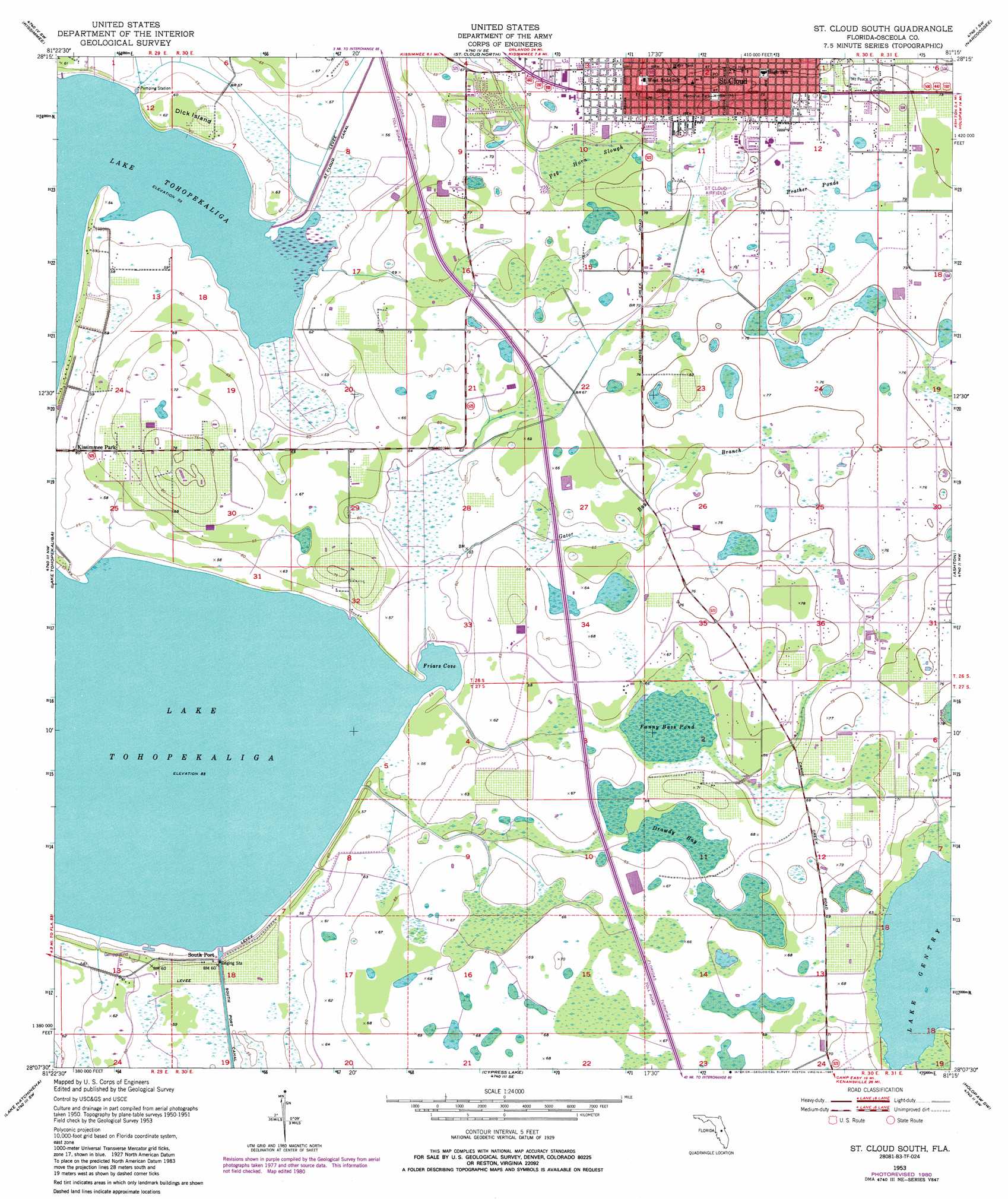
USGS Topo Quad 28081b3 - 1:24,000 scale
| Topo Map Name: | Saint Cloud South |
| USGS Topo Quad ID: | 28081b3 |
| Print Size: | ca. 21 1/4" wide x 27" high |
| Southeast Coordinates: | 28.125° N latitude / 81.25° W longitude |
| Map Center Coordinates: | 28.1875° N latitude / 81.3125° W longitude |
| U.S. State: | FL |
| Filename: | O28081B3.jpg |
| Download Map JPG Image: | Saint Cloud South topo map 1:24,000 scale |
| Map Type: | Topographic |
| Topo Series: | 7.5´ |
| Map Scale: | 1:24,000 |
| Source of Map Images: | United States Geological Survey (USGS) |
| Alternate Map Versions: |
St Cloud South FL 1953, updated 1954 Download PDF Buy paper map St Cloud South FL 1953, updated 1966 Download PDF Buy paper map St Cloud South FL 1953, updated 1972 Download PDF Buy paper map St. Cloud South FL 1953, updated 1981 Download PDF Buy paper map St Cloud South FL 1953, updated 1987 Download PDF Buy paper map Saint Cloud South FL 2012 Download PDF Buy paper map Saint Cloud South FL 2015 Download PDF Buy paper map |
1:24,000 Topo Quads surrounding Saint Cloud South
Windermere |
Lake Jessamine |
Pine Castle |
Narcoossee Nw |
Narcoossee Ne |
Intercession City |
Kissimmee |
Saint Cloud North |
Narcoossee |
Narcoossee Se |
Davenport |
Lake Tohopekaliga |
Saint Cloud South |
Ashton |
Holopaw |
Dundee |
Lake Hatchineha |
Cypress Lake |
Holopaw Sw |
Holopaw Se |
Lake Wales |
Hesperides |
Lake Weohyakapka Ne |
Lake Marian Nw |
Lake Marian Ne |
> Back to 28081a1 at 1:100,000 scale
> Back to 28080a1 at 1:250,000 scale
> Back to U.S. Topo Maps home
Saint Cloud South topo map: Gazetteer
Saint Cloud South: Airports
Gentry Airport elevation 20m 65′Saint Cloud Hospital Heliport elevation 21m 68′
Saint Cloud South: Bays
Friars Cove elevation 16m 52′Saint Cloud South: Guts
Gator Bay Branch elevation 21m 68′Saint Cloud South: Islands
Dick Island elevation 19m 62′Saint Cloud South: Populated Places
Covington Estates Mobile Home Park elevation 23m 75′Davis Island Mobile Home Park elevation 22m 72′
Golden Grove Mobile Home Park elevation 23m 75′
Mark Mobile Home Park elevation 21m 68′
Saint Cloud elevation 23m 75′
Saint Cloud Trailer Park elevation 23m 75′
South Port elevation 17m 55′
Times Trailer Park elevation 21m 68′
Saint Cloud South: Swamps
Drawdy Bay elevation 19m 62′Fanny Bass Pond elevation 19m 62′
Peg Horn Slough elevation 21m 68′
Prather Ponds elevation 23m 75′
Saint Cloud South digital topo map on disk
Buy this Saint Cloud South topo map showing relief, roads, GPS coordinates and other geographical features, as a high-resolution digital map file on DVD: