Gum Lake Topo Map Florida
To zoom in, hover over the map of Gum Lake
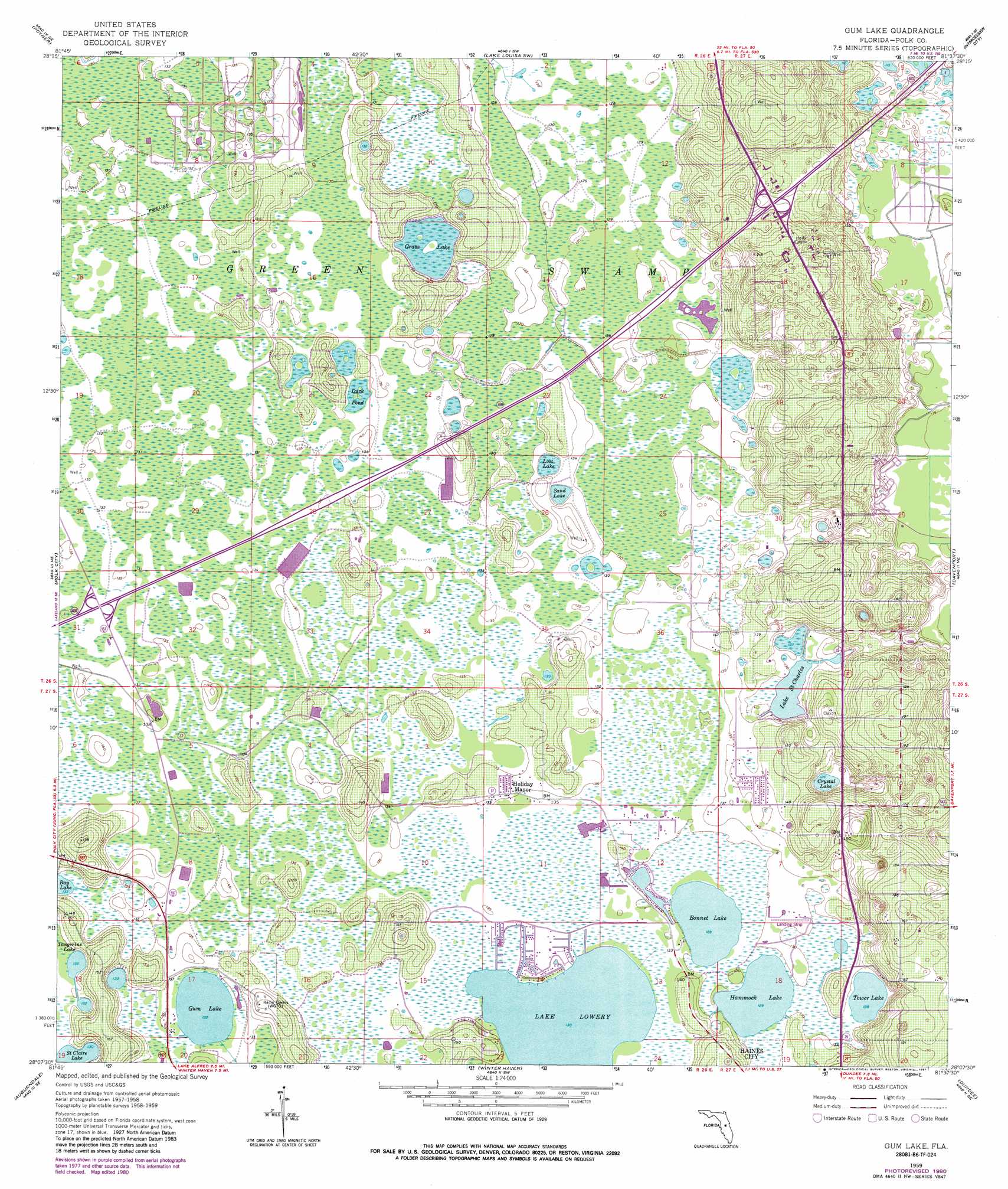
USGS Topo Quad 28081b6 - 1:24,000 scale
| Topo Map Name: | Gum Lake |
| USGS Topo Quad ID: | 28081b6 |
| Print Size: | ca. 21 1/4" wide x 27" high |
| Southeast Coordinates: | 28.125° N latitude / 81.625° W longitude |
| Map Center Coordinates: | 28.1875° N latitude / 81.6875° W longitude |
| U.S. State: | FL |
| Filename: | O28081B6.jpg |
| Download Map JPG Image: | Gum Lake topo map 1:24,000 scale |
| Map Type: | Topographic |
| Topo Series: | 7.5´ |
| Map Scale: | 1:24,000 |
| Source of Map Images: | United States Geological Survey (USGS) |
| Alternate Map Versions: |
Gum Lake FL 1959, updated 1960 Download PDF Buy paper map Gum Lake FL 1959, updated 1969 Download PDF Buy paper map Gum Lake FL 1959, updated 1972 Download PDF Buy paper map Gum Lake FL 1959, updated 1981 Download PDF Buy paper map Gum Lake FL 1959, updated 1987 Download PDF Buy paper map Gum Lake FL 2012 Download PDF Buy paper map Gum Lake FL 2015 Download PDF Buy paper map |
1:24,000 Topo Quads surrounding Gum Lake
Bay Lake |
Lake Nellie |
Lake Louisa |
Windermere |
Lake Jessamine |
Rock Ridge |
Poyner |
Lake Louisa Sw |
Intercession City |
Kissimmee |
Providence |
Polk City |
Gum Lake |
Davenport |
Lake Tohopekaliga |
Lakeland |
Auburndale |
Winter Haven |
Dundee |
Lake Hatchineha |
Mulberry |
Bartow |
Eloise |
Lake Wales |
Hesperides |
> Back to 28081a1 at 1:100,000 scale
> Back to 28080a1 at 1:250,000 scale
> Back to U.S. Topo Maps home
Gum Lake topo map: Gazetteer
Gum Lake: Airports
Gore Airport elevation 40m 131′Heart of Florida Medical Center Heliport elevation 50m 164′
Oak Harbor Seaplane Base elevation 39m 127′
Gum Lake: Lakes
Bay Lake elevation 40m 131′Bonnet Lake elevation 39m 127′
Crystal Lake elevation 38m 124′
Duck Pond elevation 40m 131′
Grass Lake elevation 40m 131′
Grassy Lake elevation 40m 131′
Gum Lake elevation 40m 131′
Hammock Lake elevation 39m 127′
Lake Brooks elevation 40m 131′
Lake Lowery elevation 39m 127′
Lake Saint Charles elevation 38m 124′
Lost Lake elevation 38m 124′
Saint Claire Lake elevation 39m 127′
Sand Lake elevation 38m 124′
Tangerine Lake elevation 40m 131′
Tower Lake elevation 39m 127′
Gum Lake: Populated Places
Blue Heron Bay Mobile Home Park elevation 40m 131′Clair Mar Mobile Home Park elevation 45m 147′
Diamond Acres Mobile Park elevation 44m 144′
Emerald Lake Mobile Home Park elevation 39m 127′
Holiday Manor elevation 41m 134′
Lake Hammock Village elevation 41m 134′
Village of la Casa del Sol Mobile Home Park elevation 44m 144′
Windmill Village Mobile Home Park elevation 53m 173′
Gum Lake digital topo map on disk
Buy this Gum Lake topo map showing relief, roads, GPS coordinates and other geographical features, as a high-resolution digital map file on DVD: