Polk City Topo Map Florida
To zoom in, hover over the map of Polk City
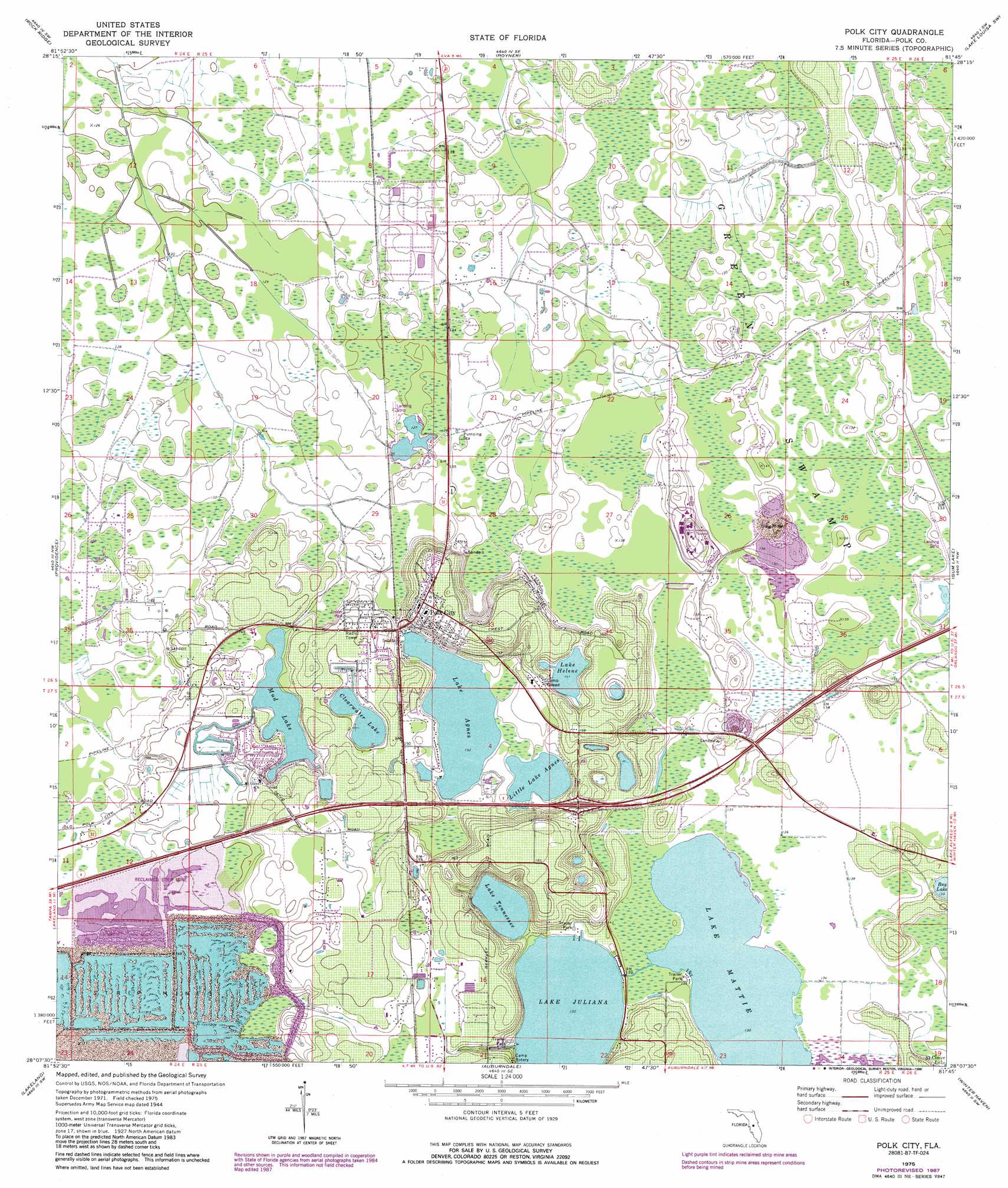
USGS Topo Quad 28081b7 - 1:24,000 scale
| Topo Map Name: | Polk City |
| USGS Topo Quad ID: | 28081b7 |
| Print Size: | ca. 21 1/4" wide x 27" high |
| Southeast Coordinates: | 28.125° N latitude / 81.75° W longitude |
| Map Center Coordinates: | 28.1875° N latitude / 81.8125° W longitude |
| U.S. State: | FL |
| Filename: | O28081B7.jpg |
| Download Map JPG Image: | Polk City topo map 1:24,000 scale |
| Map Type: | Topographic |
| Topo Series: | 7.5´ |
| Map Scale: | 1:24,000 |
| Source of Map Images: | United States Geological Survey (USGS) |
| Alternate Map Versions: |
Polk City FL 1944, updated 1963 Download PDF Buy paper map Polk City FL 1975, updated 1976 Download PDF Buy paper map Polk City FL 1975, updated 1988 Download PDF Buy paper map Polk City FL 2012 Download PDF Buy paper map Polk City FL 2015 Download PDF Buy paper map |
1:24,000 Topo Quads surrounding Polk City
Clay Sink |
Bay Lake |
Lake Nellie |
Lake Louisa |
Windermere |
Branchborough |
Rock Ridge |
Poyner |
Lake Louisa Sw |
Intercession City |
Socrum |
Providence |
Polk City |
Gum Lake |
Davenport |
Plant City East |
Lakeland |
Auburndale |
Winter Haven |
Dundee |
Nichols |
Mulberry |
Bartow |
Eloise |
Lake Wales |
> Back to 28081a1 at 1:100,000 scale
> Back to 28080a1 at 1:250,000 scale
> Back to U.S. Topo Maps home
Polk City topo map: Gazetteer
Polk City: Airports
Cherokee Ranch Airport elevation 39m 127′Flanders Field elevation 39m 127′
Worlds Greatest Aircraft Collection Airport elevation 42m 137′
Polk City: Lakes
Clearwater Lake elevation 43m 141′Lake Agnes elevation 40m 131′
Lake Helene elevation 43m 141′
Lake Juliana elevation 39m 127′
Lake Mattie elevation 39m 127′
Lake Tennessee elevation 39m 127′
Little Lake Agnes elevation 40m 131′
Mud Lake elevation 41m 134′
Polk City: Parks
Fantasy of Flight elevation 0m 0′Polk City: Populated Places
Grant Estates Mobile Home Park elevation 55m 180′Lake Juliana Landings Mobile Home Estates elevation 46m 150′
Lake Mattie Mobile Home Park elevation 40m 131′
Marker Road Mobile Home Park elevation 53m 173′
Polk City elevation 52m 170′
Polk City: Swamps
Green Swamp elevation 39m 127′Lake Mattie Marsh elevation 40m 131′
Polk City digital topo map on disk
Buy this Polk City topo map showing relief, roads, GPS coordinates and other geographical features, as a high-resolution digital map file on DVD: