Kissimmee Topo Map Florida
To zoom in, hover over the map of Kissimmee
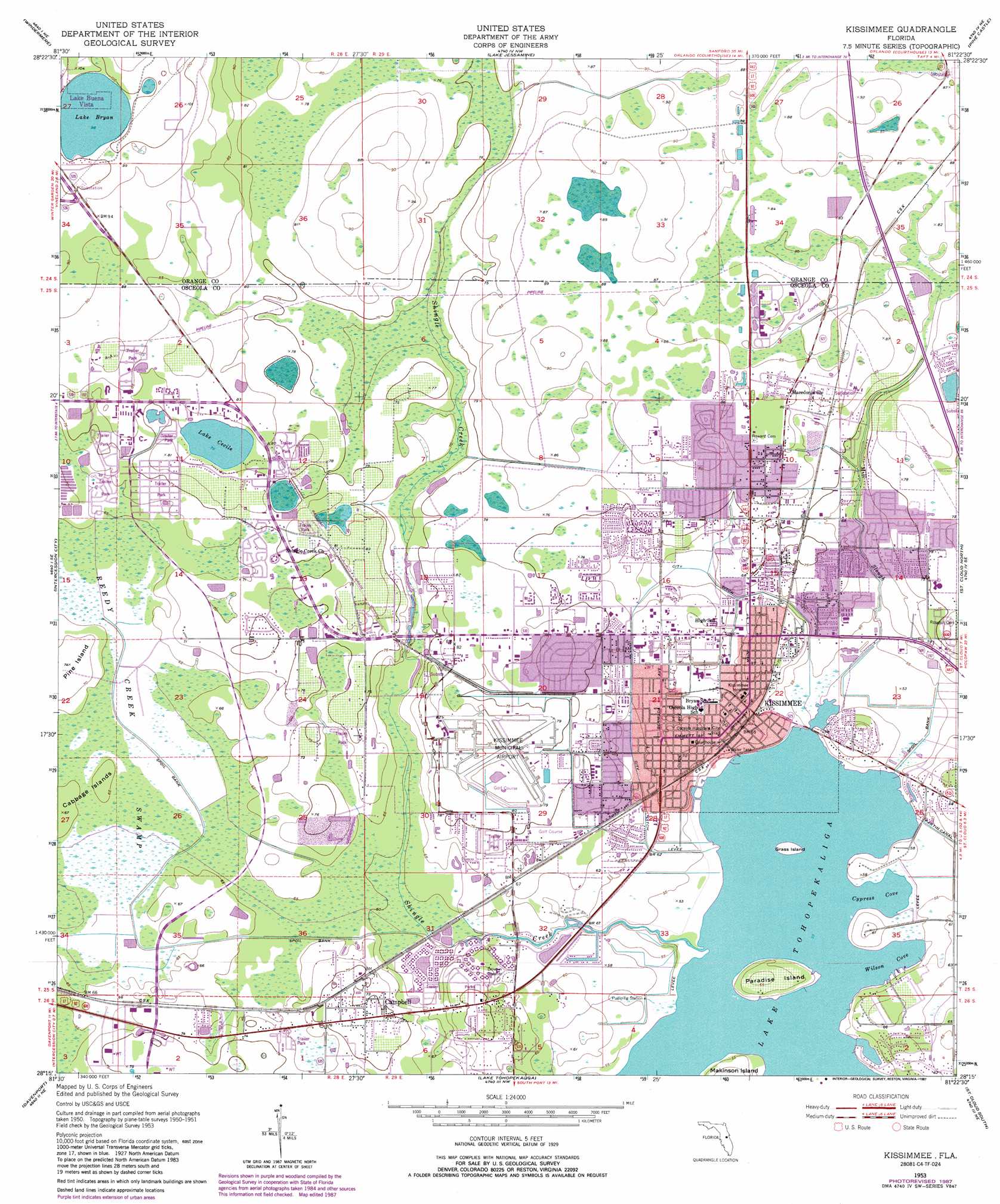
USGS Topo Quad 28081c4 - 1:24,000 scale
| Topo Map Name: | Kissimmee |
| USGS Topo Quad ID: | 28081c4 |
| Print Size: | ca. 21 1/4" wide x 27" high |
| Southeast Coordinates: | 28.25° N latitude / 81.375° W longitude |
| Map Center Coordinates: | 28.3125° N latitude / 81.4375° W longitude |
| U.S. State: | FL |
| Filename: | O28081C4.jpg |
| Download Map JPG Image: | Kissimmee topo map 1:24,000 scale |
| Map Type: | Topographic |
| Topo Series: | 7.5´ |
| Map Scale: | 1:24,000 |
| Source of Map Images: | United States Geological Survey (USGS) |
| Alternate Map Versions: |
Kissimmee FL 1953, updated 1955 Download PDF Buy paper map Kissimmee FL 1953, updated 1965 Download PDF Buy paper map Kissimmee FL 1953, updated 1972 Download PDF Buy paper map Kissimmee FL 1953, updated 1981 Download PDF Buy paper map Kissimmee FL 1953, updated 1987 Download PDF Buy paper map Kissimmee FL 2012 Download PDF Buy paper map Kissimmee FL 2015 Download PDF Buy paper map |
1:24,000 Topo Quads surrounding Kissimmee
Clermont East |
Winter Garden |
Orlando West |
Orlando East |
Oviedo Sw |
Lake Louisa |
Windermere |
Lake Jessamine |
Pine Castle |
Narcoossee Nw |
Lake Louisa Sw |
Intercession City |
Kissimmee |
Saint Cloud North |
Narcoossee |
Gum Lake |
Davenport |
Lake Tohopekaliga |
Saint Cloud South |
Ashton |
Winter Haven |
Dundee |
Lake Hatchineha |
Cypress Lake |
Holopaw Sw |
> Back to 28081a1 at 1:100,000 scale
> Back to 28080a1 at 1:250,000 scale
> Back to U.S. Topo Maps home
Kissimmee topo map: Gazetteer
Kissimmee: Airports
America's Chopper Pilots Heliport elevation 22m 72′Coles Seaplane Base elevation 19m 62′
Falcon Number Four Heliport elevation 25m 82′
Kissimmee Memorial Hospital Heliport elevation 20m 65′
Kissimmee Municipal Airport elevation 24m 78′
Osceola Regional Hospital Heliport elevation 20m 65′
Robards Number Two Heliport elevation 22m 72′
Stout Airport elevation 20m 65′
Toho Seaplane Base elevation 16m 52′
Kissimmee: Bays
Cypress Cove elevation 16m 52′Wilson Cove elevation 16m 52′
Kissimmee: Islands
Cabbage Island elevation 20m 65′Grass Island elevation 16m 52′
Paradise Island elevation 19m 62′
Pine Island elevation 22m 72′
Kissimmee: Lakes
Lake Bryan elevation 30m 98′Lake Cecile elevation 23m 75′
Kissimmee: Populated Places
Bermuda Mobile Home Park elevation 24m 78′Campbell elevation 23m 75′
Country Life Family Mobile Home Park elevation 22m 72′
El Tonteriam Court Mobile Home Park elevation 19m 62′
Highlands Mobile Home Park elevation 24m 78′
Hunters Creek elevation 27m 88′
Jackson Square Mobile Home Park elevation 22m 72′
Kings Mobile Home Park elevation 23m 75′
Kissimmee elevation 20m 65′
Kissimmee Gardens Mobile Home Park elevation 24m 78′
Lamplighter Mobile Park elevation 24m 78′
Osceola Mobile Park elevation 25m 82′
Pine Lake Mobile Home Park elevation 21m 68′
Shady Oaks Park Mobile Home Park elevation 24m 78′
Siesta Lago Mobile Home Village elevation 22m 72′
Sun Friendly Community Village Mobile Home Park elevation 23m 75′
Teels Mobile Home Park elevation 21m 68′
Tip Top Mobile Home Park elevation 22m 72′
Wagon Wheel Mobile Home Park elevation 21m 68′
Whispering Oaks Mobile Home Park elevation 21m 68′
Whispering Pines Mobile Home Park elevation 23m 75′
Windsor Mobile Home Village elevation 21m 68′
Kissimmee: Post Offices
Good Samaritan Post Office elevation 19m 62′Kissimmee Post Office elevation 23m 75′
Oak Street Post Office elevation 21m 68′
Kissimmee: Streams
Mill Slough elevation 16m 52′Shingle Creek elevation 16m 52′
Kissimmee digital topo map on disk
Buy this Kissimmee topo map showing relief, roads, GPS coordinates and other geographical features, as a high-resolution digital map file on DVD: