Oviedo Sw Topo Map Florida
To zoom in, hover over the map of Oviedo Sw
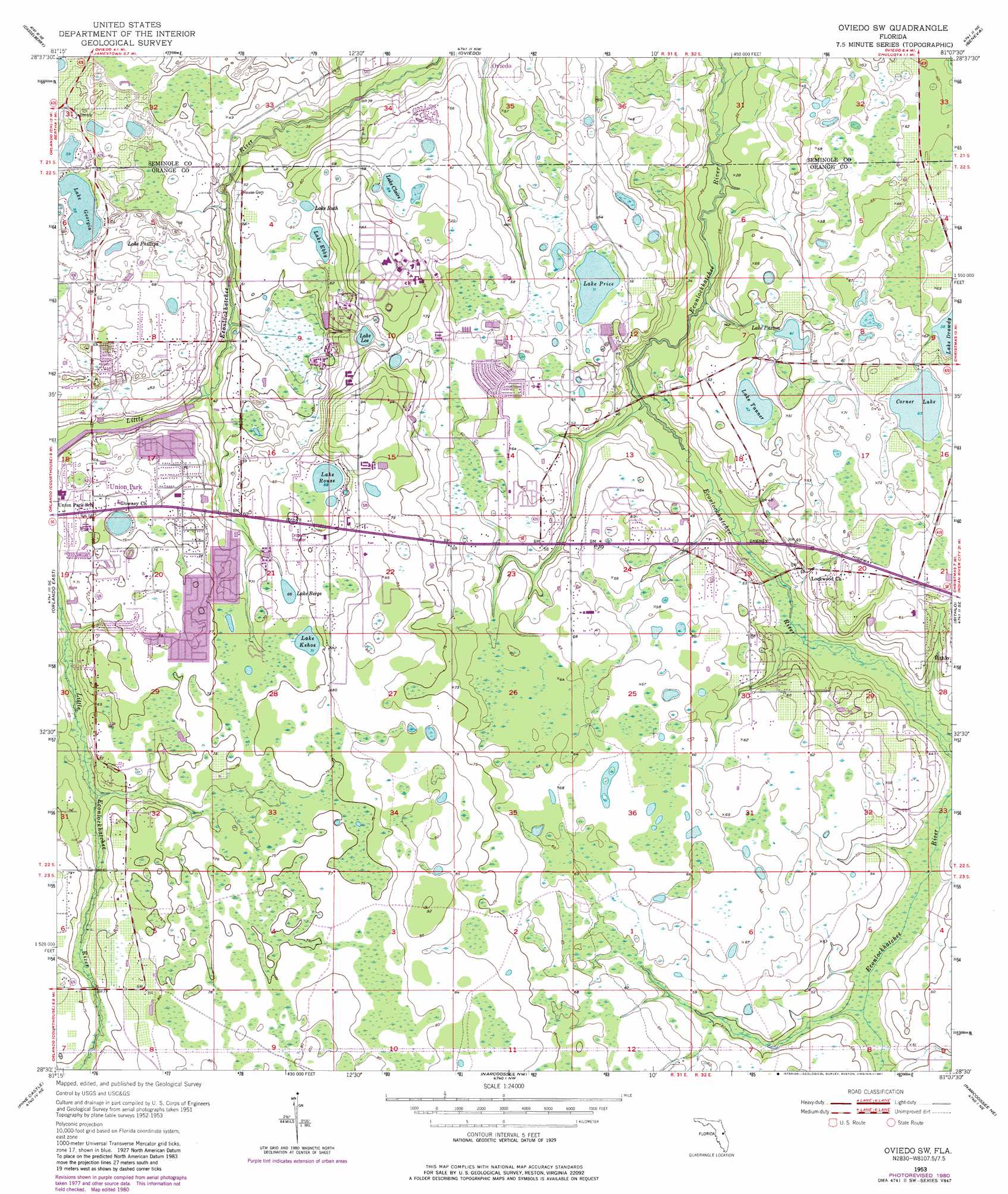
USGS Topo Quad 28081e2 - 1:24,000 scale
| Topo Map Name: | Oviedo Sw |
| USGS Topo Quad ID: | 28081e2 |
| Print Size: | ca. 21 1/4" wide x 27" high |
| Southeast Coordinates: | 28.5° N latitude / 81.125° W longitude |
| Map Center Coordinates: | 28.5625° N latitude / 81.1875° W longitude |
| U.S. State: | FL |
| Filename: | O28081E2.jpg |
| Download Map JPG Image: | Oviedo Sw topo map 1:24,000 scale |
| Map Type: | Topographic |
| Topo Series: | 7.5´ |
| Map Scale: | 1:24,000 |
| Source of Map Images: | United States Geological Survey (USGS) |
| Alternate Map Versions: |
Oviedo SW FL 1953, updated 1955 Download PDF Buy paper map Oviedo SW FL 1953, updated 1964 Download PDF Buy paper map Oviedo SW FL 1953, updated 1972 Download PDF Buy paper map Oviedo SW FL 1953, updated 1981 Download PDF Buy paper map Oviedo SW FL 2012 Download PDF Buy paper map Oviedo SW FL 2015 Download PDF Buy paper map |
1:24,000 Topo Quads surrounding Oviedo Sw
Sanford Sw |
Sanford |
Osteen |
Osceola |
Maytown |
Forest City |
Casselberry |
Oviedo |
Geneva |
Aurantia |
Orlando West |
Orlando East |
Oviedo Sw |
Bithlo |
Titusville Sw |
Lake Jessamine |
Pine Castle |
Narcoossee Nw |
Narcoossee Ne |
Lake Poinsett Nw |
Kissimmee |
Saint Cloud North |
Narcoossee |
Narcoossee Se |
Lake Poinsett Sw |
> Back to 28081e1 at 1:100,000 scale
> Back to 28080a1 at 1:250,000 scale
> Back to U.S. Topo Maps home
Oviedo Sw topo map: Gazetteer
Oviedo Sw: Airports
Rybolt Ranch Airport elevation 16m 52′Oviedo Sw: Lakes
Corner Lake elevation 19m 62′Lake Berge elevation 20m 65′
Lake Claire elevation 19m 62′
Lake Downey elevation 20m 65′
Lake Ebby elevation 17m 55′
Lake Georgia elevation 17m 55′
Lake Kehoe elevation 21m 68′
Lake Lee elevation 17m 55′
Lake Paxton elevation 12m 39′
Lake Phillips elevation 19m 62′
Lake Price elevation 15m 49′
Lake Rouse elevation 20m 65′
Lake Ruth elevation 17m 55′
Lake Tanner elevation 14m 45′
Oviedo Sw: Parks
Jay Bergman Field elevation 19m 62′Lake Claire Recreational Area elevation 20m 65′
Oviedo Sw: Populated Places
Alafaya elevation 24m 78′Big Econ Mobile Home Park elevation 15m 49′
Big Oaks Mobile Home Park elevation 16m 52′
Carpenter Road Mobile Home Park elevation 17m 55′
College Mobile Park elevation 19m 62′
Deerwood Mobile Home Park elevation 16m 52′
Fairways Country Club Mobile Home Park elevation 15m 49′
Lake Downey Mobile Home Park elevation 21m 68′
Lockwood elevation 15m 49′
Orlando East Mobile Home Park elevation 15m 49′
Pine Isle Mobile Villa elevation 14m 45′
Pinewood Mobile Home Park elevation 20m 65′
Shady Oaks Mobile Home Park elevation 11m 36′
University Park elevation 25m 82′
University Village Mobile Home Park elevation 20m 65′
Oviedo Sw: Post Offices
Alafaya Post Office elevation 26m 85′Oviedo Sw digital topo map on disk
Buy this Oviedo Sw topo map showing relief, roads, GPS coordinates and other geographical features, as a high-resolution digital map file on DVD: