Winter Garden Topo Map Florida
To zoom in, hover over the map of Winter Garden
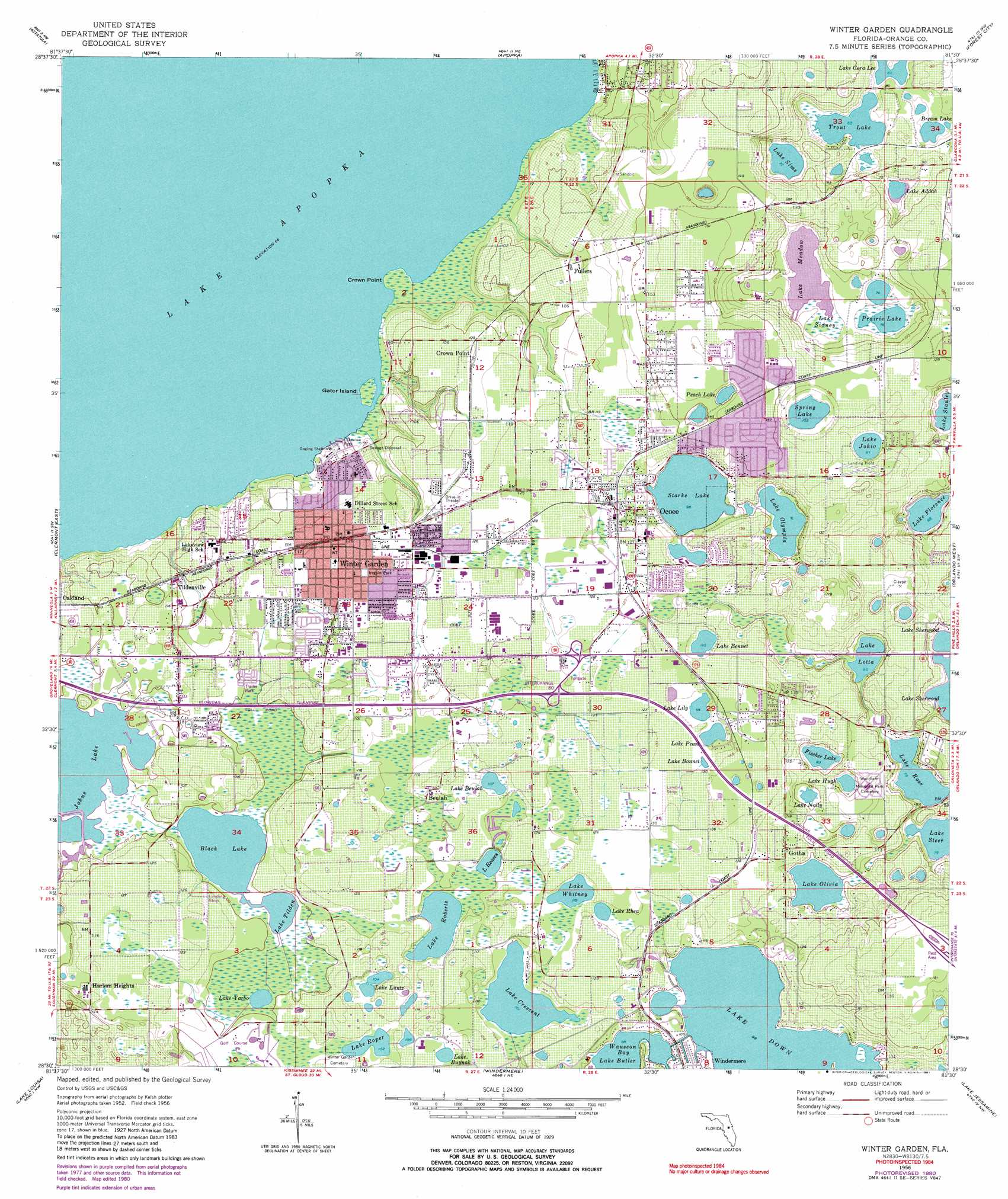
USGS Topo Quad 28081e5 - 1:24,000 scale
| Topo Map Name: | Winter Garden |
| USGS Topo Quad ID: | 28081e5 |
| Print Size: | ca. 21 1/4" wide x 27" high |
| Southeast Coordinates: | 28.5° N latitude / 81.5° W longitude |
| Map Center Coordinates: | 28.5625° N latitude / 81.5625° W longitude |
| U.S. State: | FL |
| Filename: | O28081E5.jpg |
| Download Map JPG Image: | Winter Garden topo map 1:24,000 scale |
| Map Type: | Topographic |
| Topo Series: | 7.5´ |
| Map Scale: | 1:24,000 |
| Source of Map Images: | United States Geological Survey (USGS) |
| Alternate Map Versions: |
Winter Garden FL 1956, updated 1957 Download PDF Buy paper map Winter Garden FL 1956, updated 1968 Download PDF Buy paper map Winter Garden FL 1956, updated 1972 Download PDF Buy paper map Winter Garden FL 1956, updated 1981 Download PDF Buy paper map Winter Garden FL 1956, updated 1981 Download PDF Buy paper map Winter Garden FL 2012 Download PDF Buy paper map Winter Garden FL 2015 Download PDF Buy paper map |
1:24,000 Topo Quads surrounding Winter Garden
Leesburg East |
Eustis |
Sorrento |
Sanford Sw |
Sanford |
Hewey In The Hills |
Astatula |
Apopka |
Forest City |
Casselberry |
Clermont West |
Clermont East |
Winter Garden |
Orlando West |
Orlando East |
Lake Nellie |
Lake Louisa |
Windermere |
Lake Jessamine |
Pine Castle |
Poyner |
Lake Louisa Sw |
Intercession City |
Kissimmee |
Saint Cloud North |
> Back to 28081e1 at 1:100,000 scale
> Back to 28080a1 at 1:250,000 scale
> Back to U.S. Topo Maps home
Winter Garden topo map: Gazetteer
Winter Garden: Airports
Carter Airport elevation 25m 82′Health Central Hospital Heliport elevation 40m 131′
Tilden Groves Airport elevation 36m 118′
Winter Garden: Bays
Wauseon Bay elevation 30m 98′Winter Garden: Capes
Crown Point elevation 20m 65′Winter Garden: Islands
Gator Island elevation 20m 65′Winter Garden: Lakes
Black Lake elevation 29m 95′Bream Lake elevation 24m 78′
Fischer Lake elevation 25m 82′
Lake Addah elevation 20m 65′
Lake Bennet elevation 33m 108′
Lake Beulah elevation 32m 104′
Lake Bonnet elevation 39m 127′
Lake Buynak elevation 34m 111′
Lake Cora Lee elevation 19m 62′
Lake Crescent elevation 31m 101′
Lake Down elevation 30m 98′
Lake Florence elevation 21m 68′
Lake Hugh elevation 25m 82′
Lake Johio elevation 34m 111′
Lake Lily elevation 34m 111′
Lake Lotta elevation 26m 85′
Lake Luntz elevation 31m 101′
Lake Meadow elevation 23m 75′
Lake Nally elevation 29m 95′
Lake Olivia elevation 29m 95′
Lake Olympia elevation 27m 88′
Lake Pearl elevation 35m 114′
Lake Reaves elevation 32m 104′
Lake Rhea elevation 33m 108′
Lake Roberts elevation 33m 108′
Lake Roper elevation 31m 101′
Lake Rose elevation 24m 78′
Lake Sims elevation 22m 72′
Lake Stanley elevation 22m 72′
Lake Steer elevation 25m 82′
Lake Tilden elevation 29m 95′
Lake Whitney elevation 33m 108′
Lake Yarbo elevation 29m 95′
Peach Lake elevation 45m 147′
Prairie Lake elevation 23m 75′
Spring Lake elevation 31m 101′
Starke Lake elevation 30m 98′
Trout Lake elevation 19m 62′
Winter Garden: Parks
Irrgain Park elevation 38m 124′Lakeview Park elevation 20m 65′
Winter Garden: Populated Places
Beulah elevation 37m 121′Crown Point elevation 33m 108′
Fullers elevation 34m 111′
Gotha elevation 37m 121′
Harlem Heights elevation 37m 121′
Hillcrest Heights Trailer Park elevation 46m 150′
Hyde Park Mobile Home Park elevation 34m 111′
Lake Apopka elevation 30m 98′
Lake Butter elevation 30m 98′
Lake Drive Mobile Home Park elevation 31m 101′
Minorville (historical) elevation 37m 121′
Ocoee elevation 37m 121′
Orange Tree Mobile Home Park elevation 38m 124′
Paradise Heights elevation 30m 98′
Tildenville elevation 31m 101′
Trailer City Mobile Home Park elevation 23m 75′
Westwood Village Mobile Home Park elevation 32m 104′
Winter Garden elevation 38m 124′
Winter Garden: Post Offices
Downtown Winter Garden Post Office elevation 36m 118′Ocoee Post Office elevation 36m 118′
Winter Garden Main Post Office elevation 37m 121′
Winter Garden Post Office elevation 33m 108′
Winter Garden: Swamps
Lake Sidney elevation 23m 75′Winter Garden digital topo map on disk
Buy this Winter Garden topo map showing relief, roads, GPS coordinates and other geographical features, as a high-resolution digital map file on DVD: