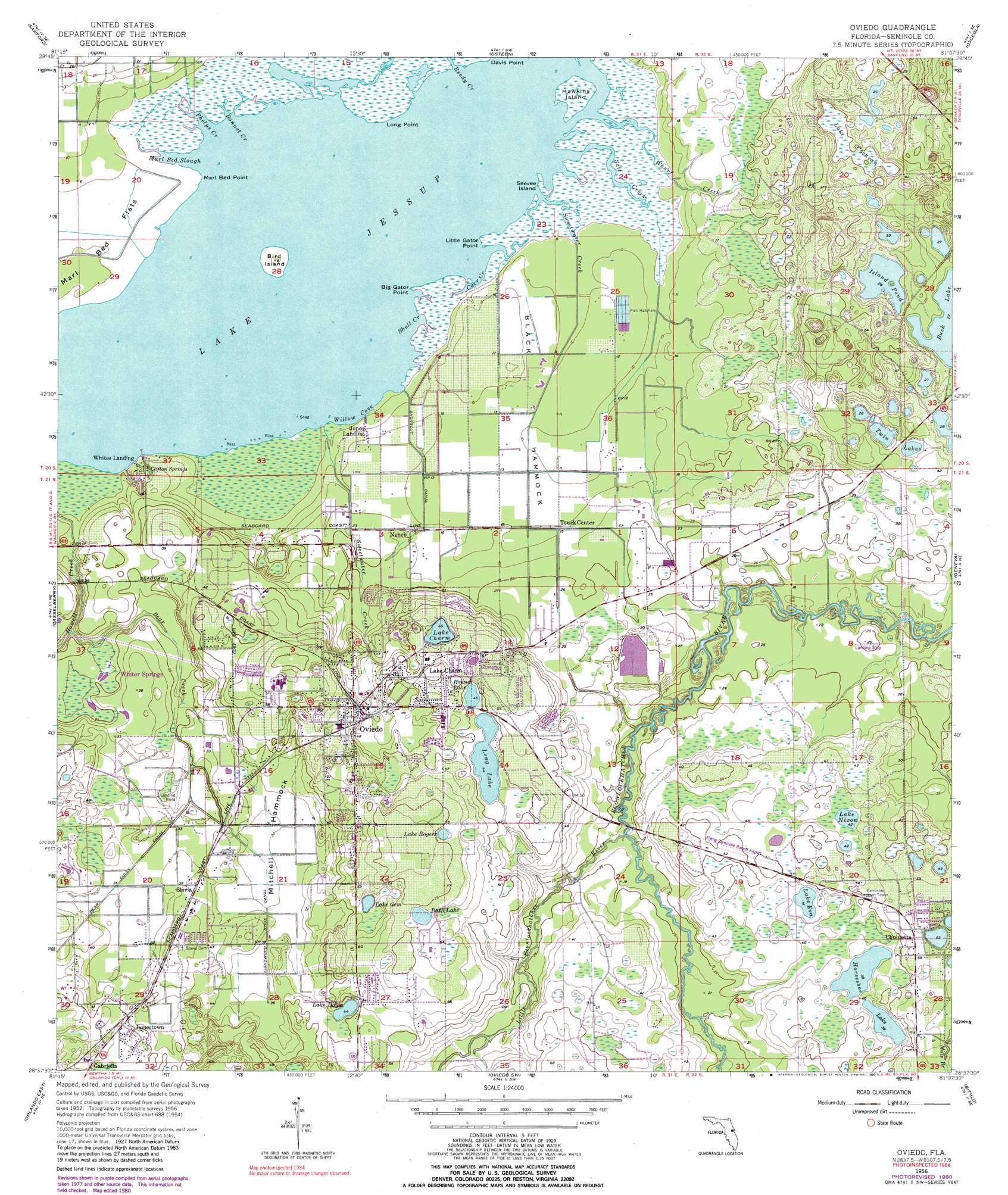
Oviedo Topo Map Florida
To zoom in, hover over the map of Oviedo
USGS Topo Quad 28081f2 - 1:24,000 scale
| Topo Map Name: | Oviedo |
| USGS Topo Quad ID: | 28081f2 |
| Print Size: | ca. 21 1/4" wide x 27" high |
| Southeast Coordinates: | 28.625° N latitude / 81.125° W longitude |
| Map Center Coordinates: | 28.6875° N latitude / 81.1875° W longitude |
| U.S. State: | FL |
| Filename: | O28081F2.jpg |
| Download Map JPG Image: | Oviedo topo map 1:24,000 scale |
| Map Type: | Topographic |
| Topo Series: | 7.5´ |
| Map Scale: | 1:24,000 |
| Source of Map Images: | United States Geological Survey (USGS) |
| Alternate Map Versions: |
Oviedo FL 1956, updated 1957 Download PDF Buy paper map Oviedo FL 1956, updated 1964 Download PDF Buy paper map Oviedo FL 1956, updated 1972 Download PDF Buy paper map Oviedo FL 1956, updated 1981 Download PDF Buy paper map Oviedo FL 1956, updated 1990 Download PDF Buy paper map Oviedo FL 2012 Download PDF Buy paper map Oviedo FL 2015 Download PDF Buy paper map |
1:24,000 Topo Quads surrounding Oviedo
Pine Lakes |
Orange City |
Lake Helen |
Lake Ashby |
Edgewater |
Sanford Sw |
Sanford |
Osteen |
Osceola |
Maytown |
Forest City |
Casselberry |
Oviedo |
Geneva |
Aurantia |
Orlando West |
Orlando East |
Oviedo Sw |
Bithlo |
Titusville Sw |
Lake Jessamine |
Pine Castle |
Narcoossee Nw |
Narcoossee Ne |
Lake Poinsett Nw |
> Back to 28081e1 at 1:100,000 scale
> Back to 28080a1 at 1:250,000 scale
> Back to U.S. Topo Maps home
Oviedo topo map: Gazetteer
Oviedo: Airports
Flying Seminole Ranch Airport elevation 15m 49′Lake Jessup Seaplane Base elevation 0m 0′
Oviedo: Bays
Carr Creek elevation 1m 3′Shell Creek elevation 0m 0′
Willow Cove elevation 0m 0′
Oviedo: Canals
Bear Gully Canal elevation 9m 29′Kansas Sweetwater Canal elevation 1m 3′
Lightwood Knox Canal elevation 9m 29′
Salt Creek Main Canal elevation 3m 9′
Oviedo: Capes
Big Gator Point elevation 0m 0′Davis Point elevation 0m 0′
Little Gator Point elevation 1m 3′
Long Point elevation 1m 3′
Marl Bed Point elevation 1m 3′
Oviedo: Flats
Marl Bed Flats elevation 1m 3′Oviedo: Guts
Bonnet Creek elevation 0m 0′Marl Bed Slough elevation 0m 0′
Phelps Creek elevation 0m 0′
Oviedo: Islands
Bird Island elevation 2m 6′Black Hammock elevation 2m 6′
Hawkins Island elevation 1m 3′
Mitchell Hammock elevation 9m 29′
Seevee Island elevation 1m 3′
Oviedo: Lakes
Bath Lake elevation 20m 65′Buck Lake elevation 8m 26′
Horseshoe Lake elevation 11m 36′
Island Pond elevation 8m 26′
Lake Catherine elevation 16m 52′
Lake Charm elevation 13m 42′
Lake Eva elevation 12m 39′
Lake Gem elevation 14m 45′
Lake Hayes elevation 13m 42′
Lake Jesup elevation 0m 0′
Lake Nixon elevation 12m 39′
Lake Rogers elevation 20m 65′
Long Lake elevation 13m 42′
Round Lake elevation 13m 42′
Twin Lakes elevation 9m 29′
Oviedo: Parks
Lake Jessup Conservation Area elevation 1m 3′Oviedo: Populated Places
Alafaya Woods elevation 23m 75′Gabriella elevation 17m 55′
Iowa City elevation 7m 22′
Jamestown elevation 16m 52′
Jones Landing elevation 3m 9′
Kolokee elevation 9m 29′
Lake Charm elevation 15m 49′
Neheb elevation 6m 19′
Oviedo elevation 15m 49′
Slavia elevation 12m 39′
Truck Corner elevation 4m 13′
Whites Landing elevation 1m 3′
Oviedo: Post Offices
Oviedo Post Office elevation 11m 36′Oviedo: Springs
Clifton Springs elevation 4m 13′Oviedo: Streams
Bear Creek elevation 2m 6′Bear Gully Creek elevation 7m 22′
Little Econlockhatchee River elevation 5m 16′
Reedy Creek elevation 0m 0′
Salt Creek elevation 0m 0′
Sweetwater Creek elevation 1m 3′
Wharf Creek elevation 0m 0′
Oviedo: Swamps
Lake Cockran elevation 7m 22′Oviedo digital topo map on disk
Buy this Oviedo topo map showing relief, roads, GPS coordinates and other geographical features, as a high-resolution digital map file on DVD: